Woods Hole Science Center

Sea-Floor Character and Sedimentary Processes in the Vicinity of Woods Hole, Massachusetts
![]() Title | Abstract | Introduction | Setting | Methods | Bathymetry and Backscatter | Seismic Profiles | Character and Processes | Data Catalog | Acknowledgments | References | Figures | Bottom Photography | Sediment Data | Contacts
Title | Abstract | Introduction | Setting | Methods | Bathymetry and Backscatter | Seismic Profiles | Character and Processes | Data Catalog | Acknowledgments | References | Figures | Bottom Photography | Sediment Data | Contacts
 |
||
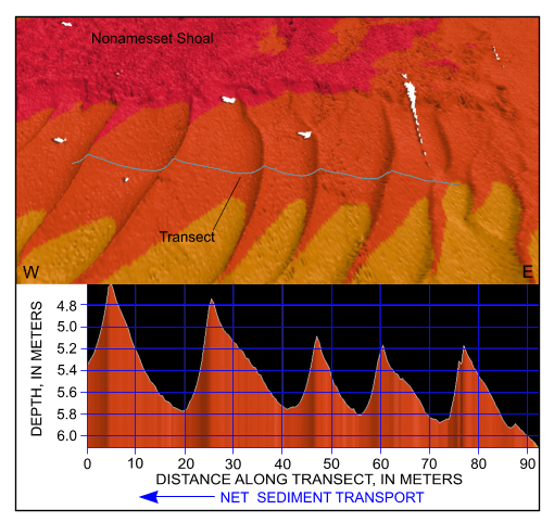
Figure 47. Detailed perspective view of the bathymetry looking north across the sand-wave field south of Nonamesset Shoal from the digital terrain model produced during National Oceanic and Atmospheric Administration survey H11077 of Woods Hole, Massachusetts. Line shows location of transect; cross section shows scaled bathymetry and that sand-wave asymmetry indicates net westward transport in this part of Vineyard Sound. Location of view is shown in figure 19. | ||