Woods Hole Science Center
Interpolation of Reconnaissance Multibeam and Single-Beam Bathymetry Offshore of Milford, Connecticut
|
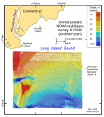
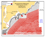
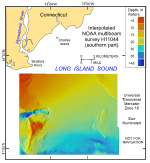
In the context of sea-floor mapping, the word “reconnaissance” typically refers to surveys with ship-track spacing too great to acquire 100-percent coverage of the sea floor at a specified resolution. This approach, which resulted in original bathymetric data sets that had areas of no data between the multibeam lines, was acceptable for nautical-charting purposes because 100-percent coverage was achieved with concurrently collected sidescan sonar (McMullen and others, 2005). The sidescan-sonar lines in this survey were spaced about 150 m apart, and the height of the towed sidescan fish above the sea floor was controlled by adjusting the cable length to allow data collection 100 m to each side. Because this resulted in a 50-m data overlap, the ship could maneuver around lobster pots and other obstructions and still efficiently survey 100 percent of the seabed. Conversely, the Reson multibeam system was hull mounted, and swath width, which varied with water depth but covered a strip averaging about 20 m wide, could not be increased without producing an unacceptably low data density. For purposes of comparison with the new interpolated data from the northern part of NOAA survey H11044, views of the original multibeam reconnaissance bathymetry are provided for southern (Poppe and others, 2006a) and northern parts of survey H11044 in figures 4 and 5, respectively, and of the interpolated bathymetry from the southern part in figure 6 (Poppe and others, 2006a). Areas of no data within the original survey are constituted approximately 10 percent of the southern part of H11044; however, largely due to the shallower water and use of a single-beam echosounder aboard the launch, areas of no data constituted approximately 61 percent of the 153-km² area within the northern part of survey H11044. |