
Woods Hole Science Center
![]() Title |
Introduction |
Geologic Setting |
Data Acquisition/Processing |
Bathymetry |
Seismic-Reflection Data |
Sidescan-Sonar Imagery |
Environments |
Sea-Floor Geology |
Summary |
GIS Data Catalog |
Acknowledgments |
References Cited |
Figures |
Contacts
Title |
Introduction |
Geologic Setting |
Data Acquisition/Processing |
Bathymetry |
Seismic-Reflection Data |
Sidescan-Sonar Imagery |
Environments |
Sea-Floor Geology |
Summary |
GIS Data Catalog |
Acknowledgments |
References Cited |
Figures |
Contacts
 |
||
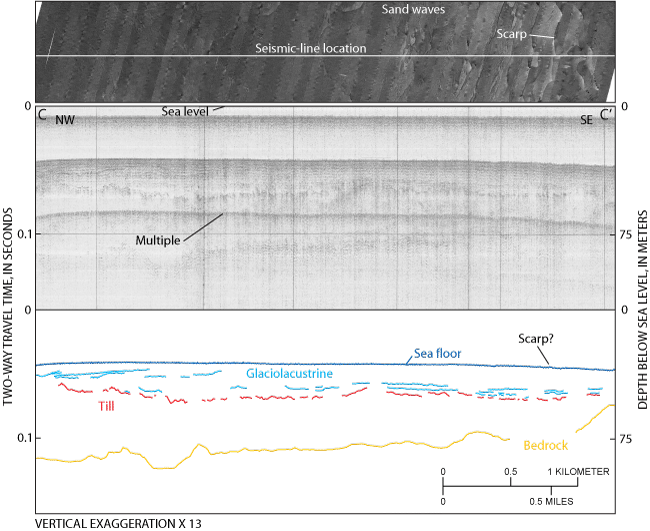
Figure 8. (Top) sidescan-sonar imagery associated with (middle) seismic-reflection profile C-C' (from Needell and other, 1983b) and (bottom) interpretation. The uppermost unit is composed of horizontal to gently dipping stratified sediments, interpreted to be glaciolacustrine deposits, which overlie till and bedrock. A small dip in the sea floor in the southern part of the profile occurs where small scarps cross the region. Sand waves are visible in the sidescan-sonar imagery northwest of the scarp. Location of seismic-reflection profile is shown in figure 6. | ||

