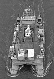
| Status | Inactive |
|---|---|
| Photo |  |
| Description | Length: 105 feet; Beam: 48 feet. |
| URL | https://www.dla.whoi.edu/ships/2d2aa4d8-c3db-4e24-b223-7346efb13d8a |
| Platform type | Vessel > Class 3 > Class 3 boats are longer than 40 feet. |
| USGS Center | USGS, Woods Hole Coastal and Marine Science Center (WHCMSC) |
| Owner |
Woods Hole Oceanographic Institution(WHOI)
Woods Hole, MA02543
|
| Field activity | Center | Survey location and description |
|---|---|---|
| 1970-002-FA | WHCMSC | Nantucket Sound, Vineyard Sound, Buzzards Bay, Cape Cod Bay, Massachusetts, United States, North America, North Atlantic; |
| 1977-043-FA | WHCMSC | Atlantis Canyon, United States, North America, North Atlantic; |
| 1978-030-FA | WHCMSC | Oceanographer Canyon, Georges Bank, United States, North America, North Atlantic; |
| 1980-023-FA | WHCMSC | Lydonia Canyon, Georges Bank, upper Continental Slope, United States, North America, North Atlantic; |
| 1980-028-FA | WHCMSC | Blake Escarpment, Florida, United States, North America, North Atlantic; |
| 1981-022-FA | WHCMSC | Lydonia Canyon, Georges Bank, United States, North America, North Atlantic; |
| 1981-024-FA | WHCMSC | Baltimore Canyon, Berkeley Canyon, Carteret Canyon, Hendrickson Canyon, U.S. Atlantic Continental Slope, United States, North America, North Atlantic; |
| 1982-030-FA | WHCMSC | Oceanographer Canyon, United States, North America, North Atlantic; |
| L179SC | PCMSC | Southern California Continental Margin |
| L279SC | PCMSC | Santa Barbara Channel |