Marine magnetic data collected offshore Oceanside, southern California during field activity 2017-686-FA from 2017-10-23 to 2017-10-31

Metadata also available as - [Outline] - [Parseable text] - [XML]

Frequently anticipated questions:


What does this data set describe?

Title:
Marine magnetic data collected offshore Oceanside, southern California during field activity 2017-686-FA from 2017-10-23 to 2017-10-31
Abstract:
This part of the data release contains marine magnetic data that were collected aboard the R/V Snavely in 2017 on U.S. Geological Survey cruise 2017-686-FA offshore Oceanside, southern California. The magnetic field data were collected to characterize the surface and subsurface properties of the study area, including unconsolidated sediment thickness and subsurface sediment horizons.
Supplemental_Information:
Additional information about the field activity from which these data were derived is available online at:
https://cmgds.marine.usgs.gov/fan_info.php?fan=2017-686-FA
Any use of trade, product, or firm names is for descriptive purposes only and does not imply endorsement by the U.S. Government.
  1. How might this data set be cited?
    Watt, Janet T., Sliter, Ray W., Conrad, James E., Lorenson, Thomas D., Papesh, Antoinette G., and Warrick, Jonathan A., 2021, Marine magnetic data collected offshore Oceanside, southern California during field activity 2017-686-FA from 2017-10-23 to 2017-10-31: data release DOI:10.5066/P9UELSBU, U.S. Geological Survey, Pacific Coastal and Marine Science Center, Santa Cruz, California.

    Online Links:

    This is part of the following larger work.

    Sliter, Ray W., Conrad, James E., Lorenson, Thomas D., Papesh, Antoinette G., Watt, Janet T., and Warrick, Jonathan A., 2021, Geophysical and sampling data collected offshore Oceanside, southern California during field activity 2017-686-FA from 2017-10-23 to 2017-10-31: data release DOI:10.5066/P9UELSBU, U.S. Geological Survey, Pacific Coastal and Marine Science Center, Santa Cruz, CA.

    Online Links:

  2. What geographic area does the data set cover?
    West_Bounding_Coordinate: -117.63597
    East_Bounding_Coordinate: -117.42379
    North_Bounding_Coordinate: 33.36704
    South_Bounding_Coordinate: 33.18941
  3. What does it look like?
    https://cmgds.marine.usgs.gov/data-releases/media/2020/10.5066-P9UELSBU/497e7ccd0d7549d4aaa5c2f7b021a3dc/2017-686-FA_mag_map.jpg (JPEG)
    Image map of magnetic anomalies overlaid on a greyscale shaded-relief bathymetry.
  4. Does the data set describe conditions during a particular time period?
    Beginning_Date: 17-Oct-2017
    Ending_Date: 31-Oct-2017
    Currentness_Reference:
    ground condition at time data were collected
  5. What is the general form of this data set?
    Geospatial_Data_Presentation_Form: comma-delimited text
  6. How does the data set represent geographic features?
    1. How are geographic features stored in the data set?
      This is a Point data set. It contains the following vector data types (SDTS terminology):
      • Point (163487)
    2. What coordinate system is used to represent geographic features?
      The map projection used is WGS 1984 UTM Zone 11N.
      Projection parameters:
      Scale_Factor_at_Central_Meridian: 0.9996
      Longitude_of_Central_Meridian: -117.0
      Latitude_of_Projection_Origin: 0.0
      False_Easting: 500000.0
      False_Northing: 0.0
      Planar coordinates are encoded using coordinate pair
      Abscissae (x-coordinates) are specified to the nearest 0.0001
      Ordinates (y-coordinates) are specified to the nearest 0.0001
      Planar coordinates are specified in Meter
      The horizontal datum used is D WGS 1984.
      The ellipsoid used is WGS 1984.
      The semi-major axis of the ellipsoid used is 6378137.0.
      The flattening of the ellipsoid used is 1/298.257223563.
      Vertical_Coordinate_System_Definition:
      Depth_System_Definition:
      Depth_Datum_Name: Local surface
      Depth_Resolution: 0.1
      Depth_Distance_Units: meters
      Depth_Encoding_Method: Attribute values
  7. How does the data set describe geographic features?
    2017-686-FA_magnetics
    Points representing magnetic field anomaly value in nanoteslas (nT) (Source: USGS)
    lat
    Latitude of data point in decimal degrees (Source: USGS)
    Range of values
    Minimum:33.1894121
    Maximum:33.3670425
    lon
    Longitude of data point in decimal degrees (Source: USGS)
    Range of values
    Minimum:-117.63597
    Maximum:-117.42379
    G882_raw
    Raw, unprocessed, total magnetic field value at G882 in nanoteslas (nT) (Source: USGS)
    Range of values
    Minimum:46390.75
    Maximum:46517.38
    DIURNAL
    Diurnal field correction at each G882 measurement in nanoteslas (nT) (Source: USGS)
    Range of values
    Minimum:-1732.35
    Maximum:-1609.68
    Line
    Survey line identifier (Source: USGS) Each line contained in the survey has a unique identifier
    Time
    Time of data point collection in HH:MM:SS format (Source: USGS)
    Range of values
    Minimum:00:00:00
    Maximum:24:00:00
    Date
    Date of data point collection in M/DD/YY format (Source: USGS)
    Range of values
    Minimum:10/25/17
    Maximum:10/30/17
    utm_x
    X coordinate of data point in meters (Source: USGS)
    Range of values
    Minimum:440789.7
    Maximum:460504.89
    utm_y
    Y coordinate of data point in meters (Source: USGS)
    Range of values
    Minimum:3672379.87
    Maximum:3692140.28
    DGRF_G882
    back-calculated total magnetic field value at base station in nanoteslas (nT) (Source: USGS)
    Range of values
    Minimum:46148.48
    Maximum:46227.65
    FRN_base
    back-calculated total magnetic field value at base station in nanoteslas (nT) (Source: USGS)
    Range of values
    Minimum:48116.1
    Maximum:48132.31
    IGRF_G882
    International Geomagnetic Reference Field (IGRF) valueat each G882 measurement in nanoteslas (nT) (Source: USGS)
    Range of values
    Minimum:48333.24
    Maximum:48333.24
    Resid_anom
    Calculated Total Field (Residual) Anomaly (see Process Step 6) in nanoteslas (nT) (Source: USGS)
    Range of values
    Minimum:432.63
    Maximum:559.23

Who produced the data set?

  1. Who are the originators of the data set? (may include formal authors, digital compilers, and editors)
    • Janet T. Watt
    • Ray W. Sliter
    • James E. Conrad
    • Thomas D. Lorenson
    • Antoinette G. Papesh
    • Jonathan A. Warrick
  2. Who also contributed to the data set?
  3. To whom should users address questions about the data?
    U.S. Geological Survey, Pacific Coastal and Marine Science Center
    Attn: PCMSC Science Data Coordinator
    2885 Mission Street
    Santa Cruz, CA

    831-460-4747 (voice)
    pcmsc_data@usgs.gov

Why was the data set created?

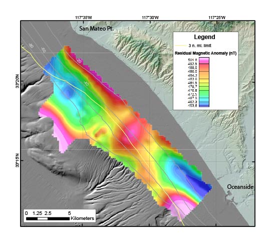
The U.S. Geological Survey (USGS) collected marine magnetic in 2017 offshore Oceanside, southern California. The goal of the magnetic survey was to provide magnetic field data to characterize the surface and subsurface properties of the study area, including unconsolidated sediment thickness and subsurface sediment horizons. This cruise was funded through partnerships with the Bureau of Ocean Energy Management (BOEM) and the State of California Ocean Protection Council (OPC).

How was the data set created?

  1. From what previous works were the data drawn?
  2. How were the data generated, processed, and modified?
    Date: 31-Oct-2017 (process 1 of 2)
    Magnetic field data were collected using a Geometrics G882 cesium-vapor marine magnetometer. Survey speeds were approximately 4.5 knots.
    Date: 18-Feb-2020 (process 2 of 2)
    Magnetic data were postprocessed following the methodology: 1)Initial Processing in MagMap2000 -Download base files from INTERMAGNET observatory (http://www.intermagnet.org/apps/dl_data_prel_e.php) -Despike base files and visually inspect for dropouts -Apply bias to DIURNAL (base) readings for GMT to local PDT + longitude diff. from base to survey = -7hrs + 0.15hrs =-24,660sec **NOTE: 0.0666667hr/deg longitude correction -Import .survey files, despike -Export files as Geosoft .xyz
    2)Import to Oasis
    3)Calculated IGRF for G882 data = IGRF_G882
    4)Back calculated Base Magnetometer measurements G882-DIURNAL_1 = FRN_base
    5)Calculated IGRF value at base station FRN = 42130.4nT
    6)Calculated Total Field (Residual) Anomaly (Resid_anom) using the following equation: A(x) = [F(x,t) - I(x)] - [FB(t) - IB]
    where: A(x)is total field anomaly at position x F(x,t) is the G882 reading at time t and position x I(x) is IGRF/DGRF at the G882 FB(t) is the base station reading at time t IB is the IGRF/DGRF at the base station
    To produce a georeferenced tiff file, data were gridded with ArcMap at 200m using minimum curvature. Colors are plotted using histogram equalize (not linear), to highlight subtle anomaly gradients. Projection is UTM z10N, wgs84.
  3. What similar or related data should the user be aware of?

How reliable are the data; what problems remain in the data set?

  1. How well have the observations been checked?
    Identified as best available version
  2. How accurate are the geographic locations?
    Position data were provided by a Hemisphere V100 Global Positioning System using L1, C/A code and carrier phase smoothing with a stated accuracy of 60 centimeters.
  3. How accurate are the heights or depths?
    not applicable for these data
  4. Where are the gaps in the data? What is missing?
    Dataset is considered complete for the information presented, as described in the abstract. Users are advised to read the rest of the metadata record carefully for additional details.
  5. How consistent are the relationships among the observations, including topology?
    No formal logical accuracy tests were conducted

How can someone get a copy of the data set?

Are there legal restrictions on access or use of the data?
Access_Constraints: None
Use_Constraints:
USGS-authored or produced data and information are in the public domain from the U.S. Government and are freely redistributable with proper metadata and source attribution. Please recognize and acknowledge the U.S. Geological Survey as the originator of the dataset and in products derived from these data. This information is not intended for navigation purposes.
  1. Who distributes the data set? (Distributor 1 of 1)
    U.S. Geological Survey, Pacific Coastal and Marine Science Center
    2885 Mission Street
    Santa Cruz, CA

    1-831-427-4747 (voice)
    pcmsc_data@usgs.gov
  2. What's the catalog number I need to order this data set? Downloadable magnetic field data. These data are available in comma separated format, shapefile format (2017-686-FA_magnetics.shp and associated files), and an interpolated georeferenced TIFF file, contained in a single zip file (2017-686-FA_magnetics.zip).
  3. What legal disclaimers am I supposed to read?
    Unless otherwise stated, all data, metadata and related materials are considered to satisfy the quality standards relative to the purpose for which the data were collected. Although these data and associated metadata have been reviewed for accuracy and completeness and approved for release by the U.S. Geological Survey (USGS), no warranty expressed or implied is made regarding the display or utility of the data on any other system or for general or scientific purposes, nor shall the act of distribution constitute any such warranty.
  4. How can I download or order the data?
  5. What hardware or software do I need in order to use the data set?
    The shapefile can be viewed with Esri or other GIS software. The CSV file can be viewed with any spreadsheet viewing software. The TIFF file is viewable with any graphics software.

Who wrote the metadata?

Dates:
Last modified: 17-Mar-2021
Metadata author:
U.S. Geological Survey, Pacific Coastal and Marine Science Center
Attn: PCMSC Science Data Coordinator
2885 Mission Street
Santa Cruz, CA

831-460-4747 (voice)
pcmsc_data@usgs.gov
Metadata standard:
Content Standard for Digital Geospatial Metadata (FGDC-STD-001-1998)

This page is <https://cmgds.marine.usgs.gov/catalog/pcmsc/DataReleases/CMGDS_DR_tool/DR_P9UELSBU/2017-686-FA_magnetics_metadata.faq.html>
Generated by mp version 2.9.50 on Tue Sep 21 18:17:09 2021