Marine magnetic data collected offshore Oceanside, southern California during field activity 2017-686-FA from 2017-10-23 to 2017-10-31

Metadata also available as - [Questions & Answers] - [Parseable text] - [XML]

Metadata:

Identification_Information:
Citation:
Citation_Information:
Originator: Janet T. Watt
Originator: Ray W. Sliter
Originator: James E. Conrad
Originator: Thomas D. Lorenson
Originator: Antoinette G. Papesh
Originator: Jonathan A. Warrick
Publication_Date: 2021
Title:
Marine magnetic data collected offshore Oceanside, southern California during field activity 2017-686-FA from 2017-10-23 to 2017-10-31
Geospatial_Data_Presentation_Form: comma-delimited text
Series_Information:
Series_Name: data release
Issue_Identification: DOI:10.5066/P9UELSBU
Publication_Information:
Publication_Place:
Pacific Coastal and Marine Science Center, Santa Cruz, California
Publisher: U.S. Geological Survey
Online_Linkage: https://doi.org/10.5066/P9UELSBU
Online_Linkage: Larger_Work_Citation:
Citation_Information:
Originator: Ray W. Sliter
Originator: James E. Conrad
Originator: Thomas D. Lorenson
Originator: Antoinette G. Papesh
Originator: Janet T. Watt
Originator: Jonathan A. Warrick
Publication_Date: 2021
Title:
Geophysical and sampling data collected offshore Oceanside, southern California during field activity 2017-686-FA from 2017-10-23 to 2017-10-31
Series_Information:
Series_Name: data release
Issue_Identification: DOI:10.5066/P9UELSBU
Publication_Information:
Publication_Place: Pacific Coastal and Marine Science Center, Santa Cruz, CA
Publisher: U.S. Geological Survey
Online_Linkage: https://doi.org/10.5066/P9UELSBU
Description:
Abstract:
This part of the data release contains marine magnetic data that were collected aboard the R/V Snavely in 2017 on U.S. Geological Survey cruise 2017-686-FA offshore Oceanside, southern California. The magnetic field data were collected to characterize the surface and subsurface properties of the study area, including unconsolidated sediment thickness and subsurface sediment horizons.
Purpose:
The U.S. Geological Survey (USGS) collected marine magnetic in 2017 offshore Oceanside, southern California. The goal of the magnetic survey was to provide magnetic field data to characterize the surface and subsurface properties of the study area, including unconsolidated sediment thickness and subsurface sediment horizons. This cruise was funded through partnerships with the Bureau of Ocean Energy Management (BOEM) and the State of California Ocean Protection Council (OPC).
Supplemental_Information:
Additional information about the field activity from which these data were derived is available online at:
https://cmgds.marine.usgs.gov/fan_info.php?fan=2017-686-FA
Any use of trade, product, or firm names is for descriptive purposes only and does not imply endorsement by the U.S. Government.
Time_Period_of_Content:
Time_Period_Information:
Range_of_Dates/Times:
Beginning_Date: 20171017
Ending_Date: 20171031
Currentness_Reference: ground condition at time data were collected
Status:
Progress: Planned
Maintenance_and_Update_Frequency: As needed
Spatial_Domain:
Bounding_Coordinates:
West_Bounding_Coordinate: -117.63597
East_Bounding_Coordinate: -117.42379
North_Bounding_Coordinate: 33.36704
South_Bounding_Coordinate: 33.18941
Keywords:
Theme:
Theme_Keyword_Thesaurus: USGS Metadata Identifier
Theme_Keyword: USGS:2b3aad9c-e1cd-4130-a841-4c2b8306f574
Theme:
Theme_Keyword_Thesaurus: ISO 19115 Topic Category
Theme_Keyword: oceans
Theme_Keyword: geoscientificInformation
Theme:
Theme_Keyword_Thesaurus: Data Categories for Marine Planning
Theme_Keyword: substrate
Theme:
Theme_Keyword_Thesaurus: USGS Thesaurus
Theme_Keyword: sea-floor characteristics
Theme_Keyword: magnetic field (earth)
Theme_Keyword: geophysics
Theme:
Theme_Keyword_Thesaurus: Marine Realms Information Bank (MRIB) keywords
Theme_Keyword: continental margin
Theme_Keyword: magnetic field observations
Theme:
Theme_Keyword_Thesaurus: None
Theme_Keyword: magnetic anomaly
Theme_Keyword: U.S. Geological Survey
Theme_Keyword: USGS
Theme_Keyword: Coastal and Marine Hazards and Resources Program
Theme_Keyword: CMHRP
Theme_Keyword: Pacific Coastal and Marine Science Center
Theme_Keyword: PCMSC
Place:
Place_Keyword_Thesaurus: Geographic Names Information System (GNIS)
Place_Keyword: Pacific Ocean
Place_Keyword: State of California
Place_Keyword: Oceanside
Place_Keyword: San Mateo Point
Place:
Place_Keyword_Thesaurus: NGA GEOnet Names Server (GNS)
Place_Keyword: North Pacific Ocean
Access_Constraints: None
Use_Constraints:
USGS-authored or produced data and information are in the public domain from the U.S. Government and are freely redistributable with proper metadata and source attribution. Please recognize and acknowledge the U.S. Geological Survey as the originator of the dataset and in products derived from these data. This information is not intended for navigation purposes.
Point_of_Contact:
Contact_Information:
Contact_Organization_Primary:
Contact_Organization:
U.S. Geological Survey, Pacific Coastal and Marine Science Center
Contact_Person: PCMSC Science Data Coordinator
Contact_Address:
Address_Type: mailing and physical
Address: 2885 Mission Street
City: Santa Cruz
State_or_Province: CA
Postal_Code: 95060
Contact_Voice_Telephone: 831-460-4747
Contact_Electronic_Mail_Address: pcmsc_data@usgs.gov
Browse_Graphic:
Browse_Graphic_File_Name: Browse_Graphic_File_Description:
Image map of magnetic anomalies overlaid on a greyscale shaded-relief bathymetry.
Browse_Graphic_File_Type: JPEG
Native_Data_Set_Environment: Digital, ASCII
Data_Quality_Information:
Attribute_Accuracy:
Attribute_Accuracy_Report: Identified as best available version
Logical_Consistency_Report: No formal logical accuracy tests were conducted
Completeness_Report:
Dataset is considered complete for the information presented, as described in the abstract. Users are advised to read the rest of the metadata record carefully for additional details.
Positional_Accuracy:
Horizontal_Positional_Accuracy:
Horizontal_Positional_Accuracy_Report:
Position data were provided by a Hemisphere V100 Global Positioning System using L1, C/A code and carrier phase smoothing with a stated accuracy of 60 centimeters.
Vertical_Positional_Accuracy:
Vertical_Positional_Accuracy_Report: not applicable for these data
Lineage:
Process_Step:
Process_Description:
Magnetic field data were collected using a Geometrics G882 cesium-vapor marine magnetometer. Survey speeds were approximately 4.5 knots.
Process_Date: 20171031
Process_Step:
Process_Description:
Magnetic data were postprocessed following the methodology: 1)Initial Processing in MagMap2000 -Download base files from INTERMAGNET observatory (http://www.intermagnet.org/apps/dl_data_prel_e.php) -Despike base files and visually inspect for dropouts -Apply bias to DIURNAL (base) readings for GMT to local PDT + longitude diff. from base to survey = -7hrs + 0.15hrs =-24,660sec **NOTE: 0.0666667hr/deg longitude correction -Import .survey files, despike -Export files as Geosoft .xyz
2)Import to Oasis
3)Calculated IGRF for G882 data = IGRF_G882
4)Back calculated Base Magnetometer measurements G882-DIURNAL_1 = FRN_base
5)Calculated IGRF value at base station FRN = 42130.4nT
6)Calculated Total Field (Residual) Anomaly (Resid_anom) using the following equation: A(x) = [F(x,t) - I(x)] - [FB(t) - IB]
where: A(x)is total field anomaly at position x F(x,t) is the G882 reading at time t and position x I(x) is IGRF/DGRF at the G882 FB(t) is the base station reading at time t IB is the IGRF/DGRF at the base station
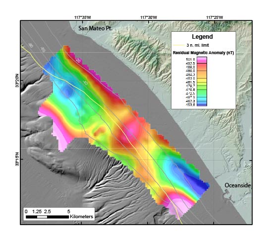
To produce a georeferenced tiff file, data were gridded with ArcMap at 200m using minimum curvature. Colors are plotted using histogram equalize (not linear), to highlight subtle anomaly gradients. Projection is UTM z10N, wgs84.
Process_Date: 20200218
Spatial_Data_Organization_Information:
Direct_Spatial_Reference_Method: Point
Point_and_Vector_Object_Information:
SDTS_Terms_Description:
SDTS_Point_and_Vector_Object_Type: Point
Point_and_Vector_Object_Count: 163487
Spatial_Reference_Information:
Horizontal_Coordinate_System_Definition:
Planar:
Map_Projection:
Map_Projection_Name: WGS 1984 UTM Zone 11N
Transverse_Mercator:
Scale_Factor_at_Central_Meridian: 0.9996
Longitude_of_Central_Meridian: -117.0
Latitude_of_Projection_Origin: 0.0
False_Easting: 500000.0
False_Northing: 0.0
Planar_Coordinate_Information:
Planar_Coordinate_Encoding_Method: coordinate pair
Coordinate_Representation:
Abscissa_Resolution: 0.0001
Ordinate_Resolution: 0.0001
Planar_Distance_Units: Meter
Geodetic_Model:
Horizontal_Datum_Name: D WGS 1984
Ellipsoid_Name: WGS 1984
Semi-major_Axis: 6378137.0
Denominator_of_Flattening_Ratio: 298.257223563
Vertical_Coordinate_System_Definition:
Depth_System_Definition:
Depth_Datum_Name: Local surface
Depth_Resolution: 0.1
Depth_Distance_Units: meters
Depth_Encoding_Method: Attribute values
Entity_and_Attribute_Information:
Detailed_Description:
Entity_Type:
Entity_Type_Label: 2017-686-FA_magnetics
Entity_Type_Definition:
Points representing magnetic field anomaly value in nanoteslas (nT)
Entity_Type_Definition_Source: USGS
Attribute:
Attribute_Label: lat
Attribute_Definition: Latitude of data point in decimal degrees
Attribute_Definition_Source: USGS
Attribute_Domain_Values:
Range_Domain:
Range_Domain_Minimum: 33.1894121
Range_Domain_Maximum: 33.3670425
Attribute:
Attribute_Label: lon
Attribute_Definition: Longitude of data point in decimal degrees
Attribute_Definition_Source: USGS
Attribute_Domain_Values:
Range_Domain:
Range_Domain_Minimum: -117.63597
Range_Domain_Maximum: -117.42379
Attribute:
Attribute_Label: G882_raw
Attribute_Definition:
Raw, unprocessed, total magnetic field value at G882 in nanoteslas (nT)
Attribute_Definition_Source: USGS
Attribute_Domain_Values:
Range_Domain:
Range_Domain_Minimum: 46390.75
Range_Domain_Maximum: 46517.38
Attribute:
Attribute_Label: DIURNAL
Attribute_Definition:
Diurnal field correction at each G882 measurement in nanoteslas (nT)
Attribute_Definition_Source: USGS
Attribute_Domain_Values:
Range_Domain:
Range_Domain_Minimum: -1732.35
Range_Domain_Maximum: -1609.68
Attribute:
Attribute_Label: Line
Attribute_Definition: Survey line identifier
Attribute_Definition_Source: USGS
Attribute_Domain_Values:
Unrepresentable_Domain: Each line contained in the survey has a unique identifier
Attribute:
Attribute_Label: Time
Attribute_Definition: Time of data point collection in HH:MM:SS format
Attribute_Definition_Source: USGS
Attribute_Domain_Values:
Range_Domain:
Range_Domain_Minimum: 00:00:00
Range_Domain_Maximum: 24:00:00
Attribute:
Attribute_Label: Date
Attribute_Definition: Date of data point collection in M/DD/YY format
Attribute_Definition_Source: USGS
Attribute_Domain_Values:
Range_Domain:
Range_Domain_Minimum: 10/25/17
Range_Domain_Maximum: 10/30/17
Attribute:
Attribute_Label: utm_x
Attribute_Definition: X coordinate of data point in meters
Attribute_Definition_Source: USGS
Attribute_Domain_Values:
Range_Domain:
Range_Domain_Minimum: 440789.7
Range_Domain_Maximum: 460504.89
Attribute:
Attribute_Label: utm_y
Attribute_Definition: Y coordinate of data point in meters
Attribute_Definition_Source: USGS
Attribute_Domain_Values:
Range_Domain:
Range_Domain_Minimum: 3672379.87
Range_Domain_Maximum: 3692140.28
Attribute:
Attribute_Label: DGRF_G882
Attribute_Definition:
back-calculated total magnetic field value at base station in nanoteslas (nT)
Attribute_Definition_Source: USGS
Attribute_Domain_Values:
Range_Domain:
Range_Domain_Minimum: 46148.48
Range_Domain_Maximum: 46227.65
Attribute:
Attribute_Label: FRN_base
Attribute_Definition:
back-calculated total magnetic field value at base station in nanoteslas (nT)
Attribute_Definition_Source: USGS
Attribute_Domain_Values:
Range_Domain:
Range_Domain_Minimum: 48116.1
Range_Domain_Maximum: 48132.31
Attribute:
Attribute_Label: IGRF_G882
Attribute_Definition:
International Geomagnetic Reference Field (IGRF) valueat each G882 measurement in nanoteslas (nT)
Attribute_Definition_Source: USGS
Attribute_Domain_Values:
Range_Domain:
Range_Domain_Minimum: 48333.24
Range_Domain_Maximum: 48333.24
Attribute:
Attribute_Label: Resid_anom
Attribute_Definition:
Calculated Total Field (Residual) Anomaly (see Process Step 6) in nanoteslas (nT)
Attribute_Definition_Source: USGS
Attribute_Domain_Values:
Range_Domain:
Range_Domain_Minimum: 432.63
Range_Domain_Maximum: 559.23
Distribution_Information:
Distributor:
Contact_Information:
Contact_Organization_Primary:
Contact_Organization:
U.S. Geological Survey, Pacific Coastal and Marine Science Center
Contact_Address:
Address_Type: mailing and physical
Address: 2885 Mission Street
City: Santa Cruz
State_or_Province: CA
Postal_Code: 95060
Contact_Voice_Telephone: 1-831-427-4747
Contact_Electronic_Mail_Address: pcmsc_data@usgs.gov
Resource_Description:
Downloadable magnetic field data. These data are available in comma separated format, shapefile format (2017-686-FA_magnetics.shp and associated files), and an interpolated georeferenced TIFF file, contained in a single zip file (2017-686-FA_magnetics.zip).
Distribution_Liability:
Unless otherwise stated, all data, metadata and related materials are considered to satisfy the quality standards relative to the purpose for which the data were collected. Although these data and associated metadata have been reviewed for accuracy and completeness and approved for release by the U.S. Geological Survey (USGS), no warranty expressed or implied is made regarding the display or utility of the data on any other system or for general or scientific purposes, nor shall the act of distribution constitute any such warranty.
Standard_Order_Process:
Digital_Form:
Digital_Transfer_Information:
Format_Name: shapefile, comma-delineated text, and TIFF
Format_Information_Content:
Downloadable magnetic field data. These data are available in comma separated format, shapefile format (2017-686-FA_magnetics.shp and associated files), and an interpolated georeferenced TIFF file, contained in a single zip file (2017-686-FA_magnetics.zip).
File_Decompression_Technique: zip
Transfer_Size: 13.1
Digital_Transfer_Option:
Online_Option:
Computer_Contact_Information: Access_Instructions:
Data can be downloaded using the Network_Resource_Name links. The first link is a direct link to download the zipped file of marine magnetic data. The second link points to a page with both the magnetic data and metadata. The third link points to a landing page for the entire data release, including other data types.
Fees: None.
Technical_Prerequisites:
The shapefile can be viewed with Esri or other GIS software. The CSV file can be viewed with any spreadsheet viewing software. The TIFF file is viewable with any graphics software.
Metadata_Reference_Information:
Metadata_Date: 20210317
Metadata_Contact:
Contact_Information:
Contact_Organization_Primary:
Contact_Organization:
U.S. Geological Survey, Pacific Coastal and Marine Science Center
Contact_Person: PCMSC Science Data Coordinator
Contact_Address:
Address_Type: mailing and physical
Address: 2885 Mission Street
City: Santa Cruz
State_or_Province: CA
Postal_Code: 95060
Contact_Voice_Telephone: 831-460-4747
Contact_Electronic_Mail_Address: pcmsc_data@usgs.gov
Metadata_Standard_Name: Content Standard for Digital Geospatial Metadata
Metadata_Standard_Version: FGDC-STD-001-1998

This page is <https://cmgds.marine.usgs.gov/catalog/pcmsc/DataReleases/CMGDS_DR_tool/DR_P9UELSBU/2017-686-FA_magnetics_metadata.html>
Generated by mp version 2.9.50 on Tue Sep 21 18:17:09 2021