Multichannel seismic-reflection data acquired off the coast of southern California - Part A 1997, 1998, 1999, and 2000

Metadata also available as - [Outline] - [Parseable text] - [XML]

Frequently anticipated questions:


What does this data set describe?

Title:
Multichannel seismic-reflection data acquired off the coast of southern California - Part A 1997, 1998, 1999, and 2000
Abstract:
Multichannel seismic-reflection (MCS) data were collected in the California Continental Borderland as part of southern California Earthquake Hazards Task. Five data acquisition cruises conducted over a six-year span collected MCS data from offshore Santa Barbara, California south to the Exclusive Economic Zone boundary with Mexico. The primary mission was to map late Quaternary deformation as well as identify and characterize fault zones that have potential to impact high population areas of southern California. To meet its objectives, the project work focused on the distribution, character, and relative intensity of active (i.e., Holocene) deformation along the continental shelf and basins adjacent to the most highly populated areas. In addition, the project examined the Pliocene-Pleistocene record of how deformation shifted in space and time to help identify actively deforming structures that may constitute current significant seismic hazards.
The MCS data accessible through this report cover the first four years of survey activity and include data from offshore Malibu coastal area west of Santa Monica, California to the southern survey limit offshore San Diego. The MCS data, which were collected with a 250-m-long, 24-channel streamer used a small gas-injector airgun source. This system provided optimum resolution of the upper 1 to 2 km of sediment for mapping active fault systems. The report includes trackline maps showing the location of the data, as well as both digital data files (SEG-Y) and images of all of the profiles.
These data are also available via GeoMapApp (http://www.geomapapp.org/) and Virtual Ocean ( http://www.virtualocean.org/) earth science exploration and visualization applications.
Supplemental_Information:
Additional information about the field activities from which these data were derived is available online at:
https://cmgds.marine.usgs.gov/fan_info.php?fan=S197SC https://cmgds.marine.usgs.gov/fan_info.php?fan=A198SC https://cmgds.marine.usgs.gov/fan_info.php?fan=O199SC https://cmgds.marine.usgs.gov/fan_info.php?fan=A100SC
Any use of trade, product, or firm names is for descriptive purposes only and does not imply endorsement by the U.S. Government.
  1. How might this data set be cited?
    Sliter, Ray W., Normark, William R., and Gutmacher, Christina E., 2005, Multichannel seismic-reflection data acquired off the coast of southern California - Part A 1997, 1998, 1999, and 2000: U.S. Geological Survey Open-File Report USGS OFR 2005-1084, United States Geological Survey, Menlo Park, California.

    Online Links:

  2. What geographic area does the data set cover?
    West_Bounding_Coordinate: -119.00000
    East_Bounding_Coordinate: -117.00000
    North_Bounding_Coordinate: +34.16667
    South_Bounding_Coordinate: +32.50000
  3. What does it look like?
    https://pubs.usgs.gov/of/2005/1084/images/ge-overview.png (PNG)
    Index map of area covered in this report.
    https://pubs.usgs.gov/of/2005/1084/maps/o199/lines/221.html (JPEG)
    Example of Multichannel seismic data accessible via this report.
  4. Does the data set describe conditions during a particular time period?
    Beginning_Date: 01-Aug-1997
    Ending_Date: 01-Oct-2000
    Currentness_Reference:
    Time span of data collection and initial archiving.
  5. What is the general form of this data set?
    Geospatial_Data_Presentation_Form:
    Text report containing graphical map images and geophysical data images (no spatial referencing).
  6. How does the data set represent geographic features?
    1. How are geographic features stored in the data set?
    2. What coordinate system is used to represent geographic features?
      Grid_Coordinate_System_Name: Universal Transverse Mercator
      Universal_Transverse_Mercator:
      UTM_Zone_Number: 11
      Transverse_Mercator:
      Scale_Factor_at_Central_Meridian: 0.9996
      Longitude_of_Central_Meridian: -117.0
      Latitude_of_Projection_Origin: 0.0
      False_Easting: 500000
      False_Northing: 0
      Planar coordinates are encoded using coordinate pair
      Abscissae (x-coordinates) are specified to the nearest 25
      Ordinates (y-coordinates) are specified to the nearest 25
      Planar coordinates are specified in Meters
      The horizontal datum used is North American Datum of 1983.
      The ellipsoid used is GRS1980.
      The semi-major axis of the ellipsoid used is 6378206.4.
      The flattening of the ellipsoid used is 1/294.98.
  7. How does the data set describe geographic features?
    Entity_and_Attribute_Overview:
    Locations of data profiles are shown as color-coded map images at an unspecified projection and scale. These HTML image maps allow mouse over trackline details and links to profile displays. The images of the reflection profiles are rendered in TIFF and JPEG image formats. Links are provided to the SEG-Y digital data for each line.
    Entity_and_Attribute_Detail_Citation: none

Who produced the data set?

  1. Who are the originators of the data set? (may include formal authors, digital compilers, and editors)
    • Ray W. Sliter
    • William R. Normark
    • Christina E. Gutmacher
  2. Who also contributed to the data set?
    Peter Triezenberg produced the interactive web pages for this report.
  3. To whom should users address questions about the data?
    U.S. Geological Survey, Pacific Coastal and Marine Science Center
    Attn: PCMSC Science Data Coordinator
    2885 Mission Street
    Santa Cruz, CA

    831-427-4747 (voice)
    pcmsc_data@usgs.gov

Why was the data set created?

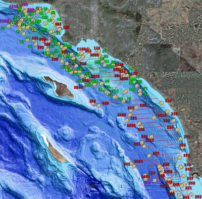
These MCS data were collected as part of a project to identify the active fault systems in the southern California coastal zone, including the continental shelf and adjacent deep basins, that pose the greatest potential seismic hazards for the most populated urban corridor along the U.S. Pacific margin. See http://walrus.wr.usgs.gov/cabrillo/tierra/index.html for more information. This report is prepared to make these data available to science researchers, students, and other interested parties.

How was the data set created?

  1. From what previous works were the data drawn?
  2. How were the data generated, processed, and modified?
    Date: 2003 (process 1 of 7)
    Refer to report sections "Cruise history", "Data acquisition methods", and "Data processing" for details of geophysical data acquisition and processing sequence used for MCS data in this report. Ray W. Sliter
    Date: 2004 (process 2 of 7)
    Plotted shot point map of cruises using GMT <http://gmt.soest.hawaii.edu/> to create sub-maps. Broke area into four sections for better viewing. Converted plots to TIFF and JPEG files for zooming in on sections. Ray W. Sliter
    Date: 2004 (process 3 of 7)
    Used GEODAS (GEOphysical DAta System) to create a custom bathymetric and topographic grid for the southern California region covered by the cruise index map. The website is: <http://www.ngdc.noaa.gov/mgg/geodas/geodas.html>. The parameters used are as follows: Grid database: US Coastal Relief Model Grids Lat/Lon Area Bounds: 34.16667 N to 32.50 N, 119.0 W to 117.0 W Grid Cell Size: 3 seconds Grid Cell Value Parameters: 4-byte integers, 10ths of meters Grid Format: xyz (lon, lat, depth) format, no header, space-delimited, exclude empty cells. Peter Triezenberg
    Date: 2005 (process 4 of 7)
    Plotted tracklines of seismic reflection profiles using GMT <http://gmt.soest.hawaii.edu/> to create maps. Created HTML image maps to allow mouse-over of trackline details and links to profile displays. Peter Triezenberg
    Date: 24-Jan-2017 (process 5 of 7)
    Keywords section of metadata optimized for discovery in USGS Coastal and Marine Geology Data Catalog. Person who carried out this activity:
    U.S. Geological Survey
    Attn: Alan O. Allwardt
    Contractor -- Information Specialist
    2885 Mission Street
    Santa Cruz, CA

    831-460-7551 (voice)
    831-427-4748 (FAX)
    aallwardt@usgs.gov
    Date: 04-Aug-2020 (process 6 of 7)
    Edits were made to bring the metadata up to current PCMSC standards including standardizing authors' names, adding a doi# link, correcting typos, refining keywords, and using current access and distribution liability statements. Point of Contact and Metadata Contact information sections were changed to static PCMSC contact information. No data were changed. Users are advised to compare the metadata date of this file to any similar file to ensure they are using the most recent version. Person who carried out this activity:
    Susan A Cochran
    U.S. Geological Survey, Pacific Coastal and Marine Science Center
    2885 Mission St.
    Santa Cruz, CA
    United States

    831-460-7545 (voice)
    scochran@usgs.gov
    Date: 19-Oct-2020 (process 7 of 7)
    Edited metadata to add keywords section with USGS persistent identifier as theme keyword. No data were changed. Person who carried out this activity:
    U.S. Geological Survey
    Attn: VeeAnn A. Cross
    Marine Geologist
    384 Woods Hole Road
    Woods Hole, MA

    508-548-8700 x2251 (voice)
    508-457-2310 (FAX)
    vatnipp@usgs.gov
  3. What similar or related data should the user be aware of?

How reliable are the data; what problems remain in the data set?

  1. How well have the observations been checked?
    Data have not been independently verified.
  2. How accurate are the geographic locations?
    Tracklines shown are for the GPS antenna on the ships collecting the multichannel seismic data. Shot point numbers in the data files correspond to those in the navigation files. The horizontal positional accuracy of the seismic data thus linked to ship's position is estimated to be within 40 meters.
  3. How accurate are the heights or depths?
    Depths shown in the seismic data files are in milliseconds (round trip travel time) and are referenced to sea level.
  4. Where are the gaps in the data? What is missing?
    Reference the full report for a description of data coverage. All MCS data collected on the referenced cruises have been included in this report, with the exception of those collected in Los Angeles Harbor and shelf, for an aquifer study, on A-1-00-SC. Some seismic profiles have gaps in them due to system crashes or intentional shutdowns as required, under terms of our operating permit, to protect marine mammals.
  5. How consistent are the relationships among the observations, including topology?
    Undetermined.

How can someone get a copy of the data set?

Are there legal restrictions on access or use of the data?
Access_Constraints: None
Use_Constraints:
USGS-authored or produced data and information are in the public domain from the U.S. Government and are freely redistributable with proper metadata and source attribution. Please recognize and acknowledge the U.S. Geological Survey as the originator(s) of the dataset and in products derived from these data. This information is not intended for navigation purposes.
  1. Who distributes the data set? (Distributor 1 of 1)
    U.S. Geological Survey, Pacific Coastal and Marine Science Center
    Attn: PCMSC Science Data Coordinator
    2885 Mission Street
    Santa Cruz, CA
    US

    831-427-4747 (voice)
    pcmsc_data@usgs.gov
  2. What's the catalog number I need to order this data set? United States Geological Survey Open-File Report 2005-1084 This report is distributed on-line only. Access it at https://pubs.usgs.gov/of/2005/1084/.
  3. What legal disclaimers am I supposed to read?
    Unless otherwise stated, all data, metadata and related materials are considered to satisfy the quality standards relative to the purpose for which the data were collected. Although these data and associated metadata have been reviewed for accuracy and completeness and approved for release by the U.S. Geological Survey (USGS), no warranty expressed or implied is made regarding the display or utility of the data on any other system or for general or scientific purposes, nor shall the act of distribution constitute any such warranty.
  4. How can I download or order the data?

Who wrote the metadata?

Dates:
Last modified: 19-Oct-2020
Metadata author:
U.S. Geological Survey, Pacific Coastal and Marine Science Center
Attn: PCMSC Science Data Coordinator
2885 Mission Street
Santa Cruz, CA
US

831-427-4747 (voice)
pcmsc_data@usgs.gov
Metadata standard:
Content Standard for Digital Geospatial Metadata (FGDC-STD-001-1998)

This page is <https://cmgds.marine.usgs.gov/catalog/pcmsc/SeriesReports/OFR/OFR_2005-1084/MSC_SoCal_PartA.faq.html>
Generated by mp version 2.9.50 on Fri Oct 8 17:49:27 2021