Sound velocity profile data from an AML Oceanographic MVP30 and Minos X collected in Cape Cod Bay, Massachusetts during USGS Field Activity 2019-002-FA (PNG images, SVP text, and point shapefile, GCS WGS 84)

Metadata also available as - [Questions & Answers] - [Parseable text] - [XML]

Metadata:

Identification_Information:
Citation:
Citation_Information:
Originator: Seth D. Ackerman
Publication_Date: 20220718
Title:
Sound velocity profile data from an AML Oceanographic MVP30 and Minos X collected in Cape Cod Bay, Massachusetts during USGS Field Activity 2019-002-FA (PNG images, SVP text, and point shapefile, GCS WGS 84)
Edition: 1.0
Geospatial_Data_Presentation_Form: PNG images, ASCII text, and Shapefile
Series_Information:
Series_Name: data release
Issue_Identification: DOI:10.5066/P99DR4PN
Publication_Information:
Publication_Place:
Woods Hole Coastal and Marine Science Center, Woods Hole, Massachusetts
Publisher:
U.S. Geological Survey, Coastal and Marine Hazards and Resources Program
Online_Linkage: https://doi.org/10.5066/P99DR4PN
Online_Linkage: Larger_Work_Citation:
Citation_Information:
Originator: Seth D. Ackerman
Originator: David S. Foster
Originator: Brian D. Andrews
Originator: William W. Danforth
Originator: Wayne E. Baldwin
Originator: Emily C. Huntley
Originator: Charles R. Worley
Originator: Laura L. Brothers
Publication_Date: 2022
Title:
High-resolution geophysical and geological data collected in Cape Cod Bay, Massachusetts during USGS Field Activities 2019-002-FA and 2019-034-FA
Edition: 1.0
Series_Information:
Series_Name: data release
Issue_Identification: DOI:10.5066/P99DR4PN
Publication_Information:
Publication_Place: Reston, VA
Publisher: U.S. Geological Survey
Other_Citation_Details:
Suggested citation: Ackerman, S.D., Foster, D.S., Andrews, B.D., Danforth, W.W., Baldwin, W.E., Huntley, E.C., Worley, C.R., and Brothers, L.L., 2022, High-resolution geophysical and geological data collected in Cape Cod Bay, Massachusetts during USGS Field Activities 2019-002-FA and 2019-034-FA: U.S. Geological Survey data release, https://doi.org/10.5066/P99DR4PN.
Online_Linkage: https://doi.org/10.5066/P99DR4PN
Online_Linkage:
Description:
Abstract:
Accurate data and maps of sea floor geology are important first steps toward protecting fish habitat, delineating marine resources, and assessing environmental changes due to natural or human impacts. To address these concerns the U.S. Geological Survey, in cooperation with the Massachusetts Office of Coastal Zone Management (CZM), comprehensively mapped the Cape Cod Bay sea floor to characterize the surface and shallow subsurface geologic framework. Geophysical data collected include swath bathymetry, backscatter, and seismic reflection profile data. Ground-truth data, including sediment samples, underwater video, and bottom photographs were also collected. This effort is part of a long-term collaboration between the USGS and the Commonwealth of Massachusetts to map the State’s waters, support research on the Quaternary evolution of coastal Massachusetts, the influence of sea-level change and sediment supply on coastal evolution, and efforts to understand the type, distribution, and quality of subtidal marine habitats. This collaboration produces high-resolution geologic maps and Geographic Information System (GIS) data that serve the needs of research, management and the public. Data collected as part of this mapping cooperative continue to be released in a series of USGS Open-File Reports and Data Releases (https://www.usgs.gov/centers/whcmsc/science/geologic-mapping-massachusetts-seafloor). This data release provides the geophysical and geologic sampling data collected in Cape Cod Bay during USGS Field Activities 2019-002-FA and 2019-034-FA in 2019.
Purpose:
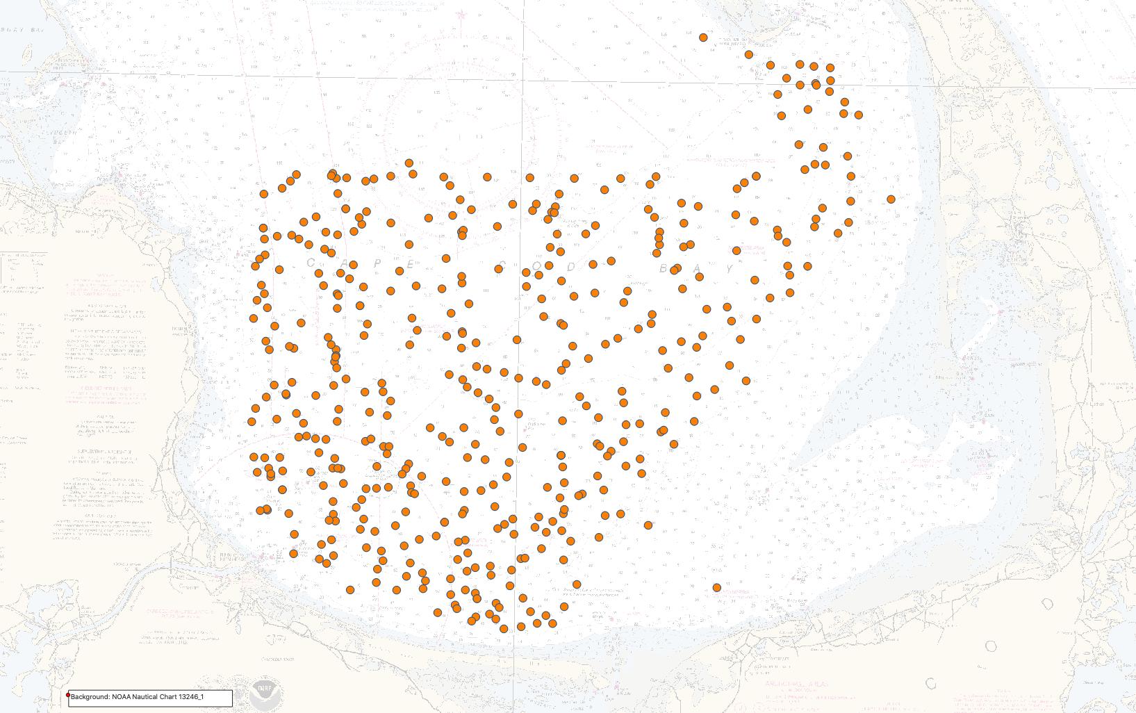
This dataset is used to display the locations of sound velocity profiles collected with an AML MVP30 (moving vessel profiler) and an AML Minos X SVP (sound velocity profiler) during survey 2019-002-FA in Cape Cod Bay, Massachusetts. The information contained within the sound velocity profiles is needed to account for refraction artifacts that may be present within raw swath bathymetric data. This dataset contains graphs of the sound velocity profile at each station location, as well as location in Geographic Coordinate System (GCS) WGS 84 latitude and longitude, time of day and date of collection.
Supplemental_Information:
Support for 2019-002-FA was provided to the USGS from the Massachusetts Office of Coastal Zone Management. Additional information on the field activities associated with this project are available at https://cmgds.marine.usgs.gov/fan_info.php?fan=2019-002-FA and https://cmgds.marine.usgs.gov/fan_info.php?fan=2019-034-FA.
Time_Period_of_Content:
Time_Period_Information:
Range_of_Dates/Times:
Beginning_Date: 20190801
Ending_Date: 20190829
Currentness_Reference:
ground condition during field activity 2019-002-FA: 20190801-20190829
Status:
Progress: Complete
Maintenance_and_Update_Frequency: None planned.
Spatial_Domain:
Bounding_Coordinates:
West_Bounding_Coordinate: -70.49556
East_Bounding_Coordinate: -70.10639
North_Bounding_Coordinate: 42.02083
South_Bounding_Coordinate: 41.74917
Keywords:
Theme:
Theme_Keyword_Thesaurus: USGS Metadata Identifier
Theme_Keyword: USGS:82bcd007-884a-4fbc-b74c-fbfba07010e8
Theme:
Theme_Keyword_Thesaurus: None
Theme_Keyword: U.S. Geological Survey
Theme_Keyword: USGS
Theme_Keyword: Woods Hole Coastal and Marine Science Center
Theme_Keyword: WHCMSC
Theme_Keyword: Coastal and Marine Hazards and Resources Program
Theme_Keyword: CMHRP
Theme_Keyword: Department of the Interior
Theme_Keyword: DOI
Theme_Keyword: Massachusetts Office of Coastal Zone Management
Theme_Keyword: CZM
Theme_Keyword: MassCZM
Theme_Keyword: field activity number 2019-002-FA
Theme_Keyword: field activity number 2019-034-FA
Theme_Keyword: moving vessel profiler
Theme_Keyword: shapefile
Theme_Keyword: sound velocity profile
Theme_Keyword: AML Oceanographic Moving Vessel Profiler
Theme_Keyword: AML Oceanographic MVP30
Theme_Keyword: AML Minos X
Theme_Keyword: Esri shapefile
Theme_Keyword: M/V Warren Jr
Theme_Keyword: MVP
Theme_Keyword: SVP
Theme_Keyword: SSP
Theme_Keyword: sound speed profile
Theme_Keyword: Marine Geology
Theme:
Theme_Keyword_Thesaurus: ISO 19115 Topic Category
Theme_Keyword: oceans
Theme_Keyword: geoscientificInformation
Theme_Keyword: location
Theme:
Theme_Keyword_Thesaurus: USGS Thesaurus
Theme_Keyword: sound velocity
Theme_Keyword: profiles
Theme_Keyword: ocean sciences
Theme_Keyword: navigational data
Place:
Place_Keyword_Thesaurus: None
Place_Keyword: United States of America
Place_Keyword: Atlantic Ocean
Place_Keyword: Atlantic Margin
Place_Keyword: Cape Cod Bay
Place_Keyword: Cape Cod
Place_Keyword: Massachusetts
Place_Keyword: Gulf of Maine
Temporal:
Temporal_Keyword_Thesaurus: none
Temporal_Keyword: 2019
Access_Constraints: none
Use_Constraints:
Public domain data from the U.S. Government are freely redistributable with proper metadata and source attribution. Please recognize the U.S. Geological Survey as the originator of the dataset.
Point_of_Contact:
Contact_Information:
Contact_Person_Primary:
Contact_Person: Seth Ackerman
Contact_Organization: U.S. Geological Survey
Contact_Position: Geologist
Contact_Address:
Address_Type: mailing and physical address
Address: 384 Woods Hole Rd.
City: Woods Hole
State_or_Province: MA
Postal_Code: 02543-1598
Country: USA
Contact_Voice_Telephone: 508-548-8700 x2315
Contact_Facsimile_Telephone: 508-457-2310
Contact_Electronic_Mail_Address: sackerman@usgs.gov
Browse_Graphic:
Browse_Graphic_File_Name: Browse_Graphic_File_Description:
Thumbnail image of sound speed profile locations collected in Cape Cod Bay, Massachusetts.
Browse_Graphic_File_Type: JPEG
Data_Set_Credit:
The authors acknowledge our fellow participants of the Cape Cod Bay field activities 2019-002-FA (Walter Barnhardt, Luke Bennett, Eric Moore, Alex Nichols, Jake Fredericks, and Dan Kennedy) and 2019-034-FA (Dann Blackwood, Eric Moore, and Alex Nichols); the crew of the M/V Warren Jr and the R/V Tioga; and our sea floor mapping group onshore support team during these surveys (Jane Denny, PJ Bernard, Barry Irwin, and Emile Bergeron).
Cross_Reference:
Citation_Information:
Originator: Fofonoff, N.
Originator: Millard, R.
Publication_Date: 1983
Title:
Algorithms for Computation of Fundamental Properties of Seawater
Series_Information:
Series_Name: UNESCO Tech. Pap. Mar. Sci.
Issue_Identification: 44
Online_Linkage:
Cross_Reference:
Citation_Information:
Originator: Pendleton, E.A.
Originator: Baldwin, W.E.
Originator: Barnhardt., W.A.
Originator: Ackerman, S.D.
Originator: Foster, D.S.
Originator: Andrews, B.D.
Originator: Schwab, W.C.
Publication_Date: 2013
Title:
Shallow Geology, Sea-floor Texture, and Physiographic Zones of the Inner Continental Shelf from Nahant to Northern Cape Cod Bay, Massachusetts
Series_Information:
Series_Name: Open-File Report
Issue_Identification: 2012-1157
Publication_Information:
Publication_Place: Woods Hole Coastal and Marine Science Center, Woods Hole, MA
Publisher: U.S. Geological Survey, Coastal and Marine Geology Program
Online_Linkage: https://doi.org/10.3133/ofr20121157
Cross_Reference:
Citation_Information:
Originator: Andrews, B.D.
Originator: Ackerman, S.D.
Originator: Baldwin, W.E.
Originator: Barnhardt, W.A.
Publication_Date: 2010
Title:
Geophysical and Sampling Data from the Inner Continental Shelf: Northern Cape Cod Bay, Massachusetts
Edition: 1.0
Geospatial_Data_Presentation_Form: raster digital data
Series_Information:
Series_Name: Open-File Report
Issue_Identification: 2010-1006
Publication_Information:
Publication_Place: Woods Hole Coastal and Marine Science Center, Woods Hole, MA
Publisher: U.S. Geological Survey, Coastal and Marine Geology Program
Online_Linkage: https://doi.org/10.3133/ofr20101006
Cross_Reference:
Citation_Information:
Originator: Seth D. Ackerman
Originator: David S. Foster
Originator: William W. Danforth
Originator: Emily C. Huntley
Publication_Date: 2019
Title:
High-resolution geophysical and sampling data collected off Town Neck Beach in Sandwich, Massachusetts, 2016
Edition: 1.0
Series_Information:
Series_Name: data release
Issue_Identification: DOI:10.5066/P9HZHXXV
Publication_Information:
Publication_Place: Reston, VA
Publisher: U.S. Geological Survey
Other_Citation_Details:
Suggested citation: Ackerman S.D., Foster D.S., Danforth W.W., and Huntley, E.C., 2019, High-resolution geophysical and sampling data collected off Town Neck Beach in Sandwich, Massachusetts, 2016: U.S. Geological Survey data release, https://doi.org/10.5066/P9HZHXXV.
Online_Linkage: https://doi.org/10.5066/P9HZHXXV
Online_Linkage:
Data_Quality_Information:
Logical_Consistency_Report:
Sound velocity profiles were acquired with an AML Oceanographic MVP30 Moving Vessel Profiler (MVP) or an AML Minos X Sound Velocity Profiler (SVP).
Completeness_Report:
A total of 439 sound velocity profiles were collected during cruise 2019-002-FA and are included in this dataset. Profiles were renamed as a result of the extra processing done after sound velocity profile edits were done in CARIS HIPS (see process steps). The new file naming convention is based on the day and time the data were collected (see Entity and Attribute Information). Data were collected on the following dates: 20190801-20190829 (Julian day 213-241).
Positional_Accuracy:
Horizontal_Positional_Accuracy:
Horizontal_Positional_Accuracy_Report:
Navigation data were acquired using the WGS 84 coordinate system with an Applanix POS MV Wavemaster (model 220, V5), which blends Global Navigation Satellite Systems (GNSS) with acceleration data from a Motion Reference Unit (MRU) and GPS azimuthal heading. The POS MV was configured with two AeroAntenna Technologies GPS antennas located at either end of a 2-m baseline, which was oriented fore and aft and mounted atop the MBES pole, approximately midships on the port side of vessel. Positioning data from these GPS receivers were recorded using HYPACK software version 19.0.6.0 during the entire geophysical survey and positions were used for MVP and SVP deployment locations. DGPS positions are horizontally accurate to 0.5 - 2 meters. However, offsets from the location of the MVP30 deployment point and the GPS antenna were not measured, and therefore the horizontal accuracy of the sound velocity profile locations is considered to be within 20 m.
Vertical_Positional_Accuracy:
Vertical_Positional_Accuracy_Report:
MVP30 tow fish depths are calculated by the MVP acquisition software (version 2.391) and the Minos X depths are calculated by the AML SeaCast software (version 4.4); both softwares convert pressure sensor readings to depth using the standard formulas described in Fofonoff, N.P. and Millard, R.C., Jr., 1988, Algorithms for computation of fundamental properties of seawater, UNESCO Technical Papers in Marine Science, No. 44. The depths are estimated to be accurate to within 1 meter.
Lineage:
Source_Information:
Source_Citation:
Citation_Information:
Originator: U.S. Geological Survey
Publication_Date: Unpublished Material
Title: Sound Velocity Data
Type_of_Source_Media: disc
Source_Time_Period_of_Content:
Time_Period_Information:
Range_of_Dates/Times:
Beginning_Date: 20190801
Ending_Date: 20190829
Source_Currentness_Reference: ground condition
Source_Citation_Abbreviation: raw sound velocity data
Source_Contribution:
Sound speed profiles were collected to correct refraction artifacts in the multibeam bathymetric data that can occur due to changes in the speed of sound throughout the water column.
Process_Step:
Process_Description:
Sound velocity profiles were collected approximately every 1-4 hours using an AML MVP30. A computer controlled smart winch and deployment system allowed the free fall MVP profiler to be deployed while the vessel was underway at a user specified time interval. Data from the sound velocity profiler were written to a Kongsberg SIS format ASCII file (.asvp). The MVP was set to only collect data on the down-cast. Beginning on Friday August 2 at 1655 UTC, the MVP30 was replaced by an AML Minos X SVTP hand-deployed sound velocity profiler. The Minos X was deployed every 1-3 hours to collect sound velocity, pressure, and temperature profiles in the water column though the remainder of the survey. AML SeaCast software (v. 4.4) was used to read the profile data from the Minos X, export all raw cast data to an AML SeaCast (.csv) formatted file, then edit the sound velocity profile to preserve only the downcast portion of the deployment and export it to a Kongsberg SIS ASCII (.asvp) formatted file.
Process_Date: 20190829
Process_Contact:
Contact_Information:
Contact_Person_Primary:
Contact_Person: Charles R Worley
Contact_Organization: U.S. Geological Survey
Contact_Position: Physical Scientist
Contact_Address:
Address_Type: mailing and physical address
Address: 384 Woods Hole Rd.
City: Woods Hole
State_or_Province: MA
Postal_Code: 02543-1598
Contact_Voice_Telephone: (508) 548-8700 x2250
Contact_Facsimile_Telephone: (508) 457-2310
Contact_Electronic_Mail_Address: cworley@usgs.gov
Process_Step:
Process_Description:
A Python script (plotMVPsql_2019_002_py3.py run from the shell script do_MVPplots) was used to read the ASVP data, filter outlier data, and reformat all of the parsed ASVP data into a final sound velocity file in CARIS SVP format that is ready for import into CARIS HIPS. The contact person for this and all subsequent processing steps below is Seth Ackerman.
Process_Date: 20200124
Process_Contact:
Contact_Information:
Contact_Person_Primary:
Contact_Person: Seth Ackerman
Contact_Organization: U.S. Geological Survey
Contact_Position: Geologist
Contact_Address:
Address_Type: mailing and physical address
Address: 384 Woods Hole Rd.
City: Woods Hole
State_or_Province: MA
Postal_Code: 02543-1598
Country: USA
Contact_Voice_Telephone: 508-548-8700 x2315
Contact_Facsimile_Telephone: 508-457-2310
Contact_Electronic_Mail_Address: sackerman@usgs.gov
Process_Step:
Process_Description:
After additional editing of the sound velocity data in CARIS HIPS (version 11.3), the final profiles were exported to two separate CARIS HIPS (.svp) files (one each for legs 1 and 2 of the survey). These corrected CARIS SVP files were then split into individual files for each sound velocity cast using the terminal 'csplit' command. >> csplit -f Leg1_ -n3 -k Leg1_SVP_Master.svp '/^Section/' '{300}' >> csplit -f Leg2_ -n3 -k Leg2_SVP_Master.svp '/^Section/' '{300}' Then the Python script MVP_plot_intoSQL_5May2021.py was used to create a plot for each sound velocity cast as a PNG image graph with speed of sound (meter/second) versus depth (meters). Position, Date, Time, and Profile ID were pulled from the SVP header line and written into the image for reference. The image files are named based on the date and time each sound velocity cast was collected. The same script parses the position, Julian Day, time, and Profile ID and entered it into a geospatial SQLite (version 3.36) database using the pyspatialite interface. The geographic positions were used to create point geometries for the station locations, and additional fields indicating survey ID, vessel ID, and device ID were added within the Python script. The individual .svp files (created by the csplit commands above) were then renamed to match the file names of the PNG files (based on the day and time of collection) using the following script: >> for f in Leg*.svp; do x=`awk 'NR==1{print "cast_"substr($2,1,4)substr($2,6,3)"_"substr($3,1,2)substr($3,4,2)substr($3,7,2)".svp"}' $f`; echo mv -v $f $x | sh; done And finally the CARIS SVP header was restored using the following command line scripts: >> for f in *.svp; do x=`echo "$f" ; cat $f`; echo "$x" > $f; done >> for f in *.svp; do x=`echo "[SVP_VERSION_2]" ; cat $f`; echo "$x" > $f; done
Process_Date: 20210505
Process_Step:
Process_Description:
The sound velocity cast locations were exported from the SQLite database as Geographic Coordinate System (GCS, latitude and longitude) WGS 84 point features in ESRI Shapefile format using Spatialite-tools (version 5.0.1) using the spatialite_tool command in Terminal: >> spatialite_tool -e -shp 2019-002-FA_MVPSVP_data -d ./2019-002-FA-SQLdb_NEWSVP.sqlite -t MVPNav_pt -g geom_MVPnav -c CP1252 -s 4326 --type POINT
Process_Date: 20211119
Spatial_Data_Organization_Information:
Direct_Spatial_Reference_Method: Vector
Point_and_Vector_Object_Information:
SDTS_Terms_Description:
SDTS_Point_and_Vector_Object_Type: Entity point
Point_and_Vector_Object_Count: 439
Spatial_Reference_Information:
Horizontal_Coordinate_System_Definition:
Geographic:
Latitude_Resolution: 0.0000054863
Longitude_Resolution: 0.000007073695
Geographic_Coordinate_Units: Decimal degrees
Geodetic_Model:
Horizontal_Datum_Name: D_WGS_1984
Ellipsoid_Name: WGS_1984
Semi-major_Axis: 6378137.000000
Denominator_of_Flattening_Ratio: 298.257224
Entity_and_Attribute_Information:
Detailed_Description:
Entity_Type:
Entity_Type_Label: 2019-002-FA_MVPSVP_data.shp
Entity_Type_Definition:
Sound velocity locations collected in Cape Cod Bay during USGS Field Activity 2019-002-FA.
Entity_Type_Definition_Source: U.S. Geological Survey
Attribute:
Attribute_Label: Lon
Attribute_Definition: Decimal degree longitude value in GCS WGS 84.
Attribute_Definition_Source: U.S. Geological Survey
Attribute_Domain_Values:
Range_Domain:
Range_Domain_Minimum: -70.495560
Range_Domain_Maximum: -70.106390
Attribute_Units_of_Measure: degrees
Attribute_Measurement_Resolution: .000001
Attribute:
Attribute_Label: Lat
Attribute_Definition: Decimal degree latitude value in GCS WGS 84.
Attribute_Definition_Source: U.S. Geological Survey
Attribute_Domain_Values:
Range_Domain:
Range_Domain_Minimum: 42.020830
Range_Domain_Maximum: 41.749170
Attribute_Units_of_Measure: degrees
Attribute_Measurement_Resolution: .000001
Attribute:
Attribute_Label: MVPSVP
Attribute_Definition:
Name of sound velocity profile used to distinguish between casts. Profile names are in the format: cast_2019237_001400 "cast__yyyyjjj_hhmmss", where 'cast' indicates moving vessel profiler or sound velocity cast, 'yyyy' indicates the year, 'jjj' indicates the Julian day, and 'hhmmss' indicates the time of the cast.
Attribute_Definition_Source: U.S. Geological Survey
Attribute_Domain_Values:
Unrepresentable_Domain: Character set
Attribute:
Attribute_Label: Date
Attribute_Definition: Month/Day/Year when the sound velocity cast was collected.
Attribute_Definition_Source: U.S. Geological Survey
Attribute_Domain_Values:
Unrepresentable_Domain: Character set
Attribute:
Attribute_Label: JD_UTC
Attribute_Definition:
Julian day and UTC time when the sound velocity cast was collected in the format: JD:HH:MM; Julian day is the integer number (although recorded here in text string format) representing the interval of time in days since January 1 of the year of collection.
Attribute_Definition_Source: U.S. Geological Survey
Attribute_Domain_Values:
Unrepresentable_Domain: Character set
Attribute:
Attribute_Label: SurveyID
Attribute_Definition:
WHCMSC field activity identifier (e.g. "2019-002-FA" where 2019 is the survey year, 002 is survey number of that year, and FA is Field Activity).
Attribute_Definition_Source: U.S. Geological Survey
Attribute_Domain_Values:
Unrepresentable_Domain: Character set
Attribute:
Attribute_Label: VehicleID
Attribute_Definition: Survey vessel name.
Attribute_Definition_Source: U.S. Geological Survey
Attribute_Domain_Values:
Unrepresentable_Domain: Character set
Attribute:
Attribute_Label: DeviceID
Attribute_Definition: Device used to collect sound speed profile data.
Attribute_Definition_Source: U.S. Geological Survey
Attribute_Domain_Values:
Unrepresentable_Domain: Character set
Detailed_Description:
Entity_Type:
Entity_Type_Label: 2019-002-FA_MVPSVP_SVP
Entity_Type_Definition:
Sound velocity profile data in CARIS SVP ASCII format for survey 2019-002-FA (439 SVP files)
Entity_Type_Definition_Source: U.S. Geological Survey
Detailed_Description:
Entity_Type:
Entity_Type_Label: 2019-002-FA_MVPSVP_Images
Entity_Type_Definition:
Portable network graphic images of sound velocity profile data for survey 2019-002-FA (439 PNG files)
Entity_Type_Definition_Source: U.S. Geological Survey
Overview_Description:
Entity_and_Attribute_Overview:
The PNG images can be hyperlinked to their shapefile location in ArcGIS using the field called MVPSVP. The graphs show depth on the y-axis and speed of sound on the x-axis. The format of the CARIS SVP files is as follows: Header line 1:[SVP_VERSION_2] - the standard CARIS SVP header line; Header line 2:filename; Header line 3:Section YYYY-JJJ HH:MM:SS DD:MM:SS -DD:MM:SS where YYYY is the year, JJJ is the Julian day, HH:MM:SS is the UTC time, DD:MM:SS is the latitude (in degrees, minutes, seconds) and -DD:MM:SS is the longitude (in degrees, minutes, seconds). The header is followed by column data of depth (meters) and speed of sound (meters per second).
Entity_and_Attribute_Detail_Citation: U.S. Geological Survey
Distribution_Information:
Distributor:
Contact_Information:
Contact_Person_Primary:
Contact_Person: Seth Ackerman
Contact_Organization: U.S. Geological Survey
Contact_Position: Geologist
Contact_Address:
Address_Type: mailing and physical address
Address: 384 Woods Hole Rd.
City: Woods Hole
State_or_Province: MA
Postal_Code: 02543-1598
Country: USA
Contact_Voice_Telephone: 508-548-8700 x2315
Contact_Facsimile_Telephone: 508-457-2310
Contact_Electronic_Mail_Address: sackerman@usgs.gov
Resource_Description:
Sound velocity profile data collected in Cape Cod Bay, Massachusetts during USGS Field Activity 2019-002-FA, using an AML Oceanographic Moving Vessel Profiler and an AML Minos X sound velocity profiler: includes the shapefile 2019-002-FA_MVPSVP_data.shp, 439 PNG images representing all sound speed profiles graphically (2019-002-FA_MVPSVP_Images.zip), 439 .svp ASCII files that represent all sound speed profile data (2019-002-FA_MVPSVP_SVP.zip), a browse graphic (2019-002-FA_MVPSVP_data_browse.jpg) and a Federal Geographic Data Committee (FGDC) Content Standards for Digital Geospatial Metadata (CSDGM) metadata file (2019-002-FA_MVPSVP_data_meta.xml).
Distribution_Liability:
Neither the U.S. Government, the Department of the Interior, nor the USGS, nor any of their employees, contractors, or subcontractors, make any warranty, express or implied, nor assume any legal liability or responsibility for the accuracy, completeness, or usefulness of any information, apparatus, product, or process disclosed, nor represent that its use would not infringe on privately owned rights. The act of distribution shall not constitute any such warranty, and no responsibility is assumed by the USGS in the use of these data or related materials. Although these data and associated metadata have been reviewed for accuracy and completeness and approved for release by the U.S. Geological Survey (USGS), and have been processed successfully on a computer system at the USGS, no warranty expressed or implied is made regarding the display or utility of the data for other purposes, nor on all computer systems, nor shall the act of distribution constitute any such warranty. The USGS or the U.S. Government shall not be held liable for improper or incorrect use of the data described and/or contained herein. Any use of trade, firm, or product names is for descriptive purposes only and does not imply endorsement by the U.S. Government.
Standard_Order_Process:
Digital_Form:
Digital_Transfer_Information:
Format_Name: Shapefile
Format_Version_Number: Spatialite 5.0.1
Format_Specification: Shapefile
Format_Information_Content:
Shapefile of sound velocity profile data cast locations collected by the U.S. Geological Survey - Woods Hole Coastal and Marine Science Center in Cape Cod Bay, Massachusetts during USGS Field Activity 2019-002-FA and the associated metadata.
File_Decompression_Technique:
To utilize these data, the user must have software capable of viewing shapefiles.
Transfer_Size: 0.1
Digital_Transfer_Option:
Online_Option:
Computer_Contact_Information: Access_Instructions:
The data can be downloaded using the Network Resource Name links. The first link is a direct link to download the zipped file of data. The second and third links are to a landing page for the entire data release where the data, metadata, and browse graphic can be downloaded.
Digital_Form:
Digital_Transfer_Information:
Format_Name: SVP
Format_Version_Number: 1.0
Format_Specification: CARIS ASCII file format (SVP)
Format_Information_Content:
The zip file contains CARIS SVP text files of sound speed profile data collected by the U.S. Geological Survey - Woods Hole Coastal and Marine Science Center in Cape Cod Bay, Massachusetts during USGS Field Activity 2019-002-FA and the associated metadata.
File_Decompression_Technique: Use any zip decompression utility (e.g. 7zip, Keka, WinZip)
Transfer_Size: 0.4
Digital_Transfer_Option:
Online_Option:
Computer_Contact_Information: Access_Instructions:
The data can be downloaded using the Network Resource Name links. The first link is a direct link to download the zipped file of data. The second and third links are to a landing page for the entire data release where the data, metadata, and browse graphic can be downloaded.
Digital_Form:
Digital_Transfer_Information:
Format_Name: PNG
Format_Version_Number: ImageMagick (version 7.0.8-11)
Format_Specification: Portable Network Graphic (PNG)
Format_Information_Content:
The zip file contains sound speed profile images of sound speed profile data collected by the U.S. Geological Survey - Woods Hole Coastal and Marine Science Center in Cape Cod Bay, Massachusetts during USGS Field Activity 2019-002-FA and the associated metadata.
File_Decompression_Technique: Use any zip decompression utility (e.g. 7zip, Keka, WinZip)
Transfer_Size: 20
Digital_Transfer_Option:
Online_Option:
Computer_Contact_Information: Access_Instructions:
The data can be downloaded using the Network Resource Name links. The first link is a direct link to download the zipped file of data. The second and third links are to a landing page for the entire data release where the data, metadata, and browse graphic can be downloaded.
Fees: none
Technical_Prerequisites:
This zip file contains data available in shapefile, SVP and PNG formats. The user must have software capable of reading shapefile format to use these data. The SVP files can be read with a text editor. PNG files can be viewed with any PNG image viewing software. The zip files must be uncompressed in order to view the images.
Metadata_Reference_Information:
Metadata_Date: 20220718
Metadata_Contact:
Contact_Information:
Contact_Person_Primary:
Contact_Person: Seth Ackerman
Contact_Organization: U.S. Geological Survey
Contact_Position: Geologist
Contact_Address:
Address_Type: mailing and physical address
Address: 384 Woods Hole Rd.
City: Woods Hole
State_or_Province: MA
Postal_Code: 02543-1598
Country: USA
Contact_Voice_Telephone: 508-548-8700 x2315
Contact_Facsimile_Telephone: 508-457-2310
Contact_Electronic_Mail_Address: sackerman@usgs.gov
Metadata_Standard_Name: Content Standards for Digital Geospatial Metadata
Metadata_Standard_Version: FGDC-STD-001-1998
Metadata_Time_Convention: local time

This page is <https://cmgds.marine.usgs.gov/catalog/whcmsc/DRB_data_release/DRB_P99DR4PN/2019-002-FA_MVPSVP_data_meta.html>
Generated by mp version 2.9.51 on Mon Sep 19 09:45:24 2022