High-resolution multichannel seismic-reflection data acquired in the northern Gulf of Mexico, 1998-99

Metadata also available as - [Questions & Answers] - [Parseable text] - [XML]

Metadata:

Identification_Information:
Citation:
Citation_Information:
Originator: Patrick E. Hart
Originator: Alan K. Cooper
Originator: David Twichell
Publication_Date: 2002
Title:
High-resolution multichannel seismic-reflection data acquired in the northern Gulf of Mexico, 1998-99
Geospatial_Data_Presentation_Form: seismic reflection profile section
Series_Information:
Series_Name: U.S. Geological Survey Open-File Report
Issue_Identification: 2002-368
Publication_Information:
Publication_Place: Menlo Park, CA
Publisher: U.S. Geological Survey
Online_Linkage: https://doi.org/10.3133/ofr2002368
Online_Linkage: http://pubs.usgs.gov/of/2002/of02-368/
Description:
Abstract:
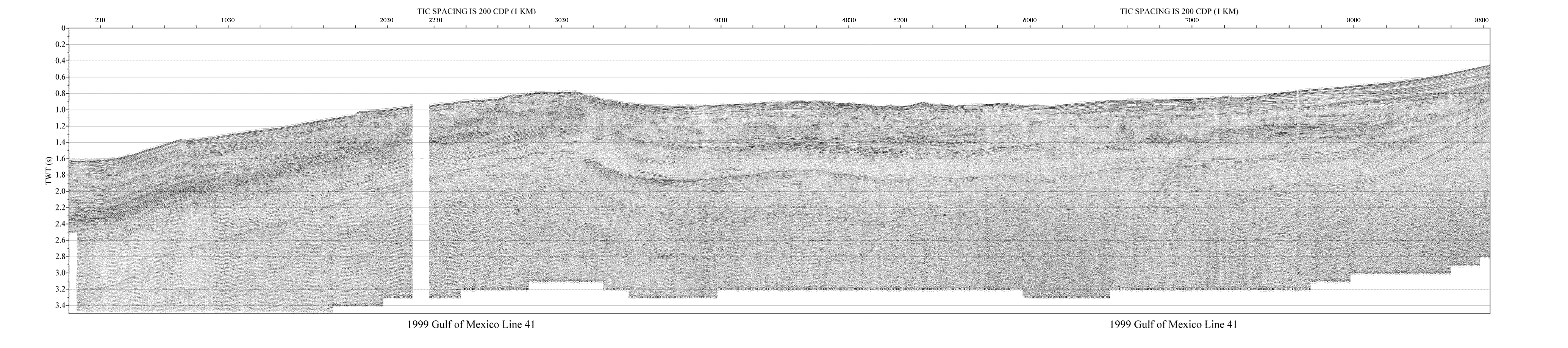
This report consists of two-dimensional marine seismic reflection profile data from the northern Gulf of Mexico. These data were acquired in 1998 and 1999 with the Research Vessels Tommy Munro (M1-98-GM) and Gyre (G1-99-GM). The data are available in binary and GIF image formats. Binary data are in Society of Exploration Geologists (SEG) SEG-Y format and may be downloaded for further processing or display. Reference maps and GIF images of the profiles may be viewed with your Web browser.
Purpose:
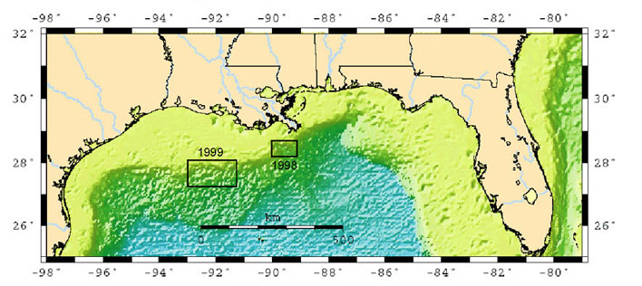
Marine seismic reflection data are used to image and map sedimentary and structural features of the seafloor and subsurface. These data were acquired across the upper and middle continental slope of the northern Gulf of Mexico as part of an investigation of the of the seismic character, distribution, and potential effects of naturally-occurring marine gas hydrates and related free gas within the gas hydrate stability zone. The specific objectives of this investigation are (a) to produce high-resolution images of the gas hydrate stability zone; (b) to study the distribution and character of potential seafloor failures and their relationship to known and inferred gas hydrate deposits; (c) to look at systematic variations in subsurface structure in gas hydrate and non-hydrate areas; and (d) to estimate, if possible, the amounts of hydrates present within the gas hydrate stability zone. The seismic profiles provide high-quality images with approximately 5 meters of vertical resolution and up to 2 km of penetration.
Supplemental_Information:
Multichannel seismic reflection profiles are acquired by means of an acoustic source (usually compressed air discharged via an air gun or water gun), and a hydrophone array. Both elements are typically towed in the water behind a survey vessel. The sound source emits a short acoustic pulse, which propogates through the water and sediment columns. The acoustic energy is reflected at density boundaries (such as the seafloor or sediment layers beneath the seafloor), and detected at the hydrophone. As the vessel moves, this process is repeated at intervals ranging between 10 and 30 meters depending on the source type. In this way a two-dimensional image of the geologic structure beneath the ship track is constructed. Additional information about the USGS surveys M1-98-GM and G1-99-GM are available at http://walrus.wr.usgs.gov/infobank/m/m198gm/html/m-1-98-gm.meta.html. The data window for M1-98-GM is -89.941 28.024 -88.995 28.656 (decimal degrees). http://walrus.wr.usgs.gov/infobank/g/g199gm/html/g-1-99-gm.meta.html . The data window for G1-99-GM is -92.991 27.368 -91.429 27.944 (decimal degrees). For additional information on the field activities, see the following field activity pages: https://cmgds.marine.usgs.gov/fan_info.php?fan=M198GM and https://cmgds.marine.usgs.gov/fan_info.php?fan=1999-002-FA .
Time_Period_of_Content:
Time_Period_Information:
Multiple_Dates/Times:
Single_Date/Time:
Calendar_Date: 1998
Single_Date/Time:
Calendar_Date: 1999
Currentness_Reference:
Ground condition. Data assumed to be constant over time, but may change due to geologic processes. The actual dates of the cruise based on the field activity page (better representation of data acquisition dates) are as follows: June 6-20, 1998 and April 9-22, 1999.
Status:
Progress: Complete
Maintenance_and_Update_Frequency: None planned
Spatial_Domain:
Bounding_Coordinates:
West_Bounding_Coordinate: -93.00
East_Bounding_Coordinate: -89.00
North_Bounding_Coordinate: +28.67
South_Bounding_Coordinate: +27.37
Keywords:
Theme:
Theme_Keyword_Thesaurus: USGS Metadata Identifier
Theme_Keyword: USGS:4d7d9946-e02a-4fb6-96cc-5dab6e6eb958
Theme:
Theme_Keyword_Thesaurus: USGS Thesaurus
Theme_Keyword: marine geophysics
Theme_Keyword: seismic reflection methods
Theme_Keyword: gas hydrate resources
Theme_Keyword: sea-floor characteristics
Theme_Keyword: geospatial datasets
Theme_Keyword: navigational data
Theme:
Theme_Keyword_Thesaurus: none
Theme_Keyword: marine seismic reflection
Theme_Keyword: gas hydrate
Theme_Keyword: air gun
Theme_Keyword: water gun
Theme_Keyword: multichannel
Theme_Keyword: SEG-Y
Theme_Keyword: M1-98-GM
Theme_Keyword: G1-99-GM
Theme:
Theme_Keyword_Thesaurus: ISO 19115 Topic Category
Theme_Keyword: geoscientificInformation
Place:
Place_Keyword_Thesaurus: none
Place_Keyword: Northern Gulf of Mexico
Place_Keyword: Mississippi Canyon
Access_Constraints: None. These data are held in the public domain.
Use_Constraints:
The U.S. Geological Survey requests to be acknowledged as the originator of the data in future products or derivative research.
Point_of_Contact:
Contact_Information:
Contact_Person_Primary:
Contact_Person: Patrick E. Hart
Contact_Organization: U.S. Geological Survey
Contact_Position: geophysicist
Contact_Address:
Address_Type: mailing address
Address: Mail Stop 999, 345 Middlefield Rd.
City: Menlo Park
State_or_Province: CA
Postal_Code: 94025
Country: USA
Contact_Voice_Telephone: (650) 329-5160
Contact_Electronic_Mail_Address: hart@usgs.gov
Browse_Graphic:
Browse_Graphic_File_Name: https://pubs.usgs.gov/of/2002/of02-368/images/cruisemap.jpg
Browse_Graphic_File_Description:
Map of Northern Gulf of Mexico showing areas of USGS seismic research cruises, 708x316 pixels, 73k bytes
Browse_Graphic_File_Type: JPEG
Browse_Graphic:
Browse_Graphic_File_Name: https://pubs.usgs.gov/of/2002/of02-368/images/99gif/41.gif
Browse_Graphic_File_Description:
Gulf of Mexico seismic line 41.gif (water-gun source), 4139x921 pixels, 424k bytes
Browse_Graphic_File_Type: GIF
Cross_Reference:
Citation_Information:
Originator: Alan K. Cooper
Originator: Patrick E. Hart
Publication_Date: 2002
Title:
High-resolution seismic-reflection investigation of the northern Gulf of Mexico gas-hydrate-stability zone
Publication_Information:
Publication_Place: Great Britain
Publisher: Elsevier Sciences, Ltd
Cross_Reference:
Citation_Information:
Originator: Alan K. Cooper
Originator: Patrick E. Hart
Originator: Ingo Pecher
Publication_Date: 1998
Title:
Cruise report for a seismic investigation of gas hydrates in the Mississippi Canyon region, northern Gulf of Mexico - Cruise M1-98-GM
Series_Information:
Series_Name: U.S. Geological Survey Open-File Report
Issue_Identification: 98-506
Publication_Information:
Publication_Place: Menlo Park, CA
Publisher: U. S. Geological Survey
Online_Linkage: https://doi.org/10.3133/ofr98506
Online_Linkage: https://pubs.er.usgs.gov/publication/ofr98506
Cross_Reference:
Citation_Information:
Originator: Alan K. Cooper
Originator: David Twichell
Originator: Patrick E. Hart
Publication_Date: 1999
Title:
A seismic-reflection investigation of gas-hydrates and sea-floor features of the upper continental slope of the Garden Banks and Green Canyon regions, northern Gulf of Mexico: Report for cruise G1-99-GM (99002)
Series_Information:
Series_Name: U.S. Geological Survey Open-File Report
Issue_Identification: 99-570
Publication_Information:
Publication_Place: Menlo Park, CA
Publisher: U. S. Geological SurveyCross_Reference
Online_Linkage: https://pubs.er.usgs.gov/publication/ofr99570
Online_Linkage: https://doi.org/10.3133/ofr99570
Cross_Reference:
Citation_Information:
Originator: Myung Lee
Originator: Patrick E. Hart
Originator: Warren Agena
Publication_Date: 2000
Title:
Processing strategy for water-gun seismic data from the Gulf of Mexico
Series_Information:
Series_Name: U.S. Geological Survey Bulletin
Issue_Identification: 2181
Publication_Information:
Publication_Place: Denver, CO
Publisher: U. S. Geological Survey
Online_Linkage: https://pubs.usgs.gov/bul/b2181/
Online_Linkage: https://doi.org/10.3133/b2181
Data_Quality_Information:
Attribute_Accuracy:
Attribute_Accuracy_Report:
The validity or accuracy of marine seismic reflection profiles is highly qualitative, and depends on equipment and operating condition variables too numerous to quantify. There have been no efforts to assess the validity of the data.
Logical_Consistency_Report: These data have not been assessed for internal consistency.
Completeness_Report:
These are sparse line coverages (2D). Therefore, data are inherently incomplete. Geologic details between lines must be inferred. The surveys were not designed to cover a particular geographic area; the line spacings and azimuths were chosen to assess geologic features related to known and inferred gas hydrate deposits.
Positional_Accuracy:
Horizontal_Positional_Accuracy:
Horizontal_Positional_Accuracy_Report:
Positions were determined with differential Global Positioning System (GPS). Absolute position accuracy was approximately ± 10 m.
Vertical_Positional_Accuracy:
Vertical_Positional_Accuracy_Report:
The vertical position was local sea level and there has been no corrections to a datum or for tidal variations.
Lineage:
Process_Step:
Process_Description:
1998 multichannel seismic data acquisition: Acquisition and recording of air-gun and water-gun seismic reflection data. The source consisted of either a 35/35 cubic inch dual-chamber GI ("Generator-Injector") air gun or a 15 cubic inch water gun. The "injector" chamber of the GI gun was timed to discharge a short time (typically 20-30 msec) after the "generator" chamber so as to suppress the bubble pulse and create an optimal signal. The streamer was 240 meters in length with a 10-meter group interval (three hydrophones per group), and was manufactured by Innovative Transducers, Inc. (ITI) with solid-core construction and "thin-film" cylindrical hydrophones of polyvinylidene fluoride (PVDF) plastic. A problem with a streamer connection caused the far 7 channels to be very noisy, and these channels were eliminated during data processing. Data were digitized with the Geometrics Strataview seismograph and recorded with the Geometrics Marine Controller in SEG-D format.
Process_Date: 1998
Process_Step:
Process_Description:
1999 multichannel seismic data acquisition: The multichannel data acquisition equipment and parameters in 1999 were the same as 1998 except the 15 cubic inch water-gun source was used on all lines, and the recording problem with the far 7 streamer channels was corrected.
Process_Date: 1999
Process_Step:
Process_Description:
Multichannel data processing: A representative data processing sequence consisted of:
1. SEG-D input and resample to 0.5 millisecond
2. Trace edit
3. Geometry assignment
4. 50 Hz low-cut filter
5. Water-bottom mute
6. Deep-water recording delay correction
7. Spherical divergence correction
8. Noise-spike editing
9. FK filter
10. Deconvolution
11. Common midpoint (CMP) sort
12. Stacking velocity analysis
13. Normal move-out correction
14. Stack
15. SEG-Y output
16. 60-320 Hz bandpass filter
17. Whole-trace balance
18. gif image file output
Process_Date: 1999
Process_Step:
Process_Description:
Positional (navigation) data: As the seismic reflection data were acquired, the position of the vessel was continuously determined with the differnetial Global Positioning System (GPS). GPS positions were recorded approximately every second, and written to an ASCII file. This file was subsequently used to determine the position of each seismic reflection "shotpoint". This processing occurred in 199806 and 199904, with the process date reflecting the most recent of those.
Process_Date: 199904
Process_Step:
Process_Description:
The data were plotted in 8-bit gray scale representation to Postscript files using the Seismic Unix 'psimage' algorithm at a scale of 0.15 seconds per inch and 75 traces per inch. The Postscript images were then converted to GIF with Aladdin Ghostview v5.50.
Process_Date: 2001
Process_Contact:
Contact_Information:
Contact_Person_Primary:
Contact_Person: Patrick E. Hart
Contact_Organization: U.S. Geological Survey
Contact_Position: geophysicist
Contact_Address:
Address_Type: mailing address
Address: Mail Stop 999, 345 Middlefield Rd.
City: Menlo Park
State_or_Province: CA
Postal_Code: 94025
Country: USA
Contact_Voice_Telephone: (650) 329-5160
Contact_Electronic_Mail_Address: hart@usgs.gov
Process_Step:
Process_Description: Creation of original metadata record
Process_Date: 20020916
Process_Contact:
Contact_Information:
Contact_Person_Primary:
Contact_Person: Patrick E. Hart
Contact_Organization: U.S. Geological Survey
Contact_Position: geophysicist
Contact_Address:
Address_Type: mailing address
Address: Mail Stop 999, 345 Middlefield Rd.
City: Menlo Park
State_or_Province: CA
Postal_Code: 94025
Country: USA
Contact_Voice_Telephone: (650) 329-5160
Contact_Electronic_Mail_Address: hart@usgs.gov
Process_Step:
Process_Description:
Peter Schweitzer made improvements to the metadata file for inclusion into GEO-NSDI web accessible folder. Upon inspection, some of the improvements he made include: added the USGS Thesaurus and appropriate terms, added the ISO Topic Categories thesaurus and appropriate term, updated/added the publication online links (citation and cross-references), updated the browse graphic link, added a direction spatial reference method (removing the indirect spatial reference), added an entity and attribute overview description, added additional digital formats and network resource names.
Process_Date: 20160610
Process_Contact:
Contact_Information:
Contact_Person_Primary:
Contact_Person: Peter N Schweitzer
Contact_Organization: USGS Midwest Area
Contact_Position:
Collection manager, USGS Geoscience Data Clearinghouse, http://geo-nsdi.er.usgs.gov/
Contact_Address:
Address_Type: mailing address
Address: Mail Stop 954 12201 Sunrise Valley Dr
City: Reston
State_or_Province: VA
Postal_Code: 20192-0002
Country: USA
Contact_Voice_Telephone: 703-648-6533
Contact_Facsimile_Telephone: 703-648-6252
Contact_Electronic_Mail_Address: pschweitzer@usgs.gov
Process_Step:
Process_Description:
Edits to the metadata were made to fix any errors that MP v 2.9.50 flagged. This is necessary to enable the metadata to be successfully harvested for various data catalogs. Minor edits to the structure of the metadata were performed such as removing extra carriage returns. The DOI link was added to the identification section as well as to some cross-references. Added additional USGS Thesaurus terms. Added the links to the field activities related to these data. Updated the currentness reference to more accurately describe the range of dates and data. No attempt was made to add detailed entity and attribute information specific to the data. The user will need to reference the original Open-File Report for that information. Added access instructions for the online resources. The metadata date (but not the metadata creator - which Peter set to himself) was edited to reflect the date of these changes. The metadata available from a harvester may supersede metadata bundled within a download file. Compare the metadata dates to determine which metadata file is most recent. Additional edits were probably made to the original metadata by someone else who did not document what they changed (20210408). Tweaked a thesaurus name (20211117).
Process_Date: 20211117
Process_Contact:
Contact_Information:
Contact_Organization_Primary:
Contact_Organization: U.S. Geological Survey
Contact_Person: VeeAnn A. Cross
Contact_Position: Marine Geologist
Contact_Address:
Address_Type: Mailing and Physical
Address: 384 Woods Hole Road
City: Woods Hole
State_or_Province: MA
Postal_Code: 02543-1598
Contact_Voice_Telephone: 508-548-8700 x2251
Contact_Facsimile_Telephone: 508-457-2310
Contact_Electronic_Mail_Address: vatnipp@usgs.gov
Spatial_Data_Organization_Information:
Direct_Spatial_Reference_Method: Point
Point_and_Vector_Object_Information:
SDTS_Terms_Description:
SDTS_Point_and_Vector_Object_Type: Entity point
Spatial_Reference_Information:
Horizontal_Coordinate_System_Definition:
Geographic:
Latitude_Resolution: 0.00001
Longitude_Resolution: 0.00001
Geographic_Coordinate_Units: decimal degrees
Geodetic_Model:
Horizontal_Datum_Name: WGS 84
Ellipsoid_Name: WGS 84
Semi-major_Axis: 6378137
Denominator_of_Flattening_Ratio: 298.257
Entity_and_Attribute_Information:
Overview_Description:
Entity_and_Attribute_Overview:
Binary data file: Each profile is available as a binary file in Society of Exploration Geophysicists SEG-Y format. A SEG-Y file consists of 1) a 3200-byte file identification record of EBCDIC encoded general information; 2) a 400-byte binary record with information such as sample rate and record length specific to the data set; and 3) multiple records, one seismic reflection trace per record. Each trace record is preceded by a 240-byte "trace header" containing information such as trace number and acquisition day and time specific to each trace. The trace data are represented as a time series of unitless 16-bit integer or 32-bit real numbers proportional to the pressure recorded at each hydrophone. The SEG-Y file is useful only if you have access to specialized software designed to process and display seismic reflection data.
Entity_and_Attribute_Detail_Citation:
Barry, K.M., Cavers, D.A., and Kneale, C.W., 1975, Recommended standards for digital tape formats: Geophysics, v. 40, n. 2, p. 344 - 352. Also available online at: http://www.seg.org/Portals/0/SEG/News%20and%20Resources/Technical%20Standards/seg_y_rev1.pdf
Distribution_Information:
Distributor:
Contact_Information:
Contact_Person_Primary:
Contact_Person: Patrick E. Hart
Contact_Organization: U.S. Geological Survey
Contact_Position: geophysicist
Contact_Address:
Address_Type: mailing address
Address: Mail Stop 999, 345 Middlefield Rd.
City: Menlo Park
State_or_Province: CA
Postal_Code: 94025
Country: USA
Contact_Voice_Telephone: (650) 329-5160
Contact_Electronic_Mail_Address: hart@usgs.gov
Resource_Description: USGS Open-File Report 02-368
Distribution_Liability:
This dataset was prepared by an agency of the United States Government. Neither the United States Government nor any agency thereof nor any of their employees, make any warranty, expressed or implied, or assumes any legal liability or responsibility for information, apparatus, products, or processes disclosed in this report, nor represents that its use would not infringe privately owned rights. Reference herein to any specific commercial product, process, or service by trade name, trademark, manufacturer, or otherwise does not constitute or imply its endorsement, recommendation, or favoring by the United States Government or any agency thereof. Although all data published on this CD-ROM have been used by the USGS, no warranty, expressed or implied, is made by the USGS as to the accuracy of the data and related materials. The act of distribution shall not constitute any such warranty, and no responsibility is assumed by the USGS in the use of this data.
Standard_Order_Process:
Digital_Form:
Digital_Transfer_Information:
Format_Name: SEG-Y
Format_Version_Date: 1975
Format_Information_Content: Binary seismic reflection data
Transfer_Size: 7168
Digital_Transfer_Option:
Online_Option:
Computer_Contact_Information:
Network_Address:
Access_Instructions:
The links point to data catalog pages where the individual files can be downloaded.
Digital_Form:
Digital_Transfer_Information:
Format_Name: GIF
Format_Version_Number: 89a
Format_Information_Content:
Seismic sections rendered in gray-scale, two-way travel- time on the vertical axis, distance on horizontal (images are about 1000 pixels high and vary from 1000 to 3000 pixels in width)
Transfer_Size: 13
Digital_Transfer_Option:
Online_Option:
Computer_Contact_Information:
Network_Address:
Access_Instructions:
The links point to data catalog pages where the individual files can be downloaded.
Digital_Form:
Digital_Transfer_Information:
Format_Name: Columnar text
Format_Version_Number: unspecified
Format_Specification: Tab-delimited, field labels on first row
Format_Information_Content:
These ASCII files contain columns listing line number, CDP number, latitude and longitude in decimal degrees and UTM coordinates CDP stands for Common Depth Point and each seismic trace along a profile has a unique CDP number and are located at 5 meter intervals. Locations are listed for every 20th to 40th CDP along each profile. Interpolation of locations between listed CDPs would be necessary to obtain coordinates for every CDP. CDP locations are not listed in the SEG-Y seismic trace headers.
Transfer_Size: 0.4316
Digital_Transfer_Option:
Online_Option:
Computer_Contact_Information:
Network_Address:
Access_Instructions:
The links point to data catalog pages where the individual files can be downloaded.
Fees: none
Technical_Prerequisites:
Use of SEG-Y data requires specialized software, such as ProMax and Seisworks by Landmark Geophysical; FOCUS and SeisX by Paradigm Geophysical; SPW by Parallel Geoscience; or VISTA by Seismic Image Software.
Metadata_Reference_Information:
Metadata_Date: 20240318
Metadata_Contact:
Contact_Information:
Contact_Person_Primary:
Contact_Person: Peter N Schweitzer
Contact_Organization: USGS Midwest Area
Contact_Position:
Collection manager, USGS Geoscience Data Clearinghouse, http://geo-nsdi.er.usgs.gov/
Contact_Address:
Address_Type: mailing address
Address:
Mail Stop 954
12201 Sunrise Valley Dr
City: Reston
State_or_Province: VA
Postal_Code: 20192-0002
Country: USA
Contact_Voice_Telephone: 703-648-6533
Contact_Facsimile_Telephone: 703-648-6252
Contact_Electronic_Mail_Address: whsc_data_contact@usgs.gov
Contact_Instructions:
The metadata contact email address is a generic address in the event the person is no longer with USGS. (updated on 20240318)
Metadata_Standard_Name: Content Standard for Digital Geospatial Metadata
Metadata_Standard_Version: FGDC-STD-001-1998

This page is <https://cmgds.marine.usgs.gov/catalog/whcmsc/open_file_report/ofr2002-368/ofr02-368.html>
Generated by mp version 2.9.51 on Mon Mar 25 16:05:20 2024