Tsunami deposit data and sediment transport models from the Salmon River estuary, central Oregon
By SeanPaul M. La Selle, Alan Nelson, Robert C. Witter, Guy R. Gelfenbaum, Jason S. Padgett, and Bruce E. Jaffe
https://doi.org/10.5066/P9M86S7D
Dates
Published: April 17, 2024
Data Collected: Sept. 2, 1987 – May 15, 2018
Summary
This data release contains sedimentological data and numerical models representing the circa 1700 CE tsunami in the Salmon River estuary, Oregon. The thickness of sandy tsunami deposits was identified in hundreds of cores that map the extent of the deposit throughout the estuary. Grainsize data demonstrate the inland fining of the sandy tsunami deposits. The distribution of tsunami deposits was used to test numerical models of tsunami sediment transport and hypothetical earthquake sources representing megathrust rupture in the Cascadia Subduction Zone.
Environmental Data
-
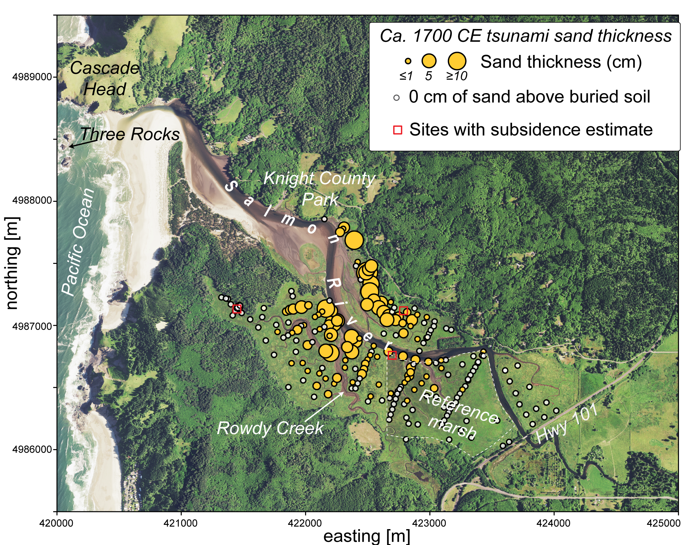
Thickness distribution of the most recent sandy tsunami deposit in the Salmon River estuary, Oregon
This portion of the data release provides the spatial thickness distribution of sandy deposits inferred to have been deposited at the Salmon River, OR by a circa 1700 CE tsunami. Data were collected by describing hand-operated gouge cores at 129 sites in 2017 and 2018, and supplemented by 114 core descriptions from 1987 (Nelson and others, 2004).
Data Files
salmonriver_thickness.csv - 15.6 KB
Metadata Files
salmonriver_thickness_metadata.xml - 20.9 KB
salmonriver_thickness_metadata.txt - 20.4 KB
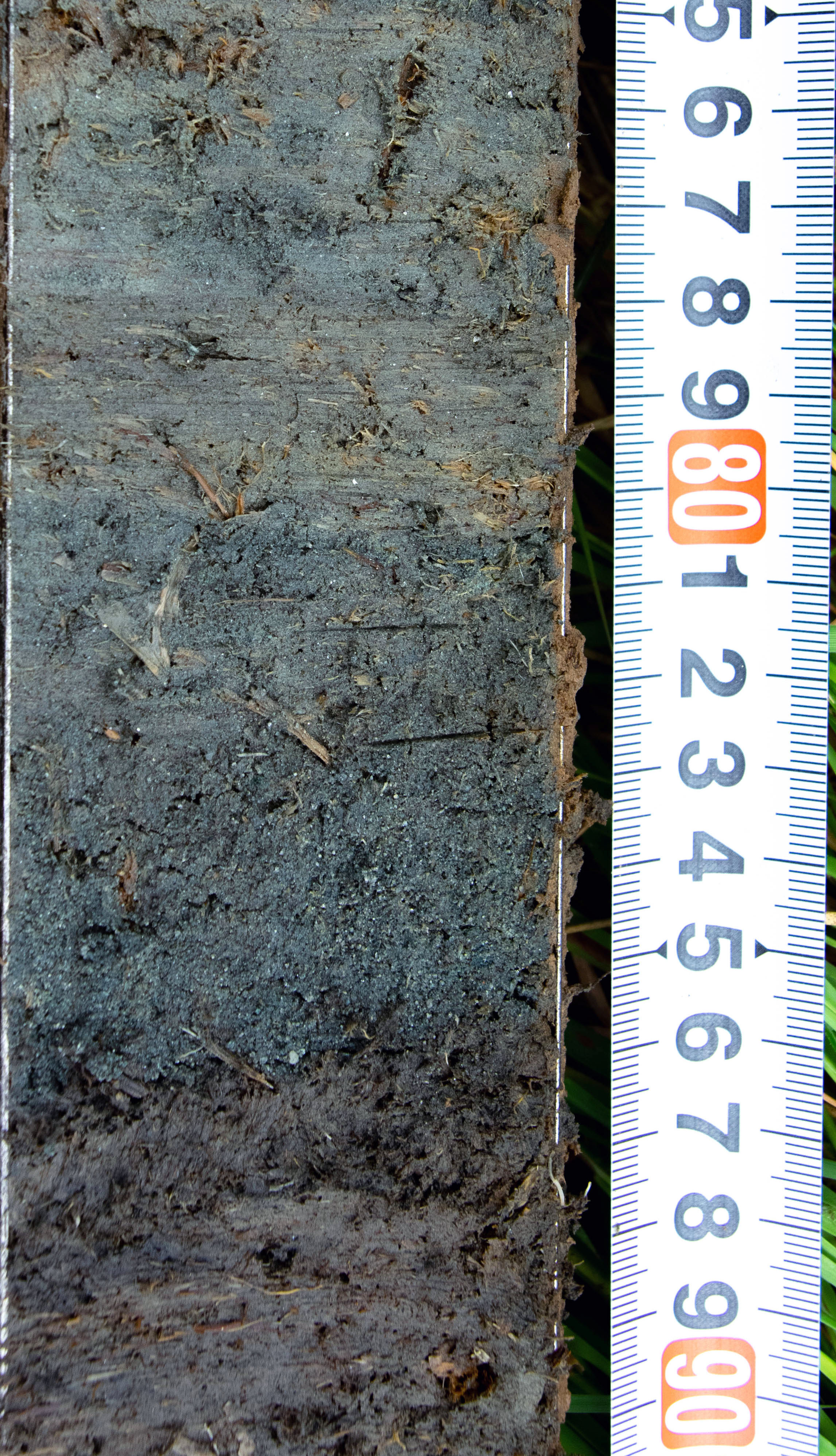
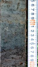 Photo of the buried soil, tsunami sand, and post-tsunami tidal silt from a core in the Salmon River estuary, OR.
 -
Sediment grain-size distributions from cores collected in the Salmon River estuary, Oregon
This portion of the data release presents sediment grain-size data from cores and surface samples collected from the Salmon River estuary in 2017 and 2018. In total, 60 samples were collected from 18 sites containing sandy sediment from the circa 1700 CE tsunami deposit, two sites with post-1700 CE silt, and eight modern surface sample sites. The grain-size distributions of samples were determined using standard techniques developed by the USGS Pacific Coastal and Marine Science Center sediment lab. The grain-size data are provided in a comma-separated values (.csv) text file.
Data Files
salmonriver_grainsize.csv - 34.6 KB
Metadata Files
salmonriver_grainsize_metadata.xml - 50.6 KB
salmonriver_grainsize_metadata.txt - 49.5 KB
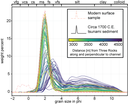 Grainsize distributions of tsunami sediments from the Salmon River estuary, OR.

Simulation Data
-
Hydrodynamic and sediment transport tsunami models at the Salmon River estuary, Oregon
This portion of the USGS data release describes the Delft3D-FLOW model application for propagating simulated tsunamis from 15 hypothetical earthquake sources of the Cascadia Subduction Zone through a series of nested grids to modeling tsunami sediment transport in the Salmon River estuary, OR. Input files necessary to run the Delft3D-FLOW model are provided.
The model application was constructed using Delft3D-FLOW. Zip files containing model setup data are provided for each of the nested hydrodynamic grids at 1650 m, 400 m, and 50 m horizontal resolution. The fully three-dimensional sediment transport model at about 10 m resolution contains boundary condition files from the nested hydrodynamic grids for each of the earthquake scenarios, as well as bathymetry files reflecting different amounts of coseismic subsidence associated with the earthquake scenarios and adjusted to either Mean Low Water (MLW) hindcast for the 1700 CE earthquake or Mean Higher High Water (MHHW). Each zip file contains an example model run for the DOGAMI L3 earthquake source on each respective grid. These examples can be used as templates to run the other earthquake scenarios that are provided.Data Files
salmonriver_delft3d_10m.zip - 16.5 GB
salmonriver_delft3d_1650m.zip - 43.9 MB
salmonriver_delft3d_400m.zip - 28.2 MB
salmonriver_delft3d_50m.zip - 4.9 GB
Metadata Files
salmonriver_delft3d_metadata.xml - 24.4 KB
salmonriver_delft3d_metadata.txt - 23.5 KB
Support Files
salmonriver_delft3d_supportfile.pdf - 161.3 KB
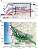 a)Delft3D-FLOW hydrodynamic nested grids, with an example of deformation from a hypothetical Cascadia megathrust earthquake scenario. b) The 10 m sediment transport grid.
Related Field Activities
- 2017-643-FA - View Details
- 2018-625-FA - View Details
Suggested Citation
La Selle, S.M., Nelson, A.R., Witter, R.C., Jaffe, B.E., Gelfenbaum, G., Padgett, J.S., 2024, Tsunami deposit data and sediment transport models from the Salmon River estuary, central Oregon: U.S. Geological Survey data release, https://doi.org/10.5066/P9M86S7D.
Salmon River estuary, OR