
Tina M. Niemi1, Robert Kayen2, Hongwei Zhang1 Christopher R. Dunn1, David M. Doolin3
1University of Missouri-Kansas City, Dept. of Geosciences, Kansas City, MO
2U.S. Geological Survey, MS999, 345 Middlefield Road, Menlo Park, CA 94025
3Department of Civil and Environmental Engineering, University of California at Berkeley, Berkeley, CA

|
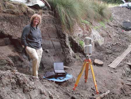
Tripod-mounted LiDAR system at the Vedanta Ranch trench. This poster documents our efforts to precisely record the location, morphology, and image of two trench study sites on the San Andreas fault. We use ground-based LiDAR to preserve records of the trenches and exposed fault breaks in soil. Substitute-color analysis is being used to enhance and extract details of the fault break not visible in natural color and light intensity. Point cloud filtering techniques are used to ‘de-vegetate’ the modern landscape so we can view the ‘bald’ scarp as G.K. Gilbert did in 1906 |
|||||||
|
Abstract | Vedanta Ranch Trench | Color Channel & Intensity Models of the Trench Wall | Olema Ridge Trench | Summary
|
||||||||
geotech/olema/index.html
contact: Robert Kayen
last modified 2018


