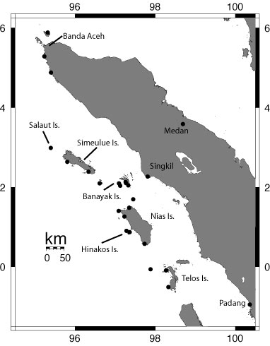
Leg 1 of Sumatra tsunami survey is completed. The map shows sites visited by the first leg. We surveyed more than 20 sites in the Batu Islands, Nias, Banyak Islands, Simeulue, Salaut, and the Sumatran mainland. We will meet up with leg 2 of the survey at Sabang on Pulau Wei, an island north of Banda Aceh. Leg 2 will continue the survey, traveling south from Banda Aceh to Padang. Map courtesy of Jose Borrero, USC.
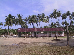
 Photos of Lhokkruet 10 April 2005 (see map)
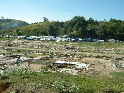
Lhokkruet, approximately 75 km south of Banda Aceh, was hit hard by the 26 December 2004 tsunami. Subsidence was evident on the beach, where the shoreline was reported to have moved ~200 m landward. Most of the town was destroyed. The line where vegetation had been removed by the tsunami was up to 13 m above the coastal plane and debris was found in trees 14 meters above the ground.
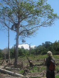
Measuring height of palm fronds in tree. Debris in trees indicate that flow depth was at least 14 meters above the ground. Photograph taken by Lukiyanto, Indonesian Natural Resources Inventory technology Research Center - BPPT.
Report from Bob Peters, USGS, via satellite phone at 8:00 pm 9 April 2005 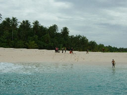
Salaut, 2 islands 35 km north of the northern tip of Simeulue, 9 April 2005. We were at the larger island. The northeast corner of the island had a steep sandy beach. Uplift was evident around the entire island. The 26 December 2004 tsunami inundated more than 175 meters from the present shoreline into the jungle. Debris was found 1.5 up in trees on a terrace 4.5 meters above present sea level. There is a 2 meter high erosional scarp on the east side of the island. Tsunami deposits extend beyond the scarp into the jungle.
The team went ashore at two locations on 9 April. At the fishing village of Kariya Vhapi on the NW shore of Simuelue, the 28 March tsunami overtopped a 3.2 m high berm. It did not damage the village. The 26 December tsunami was larger, approximately 2 m high when it went through the village, and completely destroyed all buildings. The village, which is approximately 20 km south of the north tip of Simeulue Island, has already been rebuilt.
Later in the day, the US scientists on the team swam ashore at Salaut Islands, which is located approximately 15 to 20 nautical miles north of Simeulue Island. They swam ashore because there was not a location to allow the 26-foot speedboat close enough for them to wade ashore. When on Simeulue Island, the team heard rumors that one of the islands in the Salaut group had split apart during the 28 March earthquake. The rumors turned out to be just rumors— all the islands were intact. The 28 March tsunami was small on Salaut Island— it did not overtop the berm at the beach, which is 2 m high. The 26 December tsunami inundated more than 250 m and run-up was 4 to 5 m. Coral boulders were transported onshore by the 26 December tsunami. There was evidence of approximately 2 m of uplift here, primarily from the 26 December 2004 earthquake. Heavy rains yesterday made work difficult. Today there were spotty, heavy rain showers. The team is motoring for Sumatra, where it will focus on documenting water levels and tsunami sand deposits from the 26 December 2004 tsunami.
People are afraid of another tsunami and are leaving the islands. The team is letting everyone that they meet know that a large tsunami in this area is very, very unlikely in the near future.
Report from Bob Peters, USGS, via satellite phone at
9:00 pm 8 April 2005 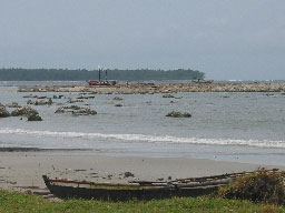
Busung, Gusong Bay, Simeulue, Indonesia, 8 April 2005. Fishing boats stranded on reef. Reef uplifted approximately 1.5 meters above presest sea level from 28 March 2005 earthquake. Earlier reports suggested 0.5 m subsidence after 26 December 2004 earthquake. The 26 December tsunami was larger than 28 March tsunami. Run-up from the 26 December 2004 tsunami was measured at 3.2 m on the south side of the bay. Inundation was estimated to be approximately 100 meters here and approximately 250 m at the head of the bay. Photograph taken by Lukiyanto, Indonesian Natural Resources Inventory technology Research Center - BPPT.
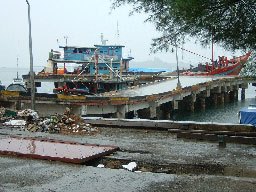
Sinabang, capital of Simeulue Island, Indonesia, 8 April 2005. Early reports suggested that Sinabang was devastated by the 28 March 2005 earthquake. On 8 April 2005 the team went ashore at Busung on the SW coast of Simeulue. Gegar, Rahman, Widjo, Brian, and Vasily went to Sinabang to assess the damage. Sinabang, which only sustained minor damage from the 26 December 2004 earthquake, was significantly affected by the 28 March 2005 earthquake. The earthquake and subsequent fire destroyed 50-60 percent of the downtown area. The port facility was also significantly damaged. The earthquake produced 40 cm of uplift at Sinabang. There was no tsunami from the 28 March 2005 earthquake at Sinabang. The photo shows earthquake damage to the port facility. Photograph taken by Widjokongko, Indonesian Tsunami Research Center/Coastal Dynamic Research Center - BPPT
The 28 March tsunami was large at Gusong Bay in SW Simeulue Island. The team measured tsunami runup of 4.2 m and inundation distances of approximately 150 m at a surf camp (see reports by Bill Sharp, Sumatra Surfzone Relief Operation, and Brian Williams, camp owner). Bill Sharp's report includes a description of the 28 March tsunami by Ranu, Surfguide, as "A white fence of fire", and "Sounded like many Buffalo running." Uplift was large here, about 1.5 m, and exposed reefs. The uplift acted as a natural buffer to the 28 March tsunami, decreasing its height and the distance it traveled inland. The debris line from the 26 December tsunami is farther inland than the one from the 28 March tsunami. Gegar Prasetya and Rahman Hidayat (Indonesian Tsunami Research Center/Coastal Dynamic Research Center - BPPT) are staying on Simeulue Island where they need to do additional surveys. The rest of the team will take measurements on NW Simeulue tomorrow and then transit to the main island of Sumatra for additional fieldwork.
Report from Bob Peters (USGS), Jose Borrero (USC), and Vasily Titov (NOAA) via satellite phone at 8:45 pm 7 April 2005 (1345 7 April UTC)At Bangkuru Island, the westernmost island of the Banyak group, the 28 March 2005 tsunami flowed 100 to 200 m into a dense jungle. Tsunami flow depths were 1 to 2 m as it entered the jungle. Fresh sand brought by the tsunami was plastered on the seaward side of tree trunks up to approximately 1 m above ground level. There was no evidence of the 26 December 2004 tsunami at this location. Note: tsunami wave heights were not as large as expected in the Banyak Islands.
Later in the day on 7 April, the team went onshore at Babi Island, which is located between Bangkuru Island and Simeulue Island. The 28 March 2005 tsunami broke branches 2 m up in trees on a 1.5 m high berm. The tsunami inundated 200 m across a mangrove swamp, leaving a sand deposit on its surface. There was approximately 80 cm of uplift on Babi Island. This uplift raised the mangrove swamp above the tide level, leaving it high and dry. Uplift also exposed reefs. The team is headed to SW Simeulue Island where it will take measurements at Teluk Gusong.
Report from Bob Peters (USGS), Bretwood Higman (UW), and Gegar Prasetya (BPPT) via satellite phone at 7:30 pm 6 April 2005 (1230 6 April UTC)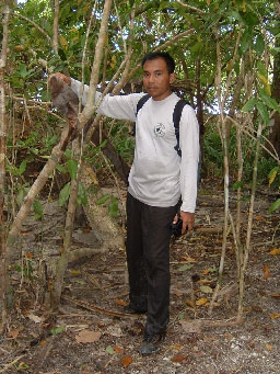
Tuangku Island, Banyak Islands, Indonesia 6 April 2005. Lukiyanto (Indonesian Natural Resources Inventory technology Research Center - BPPT) measuring height of tsunami debris. The tsunami inundated more than 200 meters inland. Flow depths were approximately 2 meters and run-up was approximately 3 meters above present sea level. Tsunami deposit with two distinct layers indicates at least two waves. On SW Tuangku, the team did not see evidence for uplift or subsidence. Farther north, there was approximately 0.3 meter subsidence. Photograph taken by Widjokongko, Indonesian Tsunami Research Center/Coastal Dynamic Research Center - BPPT.
Tsunami deposits at Tuangku Island recorded two waves from the 28 March tsunami. Run-up elevations were 2 to 3 m above sea level at the time the tsunami arrived. On northern Tuangku, the tsunami went into a dense jungle and the team was not able to measure maximum inundation distances because they could not get through the jungle. Tsunami flow depths were greater than 2 m near the shore. Subsidence was hard to estimate, but the island appeared to have subsided, perhaps by 0.5 m or less. The team heard reports that the tsunami was about 3 m on the backside (eastern side) of Tuangku at Sialit, but did not verify these reports because put taking measurements on Bangkuru Island, the westernmost island in the Banyak group, as a higher priority. The loss of use of the 16' dingy is limiting the locations where the team can go ashore. The team carefully chooses their landing spots. They are improvising by wading, using a small kayak from the Seimoa, and using an small inflatable raft that Bretwood Higman brought to get to shore. The team is now motoring to Bangkuru, where they will go ashore in the morning to take measurements.
Report from Bob Peters, USGS, via satellite phone at 6:45 am 6 April 2005 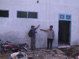
Singkil, Sumatra, Indonesia. 5 April 2005. Singkil resident showing watermark from tsunami 1.5 m above ground on building at Singkil harbor, measured by Rahman Hidayat ( Indonesian Tsunami Research Center/Coastal Dynamic Research Center - BPPT). Subsidence was clearly evident at Singkil. A piling formerly on the beach is now 100 meters from shore. Part of the main street in town was under water up to 0.5 meters deep. Photograph taken by Bob Peters, USGS.
Many houses are flooded in the town of Singkil because of subsidence from the 28 March earthquake. Roads near the coast are 1/3 to 1/2 m underwater. Locals reported that the 28 March tsunami arrived 10 to 15 minutes after the earthquake and came as one large surge that stayed for almost an hour. The team measured watermark elevations that are 1.5 to 1.85 m above the present sea level. This is lower than the initial reports of 3 m by people who were on the dock when the team arrived in Singkil. The tsunami inundated approximately 200 m inland from the pre-earthquake shoreline. The earthquake was deadly in Singkil (12 deaths), but the tsunami was not because people fled inland as soon as the shaking stopped. The Seimoa has refueled, filled its water tanks, and restocked the galley. It is headed to the Banyaks and will be there by dawn.
Report from Bob Peters, USGS, via satellite phone at 9:36 am 5 April 2005 The team arrived in the port an hour ago. The team spoke to several people at the dock who said there was a 3 m tsunami here on March 28. There also was physical evidence that a tsunami had hit the port. More on this later and details on tsunami heights and inundation distances.
Report from Bob Peters, USGS, via satellite phone at 9:15 pm 4 April 2005 
Sarangbaung, Indonesia. Sarangbaung subsided 1.65 meters during the 28 March 2005 earthquake. Etienne Kingsley (USGS contractor) and Gegar Prasetya (Tsunami Research Center/Coastal Dynamic Research Center - BPPT) are standing at the high tide line prior to the 28 March earthauake. Subsidence is fairly consistent around the island. The 28 March earthquake produced a 1 meter tsunami that inundated ~200 m inland. Our boat, the Seimoa, is in the background. Photograph taken by Widjokongko, Indonesian Tsunami Research Center/Coastal Dynamic Research Center - BPPT.
The team went ashore at two locations today. At Hamanga Beach, on the NE tip of Nias Island, the team observed that the 28 March tsunami overtopped a 1-m high berm and flooded the area inland. There was no damage from the tsunami. Locals reported that the 26 December tsunami was about the same height as the 28 March tsunami. The team estimated that there was 0.5 m of uplift at this location from the 28 March 2005 earthquake. Bad news for reaching the coast— the 16 ft. inflatable dingy that was flipped by waves when picking up the team at Lagundri Bay does not hold air anymore. The team now must be dropped off close to shore by the 26 ft. speedboat and wade in. Field gear is kept dry in either water-tight cases or dry bags. Having to wade ashore limits the locations where the team can take measurements and they can no longer get ashore when waves are large.
At Sarangbaung, an island approximately 11 nautical miles due north of Nias Island, the team estimated there was 1.7 meters of subsidence from the 28 March earthquake. The 28 March tsunami inundated approximately 200 m, overtopping a berm, and running up to an elevation of approximately 1 m above the present high tide level. The Seimoa headed to Singkil, Sumatra to refuel and fill its water tanks.
Afulu, Nias, Indonesia, 3 April 2005. Uplifted reef with living coral exposed to the air. Uplift from the March 28, 2005 earthquake was 2.5 meters at this location, but no tsunami was reported. Earthquake of 26 December 2004 produced a tsunami at this location that inundated the local village. Photograph taken by Bob Peters, USGS.
Report from Bob Peters, USGS, via satellite phone at
9:30 pm 3 April 2005 On Asu Island, an island in the Hinako group offshore of central western Nias, there was no evidence of a tsunami from the 28 March 2005 earthquake. This island was inundated by the 26 December 2004 tsunami. The 28 March 2005 earthquake uplifted the island 1 to 2 meters, exposing coral reef. Asu is the island that a group of US surfers were anchored off of when the recent earthquake occurred (see surfer's report at http://surfingthemag.com/pulse/lawrence_quake_033105/).
The team also went ashore at Afulu on NW Nias Island. There was no evidence of a tsunami from the 28 March earthquake, but eyewitnesses reported that the tsunami generated by the 26 December earthquake inundated the village. The team estimated an uplift of 2.5 m from the 28 March earthquake using the present elevation of the reefs, which are covered with living coral that is now exposed to the air. The Seimoa is motoring to the northern tip of Nias Island where it will anchor for the night.
Report from Bob Peters, USGS, via satellite phone at 3:30 pm 2 April 2005 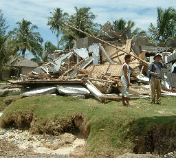
Sorake Beach, Lagundri Bay, Nias Island, Indonesia. House destroyed by March 28 tsunami. Photograph taken by Bob Peters, USGS.
Lagundri, Nias, Indonesia. Schoolhouse severely damaged by March 28, 2005 tsunami. Photograph taken by Widjokongko, Indonesian Tsunami Research Center/Coastal Dynamic Research Center — BPPT.
The 28 March tsunami was large and destructive at Lagundri Bay in SW Nias Island. The team measured tsunami runup of 3 to 4 m and inundation distances of 400 to 500 m. Although there were few building in this location because it is a surf camp, more than 12 buildings were destroyed by the 28 March tsunami. People ran inland and uphill as soon as the earthquake stopped shaking; they were out of harm's way when the tsunami hit. The 28 March 2005 tsunami was larger than the 26 December tsunami at Lagundri Bay in SW Nias Island on 2 April. The 28 March tsunami came ashore as one loud wave. The 26 Dec tsunami did no damage at this location. The 28 March tsunami left a 10 cm thick tsunami deposit. Uplift was small here, less than .3 m. The tsunami arrived 5 to 15 minutes after the earthquake on 28 March. The team is now transiting to the Hinokos Islands offshore of central Nias.
Report from Bob Peters, USGS, via satellite phone at 9:30 pm 1 April 2005 The team went onshore at Simuk Island, which is northwest of the Batu Islands. There was no evidence of either the 26 December or 28 March tsunamis. There was an eyewitness report of 200 m inundation from the 28 March tsunami at a port to the north. Because it was getting dark, they could not go to that location to verify the report. The team is headed to the southern tip of Nias Island and should be there at dawn, when they will go onshore to determine whether or not there was a tsunami from the 28 March earthquake.
Report from Bob Peters, USGS, via satellite phone at
9:30 am 1 April 2005 We motored from Padang to the Batu Islands on 30 March, arriving at southwest Batu Islands the morning of 31 March. The team took the 16' zodiak onshore at Tanahbala to look for evidence of the 28 March 2005 and the 26 Dec 2004 tsunamis. There was no physical evidence for either event. Villagers told the team that the 26 December 2004 tsunami overtopped a 1 m berm and flooded the village. The elevation at the limit of tsunami flooding, which reached 94 m inland, was 0.6 m. The tsunami flooded the floor level of the village houses. There was shaking, but no tsunami, from the 03/28/05 earthquake.
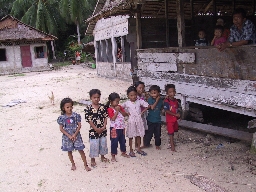
Children at Tanahbala, Batu Islands, Indonesia. 12/26/04 tsunami overtopped 1 m berm. 0.6 m run-up at 94 m inundation. The tsunami reached the floor level of the village houses. There was no tsunami here from the 03/28/05 earthquake. Photograph taken by Bob Peters, USGS.
The team went onshore at a small inner island in the northwest of the Batu Island group. Dead coral blocks were strewn on the ground that were ripped up and brought onshore by the 26 December 2004 tsunami. Again, there was no tsunami from the 28 March earthquake. Locals pointed to where the 26 December 2004 tsunami reached; 2.7 high and only 14 m inland (there is a steep beach at this location). The 26 December tsunami first hit this island at 9:00 am and lasted all day. The biggest waves were from 2:00 to 4:00 in the afternoon. The team is motoring to an outer island to see whether the tsunamis were larger where there is less protection from other islands.
![]()
DISCLAIMER: This material is preliminary and has not been reviewed for conformity with U.S. Geological Survey editorial standards or with the North American Stratigraphic Code. Any use of trade, firm, or product names is for descriptive purposes only and does not imply endorsement by the U.S. Government.
