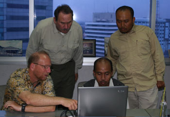
Indonesian Tsunami Research/BPPT, Jakarta, Indonesia 28 April 2005. Members of the ITST look at data collected by the team. From left to right: Dr. Guy Gelfenbaum (USGS), Dr. Bruce Jaffe (USGS), Dr. Gegar Prasetya (BPPT), and Dr. Eko Yulianto (LIPI).
Guy Gelfenbaum, Bob Morton, and I (all USGS) briefed the staff at the US Embassy in Jakarta on 29 April. Anthony Woods, the Economics, Science, Technology, and Health Officer at the Embassy, was keenly aware of tsunami issues in Indonesia. He had just attended a 2-day workshop in Jakarta on a tsunami warning system for Indonesia. We informed Anthony of our results and talked about the need for additional studies that will help mitigate tsunami hazard in Indonesia. We also talked about our observations of the coastal response (continued erosion) to coseismic subsidence in Sumatra during the 26 December earthquake.
Earlier on 29 April we met with scientists from BPPT, including Gegar Prasetya and Director Yusuf Djajadihardja, to discuss a survey of important areas where the team was not able collect data. Together we laid out a plan for a new survey by Indonesian scientists in May to collect data, including information on tsunami deposits, in the areas north and south of Meuluboh.
On Monday we continue working up the data from the survey. I will be posting our report on the preliminary results from the survey on this web site in mid-May. We learned much on the survey that will be of use to Indonesia and elsewhere in the world.
 Report from Bruce Jaffe (USGS) and Gegar Prasetya (BPPT) via internet connection at 11:45 am 29 April 2005 (0445 29 April UTC)
Indonesian Tsunami Research/BPPT, Jakarta, Indonesia 28 April 2005. Indonesian and US scientists and managers discussing tsunami hazard in Indonesia at a meeting where the team presented preliminary results. This meeting was attended by high-level managers and scientists from the agencies responsible for tsunami hazards in Indonesia (BPPT, BMG, GEOTEK LIPI, LIPI Headquarters, ITB, Directorate Volcanology and Geology Hazard Ministry of Mines and Energy). [larger version]
We presented preliminary results from our tsunami field survey at a meeting in at the Indonesian Tsunami Research/BPPT in Jakarta on 28 April. This meeting was attended by high-level managers and scientists from the agencies responsible for tsunamis in Indonesia (BPPT, BMG, GEOTEK LIPI, LIPI Headquarters, ITB, Directorate Volcanology and Geology Hazard Ministry of Mines and Energy). The team reported on measurements along more than 800 kilometers of coast, from Batu Islands in the south to Weh Island in the north. We reported findings about tsunami water levels, flow depths, flow directions, run-up elevations, inundation distances, tsunami deposit thickness and character, magnitude of subsidence and uplift, underwater topography, and eyewitness reports. We collected detailed bathymetric data at 5 locations for use in inundation and tsunami sediment transport modeling. The tsunami deposit data set is fantastic—9 detailed sediment transects and hundreds of samples for laboratory analysis. We discovered possible paleotsunami deposits at 3 sites. These sites are good candidates for future studies of paleotsunami deposits to extend the record of tsunamis in Indonesia.
One of the questions going into the survey was whether there was a tsunami generated by the 28 March earthquake. There was a 28 March 2005 tsunami. Fortunately, there was no loss of life from this tsunami, in part because people were hyper-aware of the danger of a tsunami because of the 26 December tsunami and fled the coast as soon as the shaking stopped. The 28 March tsunami was small compared to the 26 December tsunami in all but two locations; however, it was not a small tsunami. The team found evidence of the 28 March tsunami along 500 kilometers of coast. Maximum run-up elevations were approximately 4 meters, and flow depths were greater than 3 meters. Tsunami flow depths deeper than one-half meter can be fatal. It was powerful enough to destroy buildings and capable of causing fatalities.
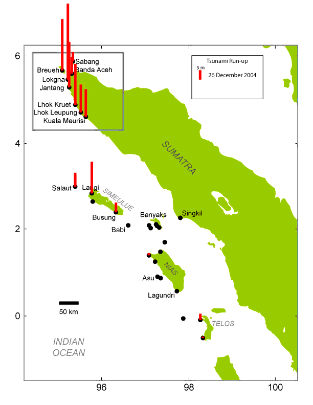 This map depicts run-up elevations from the 26 December 2004 tsunami, which were measured by the ITST during this field survey. The team took measurements of the 26 December tsunami along 800 kilometers of coast. [larger version] |
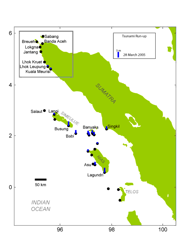 This map depicts run-up elevations from the 28 March 2005 tsunami, which were measured by the team during this field survey. There was a tsunami generated by the 28 March 2005 earthquake. The team collected data on this tsunami along 500 kilometers of coast. [larger version] |
The team added to the data set for the 26 December tsunami. One of our major contributions is collection of integrated data sets that include a high density of tsunami flow, tsunami deposit, topographic, and bathymetric information. We also were able to collect less dense data in locations where other International Tsunami Survey Teams had not visited.
Guy Gelfenbaum, Bob Morton, and Bruce Jaffe (all USGS) are giving a briefing at the US Embassy in Jakarta later today.
Report from Bruce Jaffe (USGS), via satellite phone at 10:45 pm 25 April 2005 On 22 April the team continued to take measurements of the 26 December 2004 and 28 March 2005 tsunami in Langi Bay. The 26 December tsunami was large here. Run-up heights were more than 10 m above the present sea level. The 26 December tsunami destroyed many buildings in the village. Because of stories passed down from generation to generation, the people in the village fled to the hills as soon as earthquake stopped shaking. There were no casualties—everyone made it to safety before the tsunami hit. The last large tsunami to hit this village was 1907. The 28 March tsunami was small here, less than 1 m above sea level.
On 23 April the team went to Gusong Bay, a location that the leg 1 team had visited. The 26 December tsunami was slightly larger than the 28 March tsunami—both had run-up heights greater than 4 meters. Both tsunamis left sand deposits. The boundary between the two tsunami deposits was marked a layer of grass that had grown between 26 December 2004 and 28 March 2005. The tsunami deposits found by the team will be analyzed to learn more about the speed and size of the 28 March and 26 December tsunamis in Gusong Bay.
On 24 April the team started the transit back to Padang. We are organizing sediment samples (several hundred taken on leg 2) and analyzing the data we collected as we motor back to the home base for the Seimoa for the season. We are also preparing for presentations to Indonesian science agencies, managers, and press in Jakarta later this week. We will arrive in Padang the morning of 26 April.
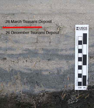
Gusong Bay, SW Simeulue Island, Indonesia 23 April 2005. Sand left behind by the 28 March 2005 and 26 December 2004 tsunamis. The 28 March tsunami deposit overlies the 26 December tsunami deposit. The boundary between the two deposits is marked by grass that grew on the 26 December tsunami deposit before the 28 March tsunami hit. The tsunami deposits will be analyzed to learn more about the speed and size of the 28 March and 26 December tsunamis in Gusong Bay. Photo taken by Bruce Jaffe, USGS.
Report from Bruce Jaffe (USGS), via satellite phone at 10:45 pm 21 April 2005 The team finished the sediment transect at Kuala Mersi on 20 April. We set a new record for the longest sediment transect for a modern tsunami—about 1700 m.
Rebuilding has started in the Calang area. It is an inspiration to watch the Indonesians clear up the debris from the 26 December tsunami and build their new homes. They face difficult decisions on where and how to build.
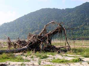
We steamed to Simeulue Island last night. This morning, we scouted for the best locations to study tsunami deposits. We decided to stop at Langi Bay. An International Tsunami Survey Team (primarily Russian and Indonesian tsunami scientists) visited this location in January, and measured 15 m tsunami flow depths from the 26 December tsunami. While we were working today, it rained so hard that it felt like I was taking a shower. Fortunately, this only lasted for about an hour.
The deposits in Langi Bay are stunning—alternating layers of sand and mud. They remind me of ones I've seen in the Pacific Northwest. The team will spend another day studying the deposits here. This information will help determine the size of past tsunamis in the Pacific Northwest and elsewhere in the world.

Calang, Sumatra, Indonesia 20 April 2005. Rebuilding after the 26 December tsunami. In the foreground are foundations of houses destroyed by the tsunami.
Report from Bruce Jaffe (USGS), via satellite phone at 7:15 am 20 April 2005 
Kuala Mersi, Sumatra, Indonesia 19 April 2005. Widjokongko (Indonesian Tsunami Research Center/Coastal Dynamic Research Center - BPPT) and Bretwood Higman (University of Washington) examining tsunami sand deposits at approximately 1200 m from the ocean. The 26 December tsunami deposited sand and mud more than 1500 m from the ocean at Kuala Mersi. Tsunami deposits cover the entire area of the photograph. The pattern on the ground is from a mud cap to the tsunami sand deposit drying and breaking apart (mud cracks). The pile of trees in the background were transported inland by the 26 December tsunami. Photograph taken by Bruce Jaffe, USGS.
The 26 December tsunami brought sand and mud more than 1500 m from the ocean at Kuala Mersi. The team divided into two groups to cover more ground because most of the 1500 m transect was covered by tsunami deposits. Tsunami flow depths were still large at this site, greater than 8 m, but less than flow depths at sites to the north visited by the team. The 26 December tsunami destroyed all the houses in Kuala Mersi. Today the heat was intense, as usual, about 90 degrees and very humid. The team is only able to work 6 to 8 hours before the heat drains them. The team that surveyed the inland portion of the transect experienced a nice diversion from their work—beautiful, colorful dragonflies flew about and landed on them and the tsunami deposits. Because the transect is so long, the team will return to the same site today to complete its work.
Report from Bruce Jaffe (USGS), via satellite phone at 6:30 am 19 April 2005 18 April 2005
The team took measurements at Lhok Leum Pang, approximately 10 km north of Ailu Titi, on 18 April. The 26 December tsunami height continues to decrease towards the south, but the decrease is not rapid. Tsunami run-up heights are 12 m and inundation distances are more than 2 kilometers in low-lying areas. Eyewitnesses report that the 28 March tsunami was approximately 1 m here. The team set a record for the longest sediment transect for a modern tsunami—about 850 m. The Indonesian military has offered to take the team by truck to the south to do its work. The roads in this section of Sumatra are rebuilt. Today, the team will continue collecting measurements of tsunami water levels and sediment in the region to the south of Calang.
Lhok Leum Pang, Sumatra, Indonesia 18 April 2005. The morning commute. The team can only get to shore by dingy in many locations. On this day, the waves were large and we had to time our landing to come ashore between sets of large waves. From left to right: Bretwood Higman (University of Washington), Darren Stockwell (Seimoa 1st Mate), Eko Yulianto (The Indonesian Institute of Science), and Andy Moore (Kent State University).
17 April 2005
The team took measurements at Lhok Kruet on 17 April. This is a location that the Leg 1 team also went to. The 26 December tsunami was slightly smaller here than at Jantang. Run-up heights were 17 to 18 m, and inundation distances exceeded 2 kilometers. Tsunami flooding reached the base of the cliff in many locations. Palm trees in the water indicated that there was subsidence from the 26 December earthquake at this location. Tsunami sand deposits were extensive here. The team will transit to Lhok Kruet tonight and go ashore in the morning.
Lhok Kruet, Sumatra, Indonesia, 17 April 2005. Lori Dengler, Humboldt State University, in front of a large tree that survived the 26 December tsunami. Note the branches broken by the 26 December tsunami. Debris high in the tree indicate that the tsunami was greater than 10 m at this location, which is approximately 300 m inland. Photograph taken by Bruce Jaffe, USGS.
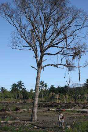
Report from Bruce Jaffe (USGS), via satellite phone at 11:55 pm 17 April 2005 The 26 December tsunami had run-up heights of 19 m and flow depths greater than 13 m at Jantang, a village in the Gleeburk region. The 26 December tsunami destroyed nearly all the buildings in Jantang. The team saw countless building foundations with no buildings on them. Most trees were ripped out of the ground or snapped by the force of the tsunami. A 10-m-high tsunami will move faster than 20 miles per hour. Tsunami sand deposits were extensive here. The team will transit to Lhok Kruet tonight and go ashore in the morning.
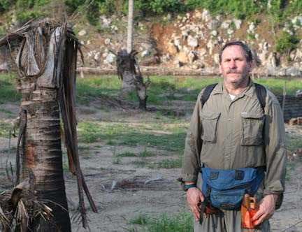
Jantang, Sumatra, Indonesia, 17 April 2005. Bruce Jaffe, USGS, next to a palm tree snapped off by the 26 December tsunami. Note that all the vegetation on the cliff in the background was stripped by the tsunami to a height of approximately 15 m. Photograph taken by Bretwood Higman, University of Washington.
Report from Bruce Jaffe (USGS), via satellite phone at 10:45 pm 15 April 2005 The team was delayed to allow the generators on the Seimoa to be repaired, and we did not leave Weh Island until just after noon on 15 April. We motored to the west coast of Breuh Island. Breuh Island is northwest of Banda Aceh. The 26 December tsunami was large here and removed all trees up to 22 m above sea level on the cliffs. Inundation distance, which was low because the tsunami was stopped by a cliff, was greater than 650 m at this location. The tsunami was moving fast when it hit the cliff; a metal telephone pole 20 m above sea level and near the limit of inundation was bent over by the tsunami. The tsunami moved large amounts of sediment at this location. Tsunami sand deposits were discontinuous here but thick (up to 29 cm) at some locations. The 26 December tsunami filled a large river channel with sand, causing it to change its course. Large coral boulders were transported hundreds of meters inland. The team will transit to Gleeburk tonight and go ashore in the morning to take additional measurements of tsunami water levels and sediment deposits.
Breuh Island, Indonesia, 15 April 2005. Peter Ruggiero, USGS, in front of a tree ripped up by the 26 December tsunami. Tsunami flow depth at this location, more than 300 m inland, was greater than 7 m. Run-up was approximately 22 m, and inundation distance, which was low because the tsunami hit a cliff, was greater than 650 m. Photograph taken by Bruce Jaffe, USGS.
Report from Bruce Jaffe (USGS), via Internet Café at 6:45 pm 13 April 2005 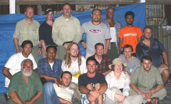
Changing of the Guard, Sabang, Weh Island, Sumatra, 12 April. Members of Leg 1 and Leg 2 met to exchange data and stories. Photograph taken by Bruce Jaffe, USGS.
The Leg 2 team flew from Jakarta to Banda Aceh yesterday and took a ferry to Weh Island. The ferry dock was in the 26 December tsunami zone of destruction. Life is returning to the Banda Aceh region, even in the tsunami destruction zone. Rebuilding is starting. We met with the Leg 1 team to exchange data and stories. The Seimoa leaves Sabang at midnight to revisit Gleeburk to study sand brought onshore by the 26 December tsunami. The sand, which remains long after the tsunami is gone, leaves clues about the tsunami's size and power. The Leg 2 team will study the sand to learn how to read the clues tsunami sand contains.
![]()
DISCLAIMER: This material is preliminary and has not been reviewed for conformity with U.S. Geological Survey editorial standards or with the North American Stratigraphic Code. Any use of trade, firm, or product names is for descriptive purposes only and does not imply endorsement by the U.S. Government.
