
Preliminary Analysis of Sedimentary Deposits
from the June 23, 2001 Peru Tsunami
A Cooperative Study by the United States Geological Survey,
la Dirección de Hidrografía y Navegación de la Marina de Guerra del Perú,
Instituto Geofísico del Perú,
Instituto Geologico, Minero y Metalurgico,
University of California, Santa Cruz,
University of Southern California
and University of San Agustin.
September 4 - September 18, 2001
Introduction
[ Introduction | Team | Importance of Studying Tsunami Sediments | Survey and Methods | Damage | Run-up | Sedimentary Deposits | Preliminary Results | Future Research | Acknowledgments ]
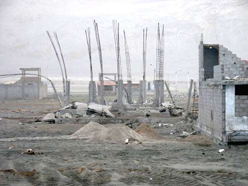
On June 23, 2001 a deadly tsunami hit the southern coast of Peru, triggered by a massive earthquake of moment magnitude 8.4, the largest earthquake recorded worldwide in 35 years. The tsunami was observed in many coastal areas of the Pacific including Peru, Chilé, Hawaii, and Japan. Hardest hit was the region around Camaná, Peru, where more than 20 people died as a result of the tsunami and thousands of homes, hotels, and restaurants were destroyed. Shortly after the tsunami, a multi-national team of scientists visited Peru to document the effects of the tsunami. This group is referred to as the first International Tsunami Survey Team (1st ITST). In early September, a second group of scientists from the United States and Peru cooperated in a study of sediment deposited by the tsunami. The group included researchers from the United States Geological Survey USGS), la Dirección de Hidrografía y Navegación de la Marina de Guerra del Perú (DHN), Instituto Geofísico del Perú (IGP), Instituto Geologico, Minero y Metalurgico (INGEMMET), University of California, Santa Cruz (UCSC), University of Southern California (USC) and University of San Agustin (UNSA). This report contains photographs from the September trip, as well as some prelimary results and conclusions.
Preliminary modeling of the tsunami was done by Eric Geist of the U.S. Geological Survey. The modeling results predict that the largest run-ups are centered around Camaná, even though the epicenter for the earthquake was approximately 100 km to the NW. This was because the largest slip values, which are directly linked to the initial tsunami amplitude, were centered beneath Camaná. Model results, including tsunami animations, are available.
The U.S. National Oceanic and Atmospheric Administration (NOAA/PMEL) has assembled a compilation of web links to data on the June 23, 2001 Peru tsunami. This site has links to field survey data, sea level data, seismic data, and model simulations. Previous tsunami sediment surveys include a survey of sediments deposited by the 1998 Papua/New Guinea Tsunami.