Link to USGS home page Link to USGS Home PageGo to the Pacific Coastal and Marine Science Center Home Page

Preliminary Analysis of Sedimentary Deposits
from the June 23, 2001 Peru Tsunami


[ Introduction | Team | Importance of Studying Tsunami Sediments | Survey and Methods | Damage | Run-up | Sedimentary Deposits | Preliminary Results | Future Research | Acknowledgments ]


Results

  • Sediment deposits were found at all sites.
  • Sediment deposit thickness is variable, effected by distance from the shoreline, local topography, and change in slope.
  • Only a few sites had easily identifiable deposits.
  • Some deposits were normally graded, some were inversely graded, and some had no visible grading.
  • Flow indicators suggest significant onshore flow and weaker, but significant offshore flow.

Plot showing deposit at Amecosupe thins landward and with increasing elevation.

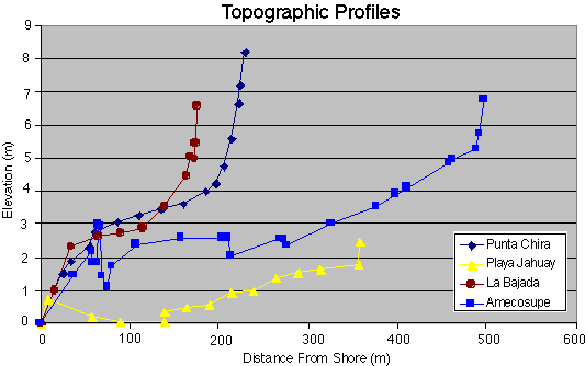
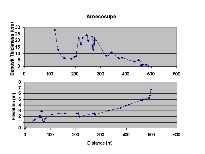
The deposits from the tsunami exhibited a wide variety of forms throughout the study area. Thickness varied both with distance inland and with site. The thickest deposits measured were at Amecosupe. While sedimentary structures were usually absent, many deposits contained 2-4 internal layers. Each layer is believed to represent deposition from a single wave within the tsunami wave train. Eye-witness accounts report that the tsunami consisted of 3-4 waves, with the second and third waves being the largest. The greatest run-up measured (from mid-swash, uncorrected for tides) was 8.2 meters at Playa la Chira. The greatest inundation distance measured (from mid-swash, uncorrected for tides) was 760 meters at La Quinta. The 1st ITST measured inundation distances of up to 1 km at some locations.

Topographic profiles for four sites surveyed.
Topographic profiles from four sites surveyed by the team.

tsunami/peru2/results.html
content by Bruce Jaffe and Guy Gelfenbaum
last modified 2002