|
|
Instrument Deployments
During the USGS study, instrumented tripods were deployed and recovered at LT-A three times each year, typically in February, May or June, and September. This report presents photographs obtained during 19 deployments that took place during the period October 1996 through September 2005. The deployments are identified by a three-digit USGS mooring number that is assigned sequentially to all instrument deployments (table 2). The camera on tripods 632 and 708 failed to operate. Because of camera and strobe failures, systems were not available to be deployed on tripods 611, 645, 683, 697, and 756 (table 1).
Each tripod was located near the USCG Boston Approach B Buoy (National Ocean Service, 1997) on the southern flank of a ridge in water about 32 m deep (fig. 8). This location was selected for long-term observations because the USCG buoy marked the site and provided some physical protection from other marine activities.
Table 2. USGS mooring number, date, location, and water depth of time-series photographs contained in this Data Series report.
| Mooring number | Start/Stop date | Latitude (N) | Longitude (W) | Water depth (m) |
|
480 | October 1, 1996
February 9, 1997 | 42 22.74 | 70 46.84 | 31 | |
495 | February 17, 1997
June 10, 1997 | 42 22.63 | 70 47.07 | 31 | |
501 | June 10, 1997
September 23, 1997 | 42 22.63 | 70 47.07 | 31 | |
507 | September 23, 1997
November 12, 1997 | 42 22.64 | 70 47.07 | 31 | |
516 | February 10, 1998
June 10, 1998 | 42 22.62 | 70 47.08 | 31 | |
530 | June 17, 1998
September 30, 1998 | 42 22.62 | 70 47.08 | 31 | |
540 | September 30, 1999
February 8, 1999 | 42 22.64 | 70 47.09 | 31 | |
552 | February 10, 1999
May 7, 1999 | 42 22.64 | 70 47.07 | 31 | |
569 | May 11, 1999
September 15, 1999 | 42 22.68 | 70 47.09 | 33 | |
591 | September 26, 1999
December 10, 1999 | 42 22.68 | 70 47.09 | 31 | |
625 | May 13, 2000
September 11, 2000 | 42 22.69 | 70 47.09 | 30 | |
638 | February 14, 2001
May 24, 2001 | 42 22.68 | 70 47.09 | 31 | |
665 | October 23, 2001
February 6, 2002 | 42 22.68 | 70 47.09 | 30 | |
690 | May 21, 2002
September 23, 2002 | 42 22.67 | 70 47.10 | 31 | |
717 | September 24, 2003
February 1, 2004 | 42 22.68 | 70 46.09 | 31 | |
767 | May 19, 2004
July 17, 2004 | 42 22.68 | 70 46.09 | 31 | |
775 | September 22, 2004
January 27, 2005 | 42 22.72 | 70 46.84 | 31 | |
777 | February 9, 2005
May 14, 2005 | 42 22.72 | 70 46.85 | 32 | |
786 | May 18, 2005
July 15, 2005 | 42 22.72 | 70 46.85 | 33 |
|
Click on thumbnail below for figure in PDF format.
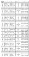 Table 1.
Chronological list of moorings deployed at LT-A in western Massachusetts Bay between 1989 and 2006, and citation for publications. (HTML format; PDF format)
 Figure 8.
Location of tripod moorings (over-lapping red triangles) at LT-A in western Massachusetts Bay deployed from 1989-2005.
|