|
|
|
| Coastal and Marine Geology Program | |
| Woods Hole Science Center | |
![]() U.S.
Geological Survey Open-File Report 2005-1018
U.S.
Geological Survey Open-File Report 2005-1018
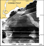
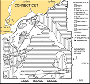
Surficial Geologic Interpretation and Sidescan Sonar Imagery of the Sea Floor in
West-Central Long Island Sound
SIDESCAN-SONAR IMAGERY
The distribution of surficial sediment and sedimentary environments within the study area were determined using tonal changes in backscatter of the sidescan-sonar mosaic, bathymetry, and ground-truth data (DiGiacomo-Cohen and others 1998; Poppe and others 1998c, Poppe and others 2000b). Areas of high backscatter typically indicate coarser grained sediment, which suggests higher energy environments, while low backscatter suggests finer grained sediment, which reflects lower energy environments. A speckled high-backscatter pattern indicates rocky areas. Some abrupt tonal changes within the mosaic may be artifacts of the mosaicking process. In addition to sediment distribution, the mosaic shows anthropogenic influences on the sea floor: shipwrecks, pipelines and/or cables, a breakwater, trawl marks from commercial fishing, lobster pots, and some nearby ship wakes, which create an acoustic artifact in the water column. Geologic Features
Large areas of low backscatter occupy the central and far northeastern parts of the study area where the sea floor is smooth and protected from tidal- and storm-current regimes. As well, there are smaller regions of low backscatter spread throughout the study area. The largest areas of high backscatter are found on the tops of shoals and along the elongate bathymetric high in the northeastern part of the study area. Other regions of high backscatter occur on isolated bathymetric highs in the southeastern parts of the study area. Speckled patches of higher backscatter targets indicate rocky areas on the top of Stratford Shoal and in isolated patches near the Connecticut shoreline.
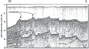
The northwestern corner of the study area is characterized by sand waves appearing as areas of tiger-stripe backscatter (Wynn and others 2002). The sinuous crests of the waves are oriented north-south, transverse to the predominant current directions. They are spaced roughly 100-300 m apart with those in the south having wider spacing than those in the north, where the sand waves bifurcate. A seismic line across the sand-wave area shows the waves asymmetrical profiles. The six sand waves in this profile, which range from 1.5 m to 3.5 m high, have average stoss slopes of 1.5º and lee slopes of 3.7º. Lee sides of the sand waves on the western side are oriented to the west. Lee sides of the sand waves on the eastern side are oriented to the east.
The sidescan-sonar mosaic contains some areas of moderate backscatter having elongate sinuous features of weak backscatter. These features are about 500 m long, average less than 10 m in width, and occur in depths from 9-13 m. They extend roughly perpendicular to the bathymetric contours, and most bifurcate upslope with tuning fork-like intersections. The seismic data show a smooth sea floor in the area, indicating these features have little, if any, relief. They appear to be formed by density currents of fine-grained sediments moving down-slope and, as such, may represent pathways through which sediments are remobilized and transported into the deeper basins. Whether these features are a result of local micro-bathymetry or also related to fluvial outflow from the Housatonic River is unknown.
|
 |
|
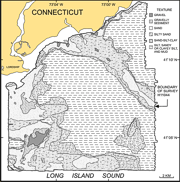
Map showing the surficial sediment distribution within NOAA survey H11044. |
Sidescan-sonar imagery and bathymetry combined with sediment data from 487 stations were used to determine the distribution of surficial sediments within the study area. The area is dominated by poorly and very poorly sorted silt and sandy or clayey silt in the central parts. These muddy sediments are also located in the far northeastern corner, as well as in a fan-shaped deposit to the west of Stratford Shoal and at the widening eastern end of the axial depression. Silty sand is located on the bathymetric ridge in the northeast, on the flanks of the shoals, in the axial trough and into the southern basin. Sand-silt-clay is mostly located to the east of both shoals, on the bathymetric highs in the southeast, and along the flanks of the bathymetric ridge. Areas dominated by silty sand and sand-silt-clay mark transitions between fine- and coarse-grained sediments and relatively low- and high-energy environments.
Gravel and very poorly sorted gravelly sediments are found on the tops of Stratford Shoal, the shoal south of Lordship, Connecticut, and in patches on the bathymetric ridge in the northeastern part of the study area. Gravelly patches are also located near the Connecticut coastline and the center of the axial trough. Sand surrounds the gravelly areas on the top and flanks of the shoals, bathymetric ridge and isolated bathymetric highs in the southeast. Sediments that are dominantly sand also extend along the Connecticut shoreline and appear in restricted areas of the southern basin as well. These sediments are mostly poorly and very poorly sorted medium- to fine-grained sand. They are most likely sourced from glaciolacustrine deltaic deposits described earlier (Lewis and DiGiacomo-Cohen 2000). The patches of coarse sediment along the Connecticut shoreline are often associated with small local bathymetric highs that tend to parallel the north-south ridges evident in the onshore topography (Flint 1965, Flint 1968; Rodgers 1985). This sediment distribution is similar to that reported by Poppe and others (2000a) for the region, but is presented here in greater detail.
 |
|
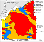
Map showing the sedimentary environment distribution within NOAA survey H11044. |
Four different sedimentary environments are present in the study area: fine-grained deposition, sediment sorting and reworking, coarse-grained bedload transport, and erosion or nondeposition. These environments are determined by tonal changes in the sidescan-sonar mosaic, sediment distribution, and bathymetry.
 |
|
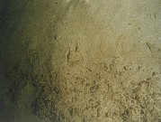
Bottom photograph showing an example of a sedimentary environment characterized by deposition. |
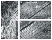
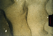
Muddy sediments and low backscatter on sidescan-sonar images distinguish areas of fine-grained deposition. These low-energy environments are located throughout much of the central and far northeastern parts of the study area and in localized areas around Stratford Shoal. A fan shaped deposit is located to the west of Stratford Shoal. Bottom currents flow westward down the flanks of the shoal (Signell and others 2000), but this area is most likely in a shadow of these currents, allowing for deposition to occur. Deposition is also occurring near the entrance to the axial trough between the two western shoals where current speeds decrease as they become less constricted. Signell and others (2000) found that depositional environments in LIS have average current speeds of less than 15-25 cm/s, which reflects the protected areas in which we find fine-grained deposition. Central parts of the study area are relatively deep and smooth, making them less susceptible to wave- and wind-induced currents than bathymetric highs. Thus, these low-energy environments also allow for fine-grained deposition.
 |
|
Bottom photograph showing an example of a sedimentary environment characterized by sorting or reworking. |
Fine sands that coincide with moderate backscatter on the sidescan-sonar imagery characterize areas of sediment sorting and reworking. These environments are located on the flanks of the shoals, in the southern basin, on the bathymetric highs in the southeast, along the northern shore and on the bathymetric ridge in the northeast. Areas of sediment sorting and reworking are primarily located between erosional and depositional environments (Knebel and Poppe 2000). This transitional location suggests that bottom currents, averaging less than 25 cm/s in this environment, have a restricted ability to sort and winnow coarser grained sediments (Poppe and others 2000a; Signell and others 2000), but can remobilize fine-grained material. Bands of low backscatter appear on the sidescan-sonar mosaic in some regions of this environment, which we speculate may be formed by density currents of fine-grained sediments moving down-slope. If this is true, they may represent pathways through which sediments are remobilized and transported into the deeper basins.
 |
|
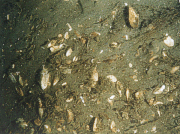
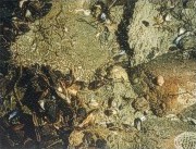
Bottom photograph showing an example of a sedimentary environment characterized by coarse bedload transport. |
Environments of coarse-grained bedload transport are characterized by sand and gravelly sand and the presence of sand waves (Knebel and Poppe 2000). Two areas of coarse-grained bedload transport are located in the study area. The largest is on the unnamed shoal south of Lordship and a small area (0.2 km2) is present on Stratford Shoal. Sand waves on the unnamed shoal bifurcate towards the north, which may imply transitional dynamic conditions (Aliotta and Perillo 1987). Current speeds in environments of coarse-grained bedload transport average about 35-45 cm/s (Signell and others 2000). The lee slope orientations of the sand waves located to the east of the unnamed shoal suggest they were formed by diverging currents. Signell and others (2000) proposed that currents in this area diverge and they converge on the top of the shoal. The converging currents that result in the accumulation of sediment, which probably balances the erosion on the flanks of the shoal in strong storms and helps to keep it maintained (Signell and others 2000). Twichell and others (1998) interpreted these sediment waves as relict bedforms that are not actively moving due to the absence of smaller bedforms associated with them. However, it appears that the present current regime is, at least, preserving the sand waves.
 |
|
Bottom photograph showing an example of a sedimentary environment characterized by erosion or nondeposition. |
High and speckled backscatter areas generally coincide with coarse-grained sediments in the study area, which together indicate areas of erosion or nondeposition. These areas are located along the northern crest of the bathymetric ridge in the northeast, in isolated areas near the Connecticut shoreline, on Stratford Shoal, to the east of the shoal south of Lordship, on the bathymetric highs in the southeast, and in the center of the axial trough. Surface waves remove fine-grained sediments in shallow environments (Signell and others 2000), leaving the coarse sediments found along the shallow margins. Bottom currents produced by tides, wind, and waves (Knebel and Poppe 2000) prevent deposition on the bathymetric highs, such as Stratford Shoal, and contribute to erosion and nondeposition in constricted areas, such as the center of the axial trough between the two shoals (Signell and others 2000).
The surficial geology of the sea floor in west-central Long Island Sound interpreted from sidescan-sonar data, sediment samples, bathymetric, and seismic data show that over much of the central part of the area and in the more protected far northeastern corner the low energy on the deeper sea floor results in a depositional sedimentary environment having a bottom surface of silt and sandy or clayey silt. Areas of sediment sorting and reworking surround most of the sedimentary environments characterized by deposition. These processes reflect the transition between low- and high-energy sedimentary environments and are located where silty sand grades into sand-silt-clay. Within the sorting and reworking environments are some areas that appear to have down-slope density-flow pathways. Sand waves on the shoal in the northwestern corner of the study area indicate an environment of coarse-grained bedload transport. Isolated bathymetric highs, such as those in the southeast, the bathymetric ridge in the northeast and Stratford Shoal tend to have high-energy sedimentary environments of erosion or nondeposition with surfaces of gravel, gravelly sediment, and coarse sand. Small patches of erosion occur along the northern boundaries of the study area as well.
![]()