|
|
|
| Coastal and Marine Geology Program | |
| Woods Hole Science Center | |
![]() U.S.
Geological Survey Open-File Report 2005-1018
U.S.
Geological Survey Open-File Report 2005-1018
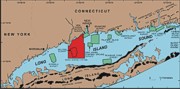
Surficial Geologic Interpretation and Sidescan Sonar Imagery of the Sea Floor in
West-Central Long Island Sound
INTRODUCTION
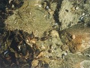
The United States Geological Survey (USGS) is working cooperatively with the National Oceanic and Atmospheric Administration (NOAA) and Connecticut Department of Environmental Protection (CT-DEP) to conduct detailed studies of the surficial geology in Long Island Sound (LIS). The study goals are to interpret sedimentary environments within the Sound, to further understand processes controlling sediment distribution, and to provide a framework for future studies. Sidescan-sonar mosaics produced by USGS and NOAA show detailed acoustic images of the sea floor with 1-m resolution. These images, along with data obtained from sediment samples, seismic-reflection profiles, and seafloor video, are used to interpret the surficial geology.
As part of this cooperative program, since 1995, 12 sidescan-sonar surveys of the LIS sea floor have been completed (Poppe and others, 1997; Twichell and others, 1997; Poppe and others, 1998a; Poppe and others, 1998b; Twichell and others, 1998; Poppe and others, 1999a; Poppe and others, 1999b; Poppe and others, 2001; Poppe and others, 2004; Zajac and others, 2003). The purpose of this report is to release digital versions of the imagery and interpretations from NOAA survey H11044 originally published in McMullen and others (2005). Survey H11044, which covers an area of 293 km2 in west-central LIS, includes the area of the previously published Milford Survey (Twichell and others, 1998) and the westernmost part of the New Haven Harbor Survey (Poppe and others, 2001). These two surveys detailed surficial geology and mapped sediment distributions. In this study, we map the sediment distribution across a broader, previously unstudied area and the sedimentary environments. |
![]()