USGS Coastal and Marine Hazards and Resources Program
Historical Shoreline Changes at Rincón, Puerto Rico, 1936-2006
|
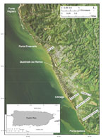
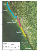
Coastal erosion is a widespread and ongoing process in Puerto Rico (Bush and others, 1995). As discussed by Thieler and others (1995), coastal erosion in Rincón is well documented. A previous assessment of shoreline change in Rincón (fig. 1) by Thieler and others (1995) computed long-term (44 years from 1950-1994) erosion rates and identified four distinct coastal reaches between Punta Higüero and Punta Cadena (fig. 2). Reach A, from Punta Higüero to just south of Punta Ensenada, was characterized as a relatively stable to slowly eroding coast comprised of a thin sandy beach overlying various indurated (rocky) substrates. Reach B, from south of Punta Ensenada to south of Quebrada los Ramos, was characterized as a rapidly eroding sandy coast backed by unconsolidated alluvial deposits. There appeared to be a change in trend toward increasing erosion in Reach B between 1977 and 1987. Reach C, from south of Quebrada los Ramos to Córcega, was characterized as a slowly eroding sandy coast backed by unconsolidated alluvial deposits. Reach D, from Córcega to Punta Cadena, was characterized as a stable to slowly eroding sandy coast backed primarily by unconsolidated alluvial deposits. Beaches within the study area are composed primarily of biogenic shelf carbonates and river-derived terrigenous material (Morelock, 1987). The primary sources of new sediment to the beach system are biological production and bioerosion of nearshore reefs, as well as erosion of both modern and relict alluvial deposits along the coast. The direction of net alongshore drift is to the south (Morelock, 1987).
Morelock (1987) describes the west coast of Puerto Rico as compartmentalized, with little to no sediment exchange between adjacent littoral cells. The insular shelf between Punta Higüero and Punta Cadena (the Rincón - Córcega littoral cell) is generally less than a few hundred meters wide. This situation further limits sediment transport between littoral cells; some sand is probably lost off the shelf into deeper water. This report documents shoreline changes that have occurred since the 1994 field survey and shoreline change-rate estimates reported by Thieler and others (1995), and constitutes a substantial expansion and revision of the previous work. The shoreline-change data and analysis presented in this report is expanded to include additional historical shorelines, as well as new GPS-based shoreline positions obtained in December 2005 and December 2006. The new shoreline data, as well as new ancillary data for the area, allow for a more refined picture of shoreline change trends and the potential underlying causes. |
Click on figures for larger images.
|