
Click on figure for larger image. 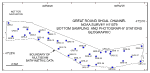 | Figure 15. Map showing the station locations used to verify the acoustic data with bottom sampling and photography during the RAFAEL 06005 cruise.
|
The sediment grain-size dataset provided here contains information on the collection, location, description, and texture of sediments at stations occupied during the verification cruise RAFAEL 06005 (fig. 15). All analyses were conducted in the sedimentation laboratory at the USGS's Woods Hole Science Center. Records without textural data and statistics are based on visual descriptions. The basic structure of the data is in "flat-file" format, a matrix where records are rows representing individual samples and the columns contain sample- and station-specific information. This matrix contains 43 fields which are defined in the Data Dictionary below.
The sediment data are provided in two formats: Microsoft Excel and delimited ASCII text format. In the delimited ASCII text file, each field or column of data is separated from the next by commas and can be downloaded into many types of software.
raf06005_seddata.xls
raf06005_seddata.txt
Data Dictionary
An integral part of any database is the dictionary that explains the structure and content. It contains a list of the fields and the definitions of parameters measured. Data utilization is facilitated by reference to this compilation because it defines abbreviations and lists field names.
LABNO - Unique sample identifier assigned in the laboratory
STATIONID - Sample name or number as assigned in the field
PROJECTID - Project under which samples were taken or data generated
CRUISEID - Name or number of cruise on which sample collected or station occupied
PRINCIPAL - Name of Principal Investigator
MONTH - Calendar month sample analyzed
DAY - Calendar day sample analyzed
YEAR - Calendar year sample analyzed
LATITUDE - Latitude in decimal degrees
LONGITUDE - Longitude in decimal degrees (west longitudes are negative values)
DEVICE - Device used to collect the sample
AREA - General geographic area
DEPTH_M - Measured depth of water overlying sediment at sample time, not corrected for tides, in meters
T_DEPTH - Top depth of the sample below the sediment-water interface, in cm
B_DEPTH - Bottom depth of the sample below the sediment-water interface, in cm
WEIGHT - Weight of sample in grams
ZGRAVEL - Gravel content in percent dry weight of the sample (particles with nominal diameters greater than 2 mm; -1 phi and larger)
ZSAND - Sand content in percent dry weight of the sample (particles with nominal diameters less than 2 mm, but greater than or equal to 0.0625 mm ; 0 through 4 phi)
ZSILT - Silt content in percent dry weight of the sample (particles with nominal diameters less than 0.0625 mm, but greater than or equal to 0.004 mm; 5 through 8 phi, inclusive)
ZCLAY - Clay content in percent dry weight of the sample (particles with nominal diameters less than 0.004 mm; 9 phi and smaller)
SEDCLASS - Sediment description based on a rigorous definition (Shepard, 1954)
MEDIAN - Middle point in the grain size distribution in phi units
MEAN - Average value in the grain size distribution in phi units
STDDEV - Standard deviation (root mean square of the deviations) of the grain size distribution in phi units (i.e., sorting)
SKEWNESS - Deviation from symmetrical form of the grain size distribution in phi units
KURTOSIS - Degree of curvature near the mode of the grain size distribution in phi units
PHI_11 - Weight percent of the sample in the 11 fraction (nominal diameter of particles greater than or equal to 0.5 µm, but less than 0.001 mm); fine clay
PHI_10 - Weight percent of the sample in the 10 fraction (nominal diameter of particles greater than or equal to 0.001 mm, but less than 0.002 mm); medium clay
PHI_9 - Weight percent of the sample in the 9 fraction (nominal diameter of particles greater than or equal to 0.002 mm, but less than 0.004 mm); coarse clay
PHI_8 - Weight percent of the sample in the 8 fraction (nominal diameter of particles greater than or equal to 0.004 mm, but less than 0.008 mm); very fine silt
PHI_7 - Weight percent of the sample in the 7 fraction (nominal diameter of particles greater than or equal to 0.008 mm, but less than 0.016 mm); fine silt
PHI_6 - Weight percent of the sample in the 6 fraction (nominal diameter of particles greater than or equal to 0.016 mm, but less than 0.031 mm); medium silt
PHI_5 - Weight percent of the sample in the 5 fraction (nominal diameter of particles greater than or equal to 0.031 mm, but less than 0.0625 mm); coarse silt
PHI_4 - Weight percent of the sample in the 4 fraction (nominal diameters of particles greater than or equal to .0625 mm, but less than 0.125 mm); very fine sand
PHI_3 - Weight percent of the sample in the 3 fraction (nominal diameter of particles greater than or equal to 0.125 mm, but less than 0.25 mm); fine sand
PHI_2 - Weight percent of the sample in the 2 fraction (nominal diameter of particles greater than or equal to 0.25 mm, but less than 0.5 mm); medium sand
PHI_1 - Weight percent of the sample in the 1 fraction (nominal diameter of particles greater than or equal to 0.5 mm, but less than 1 mm); coarse sand
PHI_0 - Weight percent of the sample in the 0 fraction (nominal diameters of particles greater than or equal to 1 mm, but less than 2 mm); very coarse sand
PHIM1 - Weight percent of the sample in the -1 fraction (nominal diameter of particles greater than or equal to 2 mm, but less than 4 mm); very fine pebbles (granules)
PHIM2 - Weight percent of the sample in the -2 fraction (nominal diameter of particles greater than or equal to 4 mm, but less than 8 mm); fine pebbles
PHIM3 - Weight percent of the sample in the -3 fraction (nominal diameter of particles greater than or equal to 8 mm, but less than 16 mm); medium pebbles
PHIM4 - Weight percent of the sample in the -4 fraction (nominal diameter of particles greater than or equal to 16 mm, but less than 32 mm); coarse pebbles
PHIM5 - Weight percent of the sample in the -5 fraction (nominal diameter of particles greater than or equal to 32 mm; very coarse pebbles to boulders
NOTE: Microsoft Excel software is necessary to view spreadsheets in XLS format.
Title |
Introduction |
Setting |
Methods |
Overview |
Discussion |
Interpretation |
Data Catalog |
Acknowledgments |
References |
Figures |
Bottom Photographs |
Sediment Data |
Contacts
|


