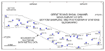
 | Figure 1. Index map of Cape Cod and the Islands showing location of the study area (red polygon). Blue arrows show directions of net sediment transport on the east-facing shores of Cape Cod and Nantucket (Strahler, 1988). |
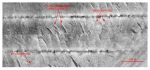
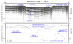 | Figure 2. Segment of high-resolution seismic-reflection Uniboom profile (O'Hara and Oldale, 1987) and interpretation of ASTERIAS 77024 line 35. Location of seismic profile shown in figure 22. |
 | Figure 3. Regional paleogeographic map of Cape Cod and the Islands showing the extent of the Laurentide ice sheet about 20 ka. Map modified from Oldale and Barlow (1986). |
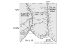
 | Figure 4. Regional paleogeographic map of Cape Cod and the Islands showing the extent of the Laurentide ice sheet just prior to 18 ka and location of Glacial Lake Nantucket Sound. Map modified from Oldale and Barlow (1986). |
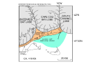
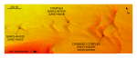
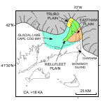 | Figure 5. Regional paleogeographic map of Cape Cod and the Islands soon after 18 ka. Map shows the extents of the Laurentide ice sheet, Glacial Lake Cape Cod Bay, and the Wellfleet, Truro, and Eastham outwash plains. Map modified from Uchupi and others (1996). |
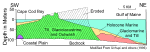 | Figure 6. Schematic geologic cross section of the Eastham Plain on outer Cape Cod. Diagram, which is modified from Uchupi and others (1996), shows the extent of erosional modification by marine processes during the Holocene sea-level rise and framework for exposed glacial drift. |
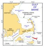
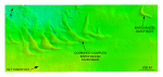
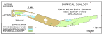
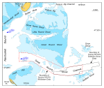 | Figure 7. Map showing the major physiographic features in the vicinity of the study area (National Oceanic Atmospheric Administration, 1996). Map also shows the extents of the multibeam bathymetry and sidescan-sonar datasets and the maximum strengths and directions of ebb tidal flow in the channels. |
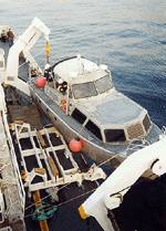 | Figure 8. Image showing NOAA Launch 1014 being deployed from the NOAA Ship THOMAS JEFFERSON. |
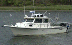
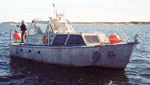 | Figure 9. Image showing a starboard-side view of NOAA Launch 1014 afloat. |
 | Figure 10. Port-side view of the NOAA Ship THOMAS JEFFERSON at sea. Note that the 30-foot survey launch normally stowed on this side of the ship has been deployed. |
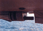
 | Figure 11. Image showing the Reson 8125 multibeam transducer mounted to the hull of the NOAA Launch 1014. |
 | Figure 12. Image showing the Reson Seabat 8101 hull mounted in the keel cut out of NOAA Launch 1005. |
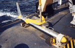 | Figure 13. Image showing a Klein 5000 sidescan-sonar towfish shown on the deck of the NOAA Ship THOMAS JEFFERSON. |
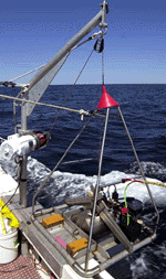
 | Figure 14. CTD (conductivity-temperature-depth) profiler shown on the deck of the NOAA ship THOMAS JEFFERSON. Data derived from frequent deployments of this device were used to perform sound velocity corrections on the multibeam data. |
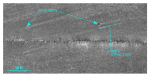
 | Figure 15. Map showing the station locations used to verify the acoustic data with bottom sampling and photography during the RAFAEL 06005 cruise. |
 | Figure 16. Image shows a port-side view of the USGS research vessel RAFAEL that was used to collect bottom photography and sediment samples in Great Round Shoal Channel, offshore Massachusetts. |
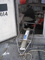
 | Figure 17. View of the small SEABOSS, a modified Van Veen grab equipped with still and video photographic systems. |
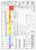 | Figure 18. Correlation chart showing the relationships between phi sizes, millimeter diameters, size classifications (Wentworth, 1922), and ASTM and Tyler sieve sizes. Chart also shows the corresponding intermediate diameters, grains per milligram, settling velocities, and threshold velocities for traction. |
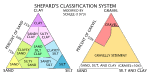 | Figure 19. Sediment classification scheme from Shepard (1954), as modified by Schlee (1973). |
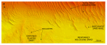
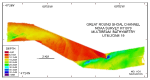 | Figure 20. Digital terrain model (DTM) of the sea floor produced from multibeam bathymetry collected during NOAA survey H11079 of Great Round Shoal Channel, offshore Massachusetts. Image is sun-illuminated from the north and vertically exaggerated 5x. Hotter colors are shallower areas; cooler colors are deeper areas. See key for depth ranges. |
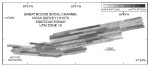 | Figure 21. Map showing the sidescan-sonar imagery produced from data collected during NOAA survey H11079 of Great Round Shoal Channel, offshore Massachusetts. Light tones are hard returns and generally coarser grained sediments; dark tones are softer returns and generally finer grained sediments. Tonal artifacts caused by inaccurate across-track normalization during processing complicate interpretation of the sidescan-sonar imagery.
|
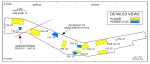 | Figure 22. Map showing the boundary of the acoustic data from NOAA survey H11079 of Great Round Shoal Channel and the locations of the detailed planar, perspective, and comparative views of the multibeam DTM and sidescan-sonar mosaic shown in other figures, and the seismic profile shown in figure 2. |
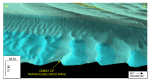
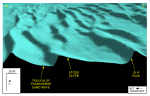
 | Figure 23. Detailed planar view of exposed glacial drift and the sand waves at the transition from shoal to channel from the DTM produced during NOAA survey H11079. Note that crest-line bifurcations are most common along the edge of a sand-wave field and that boulders are present on the exposed surface of the glacial drift. Location of view is shown in figure 22; depth key is shown in figure 20. |
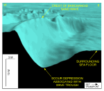
 | Figure 24. Detailed planar view of scour depressions flanking the southeastern tip of Great Round Shoal from the DTM produced during NOAA survey H11079. Note that the scour depression northeast of the tip is deeper and larger. Location of view is shown in figure 22; depth key is shown in figure 20. |
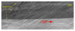
 | Figure 25. Detailed planar view of a comet structure associated with a boulder from the sidescan-sonar mosaic produced during NOAA survey H11079. Higher backscatter within this feature shows that coarser grained sediment is present there; scour asymmetry indicates that net transport is to the northeast. Location of view is shown in figure 22. |
 | Figure 26. Detailed planar view of the sidescan-sonar mosaic produced during NOAA survey H11079 showing the current-swept appearance that characterizes much of the eastern part of the study area. Note the isolated patches of megaripples. Location of view is shown in figure 22. |
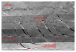
 | Figure 27. Detailed planar view of the sidescan-sonar mosaic produced during NOAA survey H11079 showing relatively straight to sinuous alternating bands of high and low backscatter ("tiger-stripe") pattern indicative of transverse sand waves. Note presence of megaripples on the stoss slopes indicative of active transport. Location of view is shown in figure 22. |
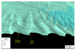
 | Figure 28. Detailed planar view of the barchanoid sand waves near the western end of Great Round Shoal Channel from the DTM produced during NOAA survey H11079. Note that wave orientation indicates net eastward transport, and that the waves become more complex downcurrent. Location of view is shown in figure 22; depth key is shown in figure 20. |
 | Figure 29. Detailed planar view of the barchanoid sand waves near the northeastern end of Great Round Shoal Channel from the DTM produced during NOAA survey H11079. Note that wave orientation indicates net eastward transport. Location of view is shown in figure 22; depth key is shown in figure 20. |
 | Figure 30. Figure 30. Detailed planar view of the sidescan-sonar mosaic produced during NOAA survey H11079 showing curved alternating bands of high and low backscatter ("tiger-stripe") pattern indicative of individual and complex barchanoid sand waves. Note presence of megaripples on the stoss slopes indicative of active transport. Location of view is shown in figure 22. |
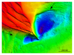
 | Figure 31. Detailed perspective view looking north of the barchanoid sand waves near the western end of Great Round Shoal Channel from the DTM produced during NOAA survey H11079. Note that orientation indicates net eastward transport, and that the troughs are scoured below the surrounding sea floor. Scale bars are only valid in the foreground; location of view is shown in figure 22.
|
 | Figure 32. Detailed perspective view looking south of the transverse sand waves along the southern edge of Great Round Shoal from the DTM produced during NOAA survey H11079. Note that wave asymmetry and slip face orientation indicate net eastward transport. Scale bars are only valid in the foreground; location of view is shown in figure 22. |
 | Figure 33. Detailed perspective view looking north of the transverse sand waves adjacent to the southeastern tip of Great Round Shoal from the DTM produced during NOAA survey H11079. Note that wave asymmetry and slip face orientation indicate net eastward transport. Scale bars are only valid in the foreground; location of view is shown in figure 22. |
 | Figure 34. Detailed planar view of the symmetrical sand waves in the central part of Great Round Shoal Channel from the DTM produced during NOAA survey H11079. Wave crests within this field parallel the axis of channel. Location of view is shown in figure 22; depth key is shown in figure 20. |
 | Figure 35. Detailed perspective view looking north of the transverse sand waves near the south-central part of Great Round Shoal Channel from the DTM produced during NOAA survey H11079. Note that wave asymmetry and slip face orientation indicate net westward transport. Scale bars are only valid in the foreground; location of view is shown in figure 22. |
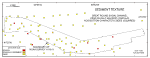 | Figure 36. Map showing the station locations used to verify the acoustic data color coded for sediment texture. Hotter colors are coarser grained sediment; cooler colors are finer grained sediments. See key for sediment classifications. |
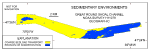 | Figure 37. Map showing the interpreted distribution of sedimentary environments within NOAA survey H11079. See key for environments. |
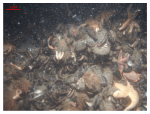 | Figure 38. Bouldery sea floor in the scour depression adjacent to the southeastern tip of Great Round Shoal. Blue mussels cover the boulders; crabs and starfish are common. Location of station is shown in figure 15. |
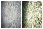 | Figure 39. Bottom photographs showing gravel that armors the sea floor in areas characterized by sedimentary environments of erosion or nondeposition and the presence of exposed glacial drift. A) Station GRS-8. B) Station GRS-35. Station locations are shown in figure 15. |
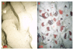 | Figure 40. Bottom photographs showing current-rippled sand that is prevalent in areas characterized by sedimentary environments of coarse bedload transport. A) Station GRS-13. B) Station GRS-17. Note the presence of abundant sand dollars. Station locations are shown in figure 15. |
 | Figure 41. Interpretation of the DTM and sidescan-sonar mosaic from NOAA survey H11079 of Great Round Shoal Channel. Shown are the areas characterized by exposed glacial drift, transverse sand waves, and barchanoid sand waves. White areas within the study area are primarily relatively flat and megarippled reworked Holocene sand. |
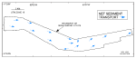 | Figure 42. Map showing the interpreted directions of net sediment transport (blue arrows). Interpretation is based on the orientation and asymmetry of sand waves and scour marks. Note that sediment transport is generally to the east. |
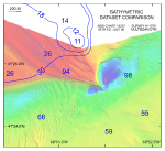 | Figure 43. Detailed comparative view of the new multibeam bathymetric dataset with contours and soundings from chart 13237 (NOAA, 1996). Note that the southeastern tip of Great Round Shoal and its associated scour depressions have migrated dramatically to the southeast. Depth key for multibeam bathymetry is shown in figure 20. |


