
Woods Hole Science Center
Sea-Floor Character and Sedimentary Processes of Great Round Shoal Channel, Offshore Massachusetts
![]() Title |
Introduction |
Setting |
Methods |
Overview |
Discussion |
Interpretation |
Data Catalog |
Acknowledgments |
References |
Figures |
Bottom Photographs |
Sediment Data |
Contacts
Title |
Introduction |
Setting |
Methods |
Overview |
Discussion |
Interpretation |
Data Catalog |
Acknowledgments |
References |
Figures |
Bottom Photographs |
Sediment Data |
Contacts
 |
||
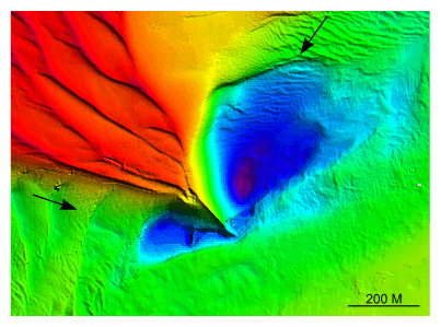
Figure 24. Detailed planar view of scour depressions flanking the southeastern tip of Great Round Shoal from the DTM produced during NOAA survey H11079. Note that the scour depression northeast of the tip is deeper and larger. Location of view is shown in figure 22; depth key is shown in figure 20. | ||


