Woods Hole Science Center
Sea-Floor Character and Sedimentary Processes of Great Round Shoal Channel, Offshore Massachusetts
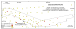
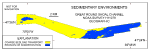
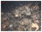
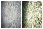
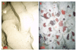
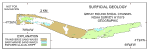
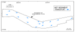
Distributions of surficial sediment, sedimentary environments, surface geology, and directions of net sediment transport were mapped within the study area. These interpretations represent dominant long-term conditions and do not reflect small-scale variation or intermittent processes. All contacts between the textural distributions and sedimentary environments should be considered inferred because the transitions between the various environments are typically gradational, and lateral changes are seldom abrupt. Surficial SedimentsGravel, including boulders, occurs at scattered locations in the eastern part of the study area, in scour depressions, and at the western entrance to Great Round Shoal Channel (fig. 36). These coarse deposits are primarily associated with outcrops of glacial drift, and are probably lag deposits that armor finer-grained underlying sediments. Bottom video shows that small scattered patches of sand locally occur among boulders and that gravelly sand is concentrated in the troughs of larger bedforms. Sand is the dominant sediment textural class in the areas characterized by large bedforms (i.e., sand waves and megaripples) and reworked Holocene sediment. The sand is typically medium to very coarse grained and moderately to moderately well sorted. Finer grained sediment is rare or absent. Sedimentary EnvironmentsTwo distinct sedimentary environments are mapped within the study area and include areas of the sea floor characterized by erosion or nondeposition and by coarse bedload transport (fig. 37). Environments characterized by erosion or nondeposition, which reflect high-energy conditions (Knebel and Poppe, 2000), prevail across the eastern part of the study area and at the western entrance to Great Round Shoal Channel. There, strong tidal currents and storm-driven waves prevent the deposition of Holocene marine sediments and erode the finer fraction from the sea-floor sediments, leaving exposed lag deposits of boulders and gravel. Sessile flora and fauna (i.e., seaweed, sponges, soft corals, and mussels) obscure the rock surfaces in bouldery areas (fig. 38). Barnacles and other encrusting forms cover the rock surfaces of gravel pavements, but larger sessile forms are absent suggesting that the gravel is periodically mobilized (fig. 39). Conditions favoring erosion or nondeposition are replaced by sedimentary environments characterized by coarse bedload transport in areas where sediment supply is more abundant and energy levels are slightly lower. This environment, which is defined by sand waves and megaripples, is prevalent across the western part of the study area in that part of the channel between Great Round Shoal and Point Rip (fig. 37). The sediments are predominantly coarse, moderately sorted sand. Ripples are ubiquitous on the sand-wave and megaripple stoss surfaces, and sand dollars are common in the bottom video (fig. 40). Surficial GeologyMapped distributions of exposed glacial deposits and sand-wave morphologies are shown in figure 41. The exposed glacial deposits were identified based on the presence of boulders, irregular isolated ridges, and a hummocky appearance. These deposits dominate the eastern half of the study area and occur in smaller areas at the western entrance to the Channel. Transverse sand waves have relatively straight to slightly sinuous crest lines. These bedforms dominate where the sand supply is abundant, such as the west-central part of the study area and along the edges of Great Round Shoal and Point Rip. Barchanoid sand waves are crescent shaped and tend to form where sand supply is limited. These bedforms are found near the western end on the study area and along its northern edge east of the southeastern tip of Great Round Shoal. White areas within the survey area shown in figure 41 depict areas of relatively flat sea floor and areas of megaripples without sand waves. Sediment TransportOrientation and asymmetry of the barchanoid and transverse sand waves indicate net sediment transport is eastward along the axis of Great Round Shoal Channel (fig. 42). Asymmetry of megaripples on the stoss slopes of sand waves and of scour marks around nearby boulders also indicates net eastward transport. The abundance and amplitude of transverse and barchanoid sand waves reflect the action of strong bottom currents in Great Round Shoal Channel. The presence of current ripples and megaripples on these sand waves and the steepness of the slip faces suggest that this transport is active and that the sand waves are propagating under the present hydraulic regime (Dalrymple and others, 1978; Reineck and Singh, 1980; Allen, 1982). Although current ripples may reverse their orientation during semidiurnal tidal cycles because of the small volume of the ripples, no reversal in either the sand-wave or megaripple morphology or orientation was observed in the multibeam or sidescan-sonar data of adjacent lines collected at different tidal stages. Whether this tidal independence of large bedform orientation is due to the spatial distribution of residual currents, or to an asymmetry of current velocities is also uncertain, but it does suggest that the larger bedforms are more stable and that they move over longer time scales. While sand-wave asymmetry in the bathymetric data reveals long-term direction of transport, no information on the rate of advance is supplied. However, comparisons of the present acoustic datasets with the existing nautical chart for the approaches to Nantucket Sound (NOAA, 1996) show distinct changes in the morphology of sea-floor features. For example, the southeastern tip of great Round Shoal and its associated scour depressions have propagated over 0.6 km to the southeast since the prior bathymetric survey (H08171) was completed during 1954. (fig. 43). |
Click on figures for larger images.
|
![]() Title |
Introduction |
Setting |
Methods |
Overview |
Discussion |
Interpretation |
Data Catalog |
Acknowledgments |
References |
Figures |
Bottom Photographs |
Sediment Data |
Contacts
Title |
Introduction |
Setting |
Methods |
Overview |
Discussion |
Interpretation |
Data Catalog |
Acknowledgments |
References |
Figures |
Bottom Photographs |
Sediment Data |
Contacts