
Center News, December 2014
VIPS Learn about Climate Change Impacts along San Francisco’s Outer Coast
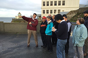
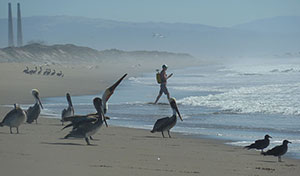
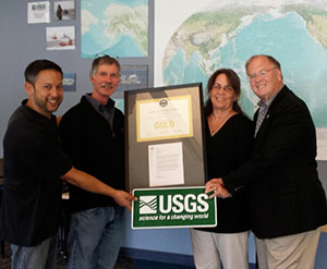
San Francisco Mayor Ed Lee and Secretary of the Interior Sally Jewell (2nd and 3rd from left), and Acting USGS Director Suzette Kimball (far right, foreground), listen to USGS research geologist Patrick Barnard, far left, as he leads a field trip on the cliffs above Ocean Beach, San Francisco. This narrow stretch of coast is exposed to the brunt of the North Pacific Ocean wave climate.
Secretary of the Interior Sally Jewell, Acting USGS Director Suzette Kimball, and San Francisco Mayor Ed Lee took part in a coastal climate change field trip led by USGS research geologist Patrick Barnard on December 18, 2014. The field trip visited two beaches along the outer coast of the San Francisco Peninsula that are within the most rapidly eroding stretch of California’s coast. Erosion is currently driven primarily by human influences on sand supply, but projected climate-change impacts, including sea-level rise and extreme storms, will increase the vulnerability of this urbanized coast to beach erosion, cliff failures, and coastal flooding, posing threats to private and public infrastructure, including a state highway and a $1.2-billion wastewater-treatment plant. The USGS has been active in understanding the various coastal processes that control this important section of coastline. For more information, contact Patrick Barnard, [email protected], 831-460-7556.
New Bivalve Species Discovered in Arctic Ocean Sediment
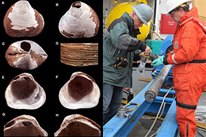
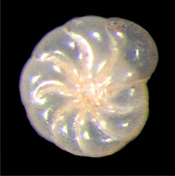
At left, photographs of the new species Wallerconcha sarae, identified by Paul Valentich-Scott (Photo Credit: Valentich-Scott) [Larger version]. At right, USGS chief scientist Brian Edwards, with USGS researcher Andy Stevenson, collecting samples from the gravity corer. on board Cutter Healy (Photo Credit: Helen Gibbons) [Larger version].
A new species of bivalve mollusk (clams, mussels, oysters, and their kin) was discovered more than 2.5 kilometers (1.5 miles) below the Arctic Ocean surface off northern Alaska. The new species was found in sediment cores that penetrated over 4.5 meters (15 feet) into an unusual seafloor mound. Age estimates place the clam as living as much as 1.8 million years ago to near present; it might still be alive today. USGS scientists aboard the U.S. Coast Guard Cutter Healy collected the cores in 2010 during a joint U.S.-Canadian cruise to map the limits of U.S. and Canadian Extended Continental Shelf. The animal was identified as a new genus and species by Paul Valentich-Scott of the Santa Barbara Museum of Natural History. Named Wallerconcha sarae, it was reported in the open-access journal ZooKeys (doi:10.3897/zookeys.462.6790). For more information, contact Tom Lorenson, [email protected], 831-460-7410.
View larger versions of the photographs:
Wallerconcha sarae, and USGS researchers Brian Edwards and Andy Stevenson.
Visit the 2010 Extended Continental Shelf Survey web site at http://continentalshelf.gov/missions/10arctic/welcome.html
Mapping Fault Deformation and Large Submarine Landslides Off Southern California
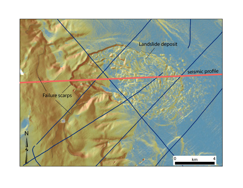
Shaded relief bathymetry draped draped by slope gradient (warm colors= steep; cool colors = gentle). Submarine headwall and sidewall scarps delineate several large landslide evacuation zones and their associated deposits along the floor of Santa Cruz Basin. Slides face the mainland shoreline of Santa Monica and Redondo Beach. Red line is a seismic reflection profile.
To better understand offshore earthquake and tsunami hazards, USGS scientists from the Pacific Coastal and Marine Science Center (PCMSC) and the Woods Hole Coastal and Marine Science Center ran a multichannel seismic survey off southern California in late November. Led by PCMSC, the research cruise was a collaborative effort between USGS, Scripps Institution of Oceanography, and University of California, Santa Cruz. It produced detailed images of
- Holocene and late-Pleistocene deformation associated with three offshore faults, and
- large submarine landslides along a ridgeline facing Santa Monica.
The three faults—San Clemente fault, Catalina fault, and San Diego Trough fault—combined accommodate 10�15% of the North America-Pacific plate motion (5�7 mm/yr). Results of the survey will contribute to probabilistic hazards models for metropolitan Los Angeles and San Diego. For more information, contact Danny Brothers, [email protected], 831-460-7460.
Read more about our “U.S. West Coast and Alaska Marine Geohazards.”
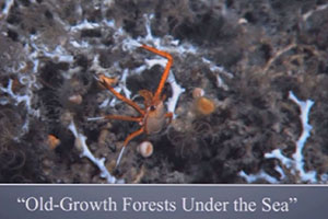
Extreme Longevity and Slow Growth Rates of Deep-Sea Corals in Area Affected by Deepwater Horizon Oil Spill Highlight Vulnerability
Chrysogorgia sp. coral being collected on October 15, 2011, at a depth of 1,094 meters or 3,600 feet in the Gulf of Mexico from the vessel Holiday Chouest using the Schilling ultra-heavy-duty remotely operated vehicle. Image was acquired with an AquaPix AquaSLR digital still camera held by the ROV manipulator arm. Photo courtesy of Penn State Professor of Biology Charles Fisher.
USGS scientists Nancy Prouty (PCMSC) and Amanda Demopoulos and academic colleagues published “Growth rates and ages of deep-sea corals impacted by the Deepwater Horizon oil spill” in Deep-Sea Research II in November 2014 (doi: 10.1016/j.dsr2.2014.10.021). The authors report growth rates based on deep-sea (> 800 meters) corals collected in 2010 and 2011 from an area affected by the Deepwater Horizon (DWH) spill. Using radiocarbon dating methods, they report life spans of over 600 years. These slow-growing corals yield radial growth rates between 0.34 and 14.20 micrometers/year. Low radiocarbon values for some corals' soft tissue indicate they were feeding in part on petroleum-derived carbon, potentially related to the DWH spill. The extreme longevity and slow growth rates highlight the vulnerability of these deep-sea coral species to disturbance. For more information, contact Nancy Prouty, [email protected], 831-460-7526.
3D Study of Fault Junction Featured on KQED Science Blog
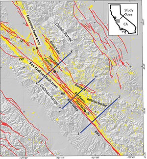
Figure 1 from USGS Tectonics paper on the junction between the San Andreas and Calaveras faults, reprinted in a KQED blog about the paper. Red lines are active faults; yellow dots are earthquake locations; H marks the town of Hollister. The three lines X-X’, Y-Y’ and Z-Z’ are locations of cross sections from the paper that are also reprinted in the blog.
A recent Tectonics paper by USGS scientists studying the junction between California’s San Andreas and Calaveras faults was featured in a KQED Science Blog. Blog author Andrew Alden described how USGS geophysicist Janet Watt and colleagues combined geologic and geophysical data to develop a 3D picture, or model, of the fault junction.
Alden selected graphics from the paper (doi: 10.1002/2014TC003561) to show how the model reveals two cross faults that may connect the San Andreas and Calaveras faults at depth. He echoes the authors’ comments about the importance of 3D fault investigations when he writes, “Because earthquakes can spread from one major fault to another, these are the things we need to find if we want to learn our earthquake future.”
KQED is a public media outlet based in San Francisco, California. For more information, contact Janet Watt, [email protected], 831-460-7565.
Highlights from the Sound Waves Newsletter, Published December 2014
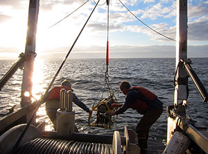
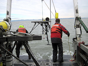
Free-Ascending Tripod Brings Data from the Deep Seafloor of the South China Sea
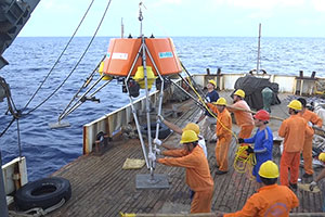 A deepwater tripod system designed and built at the U.S. Geological Survey Pacific Coastal and Marine Science Center in Santa Cruz, California, was recovered in late September 2014 after spending 5 months collecting data on the floor of the South China Sea. The Free-Ascending Tripod (FAT) was deployed in April 2014 at 1,900 meters (6,200 feet) water depth—roughly 10 times as deep as most tripods dedicated to measuring currents and sediment movement at the seafloor.
Data and discoveries from this project will be at the forefront of deepwater marine-geology research for the region and probably for the world. Practical applications include choosing favorable sites for undersea cables and other infrastructure.
Read more in the Sound Waves Newsletter.
Postdocs Contributing to Climate-Change Studies at the USGS Pacific Coastal and Marine Science Center
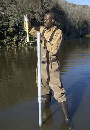
Kingsley Odigie, currently a University of California, Santa Cruz/USGS Postdoctoral Scholar, takes groundwater-well measurements before deploying a CTD (conductivity, temperature, depth) probe at the Younger Lagoon Reserve in Santa Cruz, California, in December 2012.
Three new postdoctoral researchers have joined the U.S. Geological Survey (USGS) Pacific Coastal and Marine Science Center in Santa Cruz, California. Their efforts support the Coastal Climate Change Impacts project.
Kingsley Odigie is a University of California, Santa Cruz (UCSC)/USGS Postdoctoral Scholar working with USGS research oceanographer Peter Swarzenski and USGS research geologist Jon Warrick. He is investigating the impacts of climate change on coastal flooding near river mouths and on groundwater aquifers along the California coast.
Patrick Limber is a USGS Mendenhall Research Fellow developing an approach for predicting multi-decadal cliff retreat due to climate change. He works primarily with USGS research oceanographer Li Erikson and USGS research geologist Patrick Barnard. Pat’s expertise lies in large-scale, long-term coastline evolution, beach and sea-cliff dynamics, nonlinear dynamics, and coastal management.
Sean Vitousek is also a Mendenhall Research Fellow working primarily with Li Erikson and Patrick Barnard. He is developing an approach for predicting multi-decadal sandy beach evolution due to climate change. Sean’s expertise lies in numerical modeling, computational efficiency, nearshore processes, and internal waves.
Read more in the Sound Waves Newsletter.
Coastal Streams in Central California Reflect the Region�s Drought
 In the western United States water is not as abundant as in many other parts of the country; in some periods, less rain falls and water is even scarcer. We are now in one of those periods: 2013 was the driest calendar year on record for the state of California, prompting Governor Jerry Brown to declare a drought state of emergency on January 17, 2014.
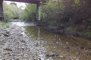
USGS personnel in the California Water Science Center’s Santa Cruz Field Office monitor streams along the central California coast from Pilarcitos Creek at Half Moon Bay to the Salinas River in Paso Robles.
The effects of California’s drought are vividly illustrated in the discharge data from streams in the Santa Cruz area. The primary concern in drought is that we have enough water for drinking and for such everyday activities as washing and watering, but having abnormally low amounts of water in a river causes other concerns as well. In addition to human consumption, water is necessary to maintain life both in rivers (aquatic) and in areas adjacent to rivers (riparian). Steelhead trout, for example, spawn in the San Lorenzo River, Pescadero Creek, and other central California coastal streams. When the river runs dry, the fish cannot get back to their spawning grounds.
Read more in the Sound Waves Newsletter.
USGS Scientist Participates in National Geographic’s BioBlitz 2014
 On March 28–29, 2014, more than 300 professional scientists, 2,700 school children, and countless citizen scientists participated in BioBlitz 2014—an attempt to find and identify as many plants and animals as possible within a 24-hour period in the Golden Gate National Recreation Area (GGNRA), located near San Francisco, California. The event was sponsored by National Geographic, the National Park Service, Golden Gate National Parks Conservancy, and the Presidio Trust. Teams of volunteer scientists, families, students, teachers, and other community members worked together to fulfill the goals of BioBlitz:
- discover, count, map, and learn about the living creatures in the park;
- provide scientists and the public an opportunity to do fieldwork together;
- add to the park’s official species list; and
- highlight the importance of protecting biodiversity in these extraordinary places and beyond.
The biological inventories were conducted in the Giacomini Wetlands at Point Reyes National Seashore, Muir Woods National Monument, Fort Point National Historic Site, Muir Beach, the Marin Headlands, Crissy Field, the Presidio, Mori Point, Rancho Corral de Tierra in Montara, and other nearby locations.
Read more in the Sound Waves Newsletter.
Twenty Years of Ask-A-Geologist
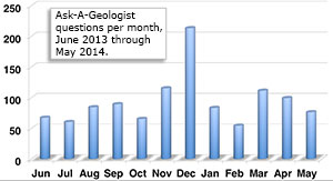 Since October 4, 1994, the U.S. Geological Survey USGS Ask-A-Geologist (AAG) project has answered Earth science questions for roughly 60,000 people.
We get questions from young children, students, teachers, professionals, and the general public, who enjoy getting answers directly from USGS scientists. Anyone can send questions by email, through the AAG Web site.
Read more in the Sound Waves Newsletter, or visit the Ask-A-Geologist Web site.
USGS Coastal and Marine Geology Program Science Centers Team Up for Feds Feed Families Food Drive
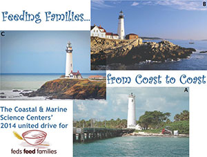
Lighthouses located near Coastal and Marine Geology Program science centers, including A, Egmont Key Light at the mouth of Tampa Bay near St. Petersburg, Florida; B, Nobska Light near Falmouth, Massachusetts; and C, Pigeon Point Lighthouse between San Francisco and Santa Cruz, California. [Larger version]
For the last several years, the three science centers of the USGS Coastal and Marine Geology Program have had a friendly competition to see who could contribute the most pounds of food during the summer food drive. The initial competition was proposed by Fran Lightsom at the USGS Woods Hole Coastal and Marine Science Center and quickly embraced by Andrea Toran (Woods Hole), Carolyn Degnan of the Pacific Coastal and Marine Science Center , and Molly McLaughlin of the St. Petersburg Coastal and Marine Science Center, all of whom serve as volunteer local coordinators. The winning center had bragging rights for the following year, and the competition became a great tool for motivating employees during each summer's collection drive.
Read more in the Sound Waves Newsletter.
Field Investigations at Fire Island, New York, to Better Understand Hurricane Sandy�s Impacts and Support Studies of Coastal Resilience
 In response to Hurricane Sandy, which struck the U.S. east coast in October 2012, the USGS is engaged in a research project that examines the coastal dynamics of Fire Island, a 50-kilometer (30 mile)-long barrier island south of Long Island, New York. The research will provide basic scientific information on coastal evolution and recovery, and will aid mitigation efforts and management planning.
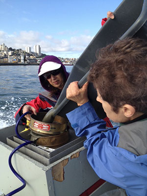
Personal-watercraft and GPS surveys were conducted by USGS personnel from the USGS Pacific Coastal and Marine Science Center in Santa Cruz, California (PCMSC) and other USGS colleagues. Pictured here, USGS PCMSC Engineering Technician Tim Elfers (far left) and USGS colleagues complete a beach launch of instrumented personal watercraft at Fire Island [larger version].
Read more in the Sound Waves Newsletter.
Center News, November 2014
Integrated Geologic and Geophysical Study of the San Andreas-Calaveras Fault Junction Reveals 3D Geometry and Connectivity

Major faults in the vicinity of Paicines, California, about 50 kilometers east of Monterey Bay. Shaded box shows area where the San Andreas and Calaveras faults intersect. [Larger version]
USGS research geophysicist Janet Watt and colleagues published an article in Tectonics (https://doi.org/10.1002/2014TC003561) on their use of potential-field, geologic, geodetic, and seismicity data to study fault geometry and slip transfer through the 60-kilometer-long junction of California�s San Andreas and Calaveras faults.
Among the major findings:
- seismically active cross faults connect the two faults at depth, suggesting that through-going earthquake rupture is possible and that the steeply dipping Calaveras fault zone should be considered in future seismic-hazard analyses;
- serpentinite and related rocks are widespread within the fault junction, which may help explain why the two faults creep in the junction.
The study highlights the need for 3D characterization of fault geometry at deep intersections of major faults that do not intersect at the Earth�s surface. For more information, contact Janet Watt, [email protected], 831-460-7565.
USGS Part of Multiagency Investigation that Discovered New Coral Species off California
 On November 5, NOAA announced the discovery of a new species of deep-sea coral and a nursery area for catsharks and skates in underwater canyons near the Gulf of Farallones and Cordell Bank national marine sanctuaries. The discoveries came during the first intensive exploration of California’s offshore areas north of Bodega Head by a consortium of federal and state marine scientists that included USGS geophysicist Guy Cochrane. They used small submersibles and other technologies to film and photograph marine life in waters reaching 1,000 feet deep. Cochrane, whose USGS team had collected sonar data in the area in 2011, noted: "The video surveys from this research mission verified the extent of rocky habitat estimated from sonar data collected several years ago."
Read the NOAA news release at http://www.noaanews.noaa.gov/stories2014/20141105_deepseacoral.html. For more information, contact Guy Cochrane, [email protected], 831-460-7554.
Shipwreck Discovered During Sampling Cruise in Monterey Bay, California
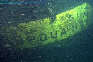
Above, view of the sunken barge Umpqua II.
Below, map of Monterey Bay and location of sunken barge. Photo and map courtesy of MBARI.
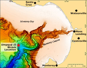
Scientists with the USGS and the Monterey Bay Aquarium Research Institute (MBARI) discovered a sunken barge during a weeklong sampling cruise in Monterey Bay, where they are studying sediment transport and natural hazards, including the offshore San Gregorio fault zone. USGS research geologist Katie Maier was examining sonar images from MBARI’s autonomous underwater vehicle (AUV) when she spotted angular features that suggested a manmade object in Monterey Canyon. The researchers—who were using MBARI’s remotely operated vehicle (ROV) Doc Ricketts to sample deep-sea sediment in the canyon—focused one dive on the angular object and discovered that it was the Umpqua II out of Reedsport, Oregon.
The barge ran aground in 1982 near Moss Landing and was towed out and sunk in the canyon, where it now lies nearly 1,700 meters (one mile) below the ocean surface.
Read about the discovery at MBARI's web page. For more information, contact Katie Maier, [email protected], 831-460-7461.
Workshops on the California Seafloor and Coastal Mapping Program
 On October 22 and 23, 2014, the USGS, the California Ocean Protection Council, and the National Oceanic and Atmospheric Administration (NOAA) co-hosted two workshops on the California Seafloor and Coastal Mapping Program (CSCMP) at the USGS Pacific Coastal and Marine Science Center in Santa Cruz, California. CSCMP scientists are currently publishing a comprehensive geologic and habitat base-map series for all of California's State waters, and they are seeking feedback on how the program should go forward to best fit diverse scientific and stakeholder needs. Each workshop was attended by 45 to 50 participants, with representation from 32 different entities, including 9 state agencies, 8 federal agencies, 5 academic/research institutions, 3 regional associations, 3 non-governmental organizations, and 7 private-sector companies. The breadth of interests and expertise led to enthusiastic and fruitful discussions. For more information, contact Sam Johnson ([email protected], 831-460-7546) or Guy Cochrane ([email protected]; 831-460-7554).
Mapping Changes in Beach Landscapes along Northern Monterey Bay, California
 From October 20–24, scientists from the USGS Pacific Coastal and Marine Science Center surveyed local beaches and the nearby ocean bottom to compile a three-dimensional map of how beaches change in northern Monterey Bay. The surveys were conducted from Santa Cruz to Moss Landing with instruments mounted on all-terrain vehicles, personal watercraft, and backpacks carried on foot. This was the first in a series of surveys that will be repeated seasonally and annually to provide a detailed picture of how the coastline reacts to changes in waves, currents, and sediment input. The mapping will be enhanced by aerial video plus data from time-lapse cameras and tide and wave gauges attached to local piers. Results can be incorporated into future scenarios of sea-level rise and climate change, helping Monterey Bay communities determine how and what to protect along their coastlines. For more information, contact Jon Warrick, [email protected], 831-460-7569 or Patrick Barnard, [email protected], 831-460-7556.
Center News, October 2014
USGS to Participate in Inter-Agency Sea-Level Rise Panel Discussion
 USGS scientists Patrick Barnard (Pacific Coastal and Marine Science Center, California) and Nathaniel Plant (St. Petersburg Coastal and Marine Science Center, Florida) will serve as subject matter experts in an Inter-Agency Sea-Level Rise Panel Discussion hosted by the Federal Emergency Management Agency (FEMA) on October 16, 2014. During the past 10 years, multiple hurricanes have caused billions of dollars in damage and much human suffering. Climate change and sea-level rise have received much attention as the Nation strives for improved resiliency. FEMA Risk Mapping, Assessment and Planning (Risk MAP) Federal Coastal Partners are analyzing potential impacts of sea-level rise, and supporting disaster planning for coastal states and communities. Barnard and Plant will bring their expertise in sea-level rise forecasts to a discussion panel including members from FEMA, EPA, NOAA, and USACE. For more information, contact Patrick Barnard, [email protected], 831-460-7556.
 Free-Ascending Tripod Brings Data from Deep Seafloor of South China Sea
The Free Ascending Tripod (FAT) designed and built at the USGS Pacific Coastal and Marine Science Center was recovered in late September after spending 5 months on the floor of the South China Sea collecting data with acoustic and optical instruments. FAT was deployed in April 2014 at 1,900 meters (6,200 feet) water depth in a cooperative project with scientists from Tongji University (Shanghai, China) to better understand how and where deep-seafloor sediment moves and accumulates. Discoveries from this project, one of only a few such studies conducted outside of the oil industry, will be at the forefront of deep-water marine-geology research for the region and probably for the world. Practical applications include choosing favorable sites for undersea cables and other infrastructure. Read about FAT at http://soundwaves.usgs.gov/2013/08/fieldwork2.html. For more information, contact George Tate, [email protected], 831-460-7484.
BOEM-Funded Mapping for Proposed Wind Farm Offshore Oregon
 Guy Cochrane, Peter Dartnell, and others from the USGS Pacific Coastal and Marine Science Center, with collaborator Lenaig Hemery of Oregon State University, mapped the seafloor in an area off Coos Bay, Oregon,under consideration for construction of a floating wind-energy facility. Using USGS research vessel Parke Snavely, they collected high-resolution bathymetry and backscatter, high-definition video, and still photos in August–September 2014. The data are being used to develop a digital elevation model (DEM), habitat maps, and geologic maps needed by the Bureau of Ocean Energy Management (BOEM) for marine spatial planning, ecosystem assessment, environmental reviews, and offshore infrastructure analysis. BOEM, which funded the study, will use this information for decisions about the proposed WindFloat Pacific 30-megawatt floating wind farm—the first wind farm proposed offshore of the U.S. west coast. For more information contact Guy Cochrane, [email protected], 831-460-7554.
New USGS Benthic OBservation Sled (BOB Sled) High-Definition Seafloor Video Camera System
 The USGS Marine Facility (MARFAC) in Santa Cruz, California, has developed a tethered instrument package called the Benthic OBservation Sled or “BOB Sled,” which can acquire video and other data as much as 700 meters (2,300 feet) below the sea surface. The system’s first use was in August–September 2014, when it collected imagery of the seafloor off Coos Bay, Oregon, in an area under consideration for the construction of a floating wind-energy facility. Designed for deployment from the 34-foot research vessel Parke Snavely, the system is remotely controlled from the vessel while it gathers data from multiple instruments that can be configured as needed for a particular science project. Video and data are transmitted and recorded on the surface vessel in real time. For more information, contact Gerry Hatcher, [email protected], 831-460-7524.
Coastal Defense Tool Wins United Nations Award
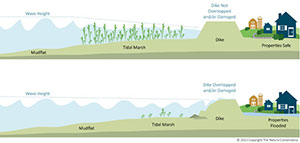
Healthy tidal marsh (upper panel) reduces storm-wave heights, allowing levee to protect property. Degraded tidal marsh (lower panel) allows storm waves to erode and overtop levee.
The Coastal Defense app, a module of the Coastal Resilience Tool developed by The Nature Conservancy in collaboration with the USGS and other partners, received the top award for a scientific application addressing disaster and resilience planning at the September 23, 2014, United Nations Climate Summit in New York. Climate change is putting coastal communities at greater risk of erosion and flooding. The Coastal Defense app allows users to:
- identify areas at risk of coastal erosion and inundation from waves, sea-level rise, and storm surge,
- examine the role of coastal habitats—such as tidal wetlands—in attenuating wave height and energy, and
- determine adaptation strategies that incorporate natural as well as man-made protections.
Access the Coastal Defense tool at http://maps.coastalresilience.org/pugetsound/.
Read details and view a demo video at https://www.hackerleague.org/hackathons/esri-global-disaster-resilience-app-challenge-2014/hacks/coastal-defense-professional.
For more information, contact Eric Grossman, [email protected], 206-526-2529.
California Congresswoman Attends USGS Talk on Applying Climate-Change Science to Coasts
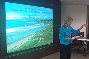 On October 1, 2014, Congresswoman Lois Capps, whose district (24th) includes more than 200 miles of the central California coast, attended a talk on climate-change science by research geologist Patrick Barnard of the USGS Pacific Coastal and Marine Science Center. The talk was given at the Santa Barbara Coastal Ecosystems Vulnerability Workshop at City Hall in Goleta, California. Upon her arrival at the workshop, Congresswoman Capps said a few words in support of research on climate impacts and the need to plan for those impacts now. Then she listened attentively to Barnard’s hour-long presentation summarizing the latest in climate-change science as it applies to the coast and describing how the USGS Coastal Storm Modeling System (CoSMoS) is meeting heavy demands for data on California coastal climate-change impacts. For more information, contact Patrick Barnard, [email protected], 831-460-7556.
Center News, September 2014
Briefing on deep coral reefs for the Trustee Council for the Deepwater Horizon oil spill
 On September 18, 2014, Nancy Prouty of the USGS Pacific Coastal and Marine Science Center gave a briefing to the Trustee Council for the Deepwater Horizon oil spill (of which USGS and NOAA are members) and the Department of Justice. The briefing was part of a 3-day meeting hosted by the NOAA Center for Coastal Environmental Health and Biomolecular Research in Charleston, SC. Prouty gave a short presentation on age and growth of mesophotic reefs (light-dependent coral ecosystems living at depths of 60 meters to more than 100 meters) to the Natural Resource Damage Assessment (NRDA) Trustees of Mesophotic Reefs (specifically the Deepwater Benthic Communities Technical Working Group). The meeting’s overall goal is complete documentation for NOAA’s Damage Assessment, Remediation, and Restoration Program (DARRP). For more information, contact Nancy Prouty, [email protected], 831-460-7526.
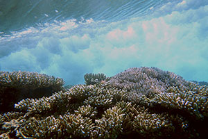
USGS Scientist Briefs Office of Insular Affairs on Coral Reef Issues in the Pacific
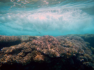
Underwater view of a wave crashing over a coral reef on the low-lying Kwajalein Atoll (Republic of the Marshall Islands) illustrates how healthy coral reefs cause waves to break offshore and dissipate their energy before reaching the shoreline, lessening the probability of coastal erosion and inundation.
USGS research geologist Curt Storlazzi briefed Lori Faeth, DOI's Acting Assistant Secretary for Insular Affairs, during the U.S. Coral Reef Task Force (USCRTF) meeting on Maui, Hawaiʻi, 8-13 September 2014. Storlazzi explained USGS research on coral reef health and sustainability for fisheries and shoreline protection. A recent study co-authored by Storlazzi shows that coral reefs provide substantial protection against natural hazards by reducing wave energy that would otherwise impact coastlines. He also discussed USGS efforts to understand the likely impacts of sea-level rise and climate change on freshwater and agriculture on low-lying Pacific atolls, some of which have already experienced saltwater flooding related to sea-level rise and changing climate. For more information, contact Curt Storlazzi, [email protected], 831-460-7521.
Learn more about the USGS Coral Reef project
Learn more about the USGS study on Pacific atolls
New Project Website: “The Impact of Sea-Level Rise and Climate Change on Pacific Ocean Atolls”
 Pacific atolls and the people who live on them are well known to be among the most vulnerable to the impacts of future climate change and sea-level rise. The USGS is leading a multiagency project to assess the impacts of sea-level rise and storm-wave-induced overwash and inundation on small Pacific atoll islets and their freshwater resources under various sea-level rise and climatic scenarios. Current research is conducted on Roi-Namur Island on Kwajalein Atoll, which is in the Republic of the Marshall Islands, Pacific Ocean. The website highlights the project's goals, field techniques, climate modeling, and progress.
Please visit the Project website
Highlights from the latest issue of Sound Waves Newsletter
 Coral Reefs Along West-Central Guam—Historical Impact of Watershed Change and Sedimentation
By Nancy Prouty and Curt Storlazzi
“The goal of this study was to provide a historical perspective on sediment input to coral reefs adjacent to a watershed with a history of land-use change and determine the implications for future management policies,” explains lead scientist Nancy Prouty, a research oceanographer at the USGS Pacific Coastal and Marine Science Center in Santa Cruz, California.
Read the entire Sound Waves article.
 Geologic Evidence of Past Tsunamis in California
By Bruce Richmond, Rick Wilson (California Geological Survey), Eileen Hemphill-Haley (Humboldt State University), and Bruce Jaffe
An extensive sedimentary deposit formed by a tsunami in 1946 was recently discovered at Pillar Point Marsh near Half Moon Bay, California. Although there were photos and eyewitness accounts of the tsunami and resulting damage at the time, finding the tangible evidence in the geologic record is an important part of assessing the long-term hazard that tsunamis pose to California coastal communities. A better awareness of tsunami potential will help local authorities devise improved mitigation and evacuation plans.
Read the entire Sound Waves article.
 USGS Helps Celebrate the Monterey Bay National Marine Sanctuary
By Helen Gibbons
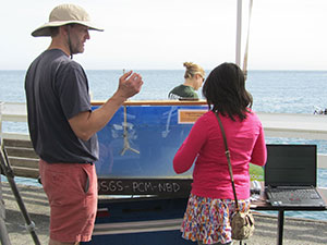
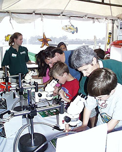
Visitors enjoyed interactive U.S. Geological Survey (USGS) displays at the Monterey Bay National Marine Sanctuary Celebration held May 17, 2014, on the municipal wharf in Santa Cruz, California. The family-oriented Sanctuary Celebration was one of a series of events marking the wharf’s 100th year. Among the many offerings were live music, arts and crafts, bird spotting, a boat-building demonstration, a treasure hunt for kids, and numerous informational booths.
Read the entire Sound Waves article.
 Public Lecture on Deep-Sea Corals Takes Audience “Into the Abyss”
By Helen Gibbons
U.S. Geological Survey (USGS) research oceanographer Nancy Prouty took her audience into the ocean depths for a look at deep-sea coral communities in a public lecture titled “Into the Abyss: Living Without Light” on June 26, 2014, at the USGS center in Menlo Park, California.
Read the entire Sound Waves article.
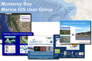 Spring 2014 Monterey Bay Marine GIS User Group Meeting
By Nadine Golden
The fourth meeting of the Monterey Bay Marine GIS User Group was held on April 14, 2014, in Monterey, California. A GIS (geographic information system) is a computer-based system for storing, manipulating, analyzing, and managing all types of geographically referenced information. The goals of this user group are to foster collaboration among academic institutions, the private sector, government agencies, and non-governmental organizations (NGOs) in the Monterey Bay marine GIS science community; to facilitate hands-on GIS training; and to increase awareness of marine spatial data sets within the broader GIS science community in the Monterey Bay area.
Read the entire Sound Waves article.
August Center News
Caribbean Seamount Exploration Will Be Live Online
Iridigorgia sp. (a type of Chrysogorgidae octocoral), with a typical coiled shape at the base of Noroît Seamount. The organism is about half a meter to a meter (2 to 3 feet) across. Water depth is approximately 1,800 meters (5,900 feet). [Larger version]
Amanda Demopoulos (USGS Southeast Ecological Science Center [SESC]) and Jason Chaytor (USGS Woods Hole Coastal and Marine Science Center [WHCMSC]) are co-chief scientists on a research cruise investigating seamounts in the eastern Caribbean near the British Virgin Islands. They will work aboard the exploration vessel Nautilus September 3�14 with fellow USGS and academic scientists: Brian Andrews (WHCMSC), Shannon Hoy (USGS Cherokee Nation Technology Solutions [CNTS] WHCMSC), Jill Bourque (CNTS SESC), Jennie McClain-Counts (SESC), and Erik Cordes (Temple University). Participating from shore via telepresence are USGS scientists Uri ten Brink (WHCMSC), Nancy Prouty (Pacific Coastal and Marine Science Center), and Cheryl Morrison (Leetown Science Center). Primary objectives include characterizing the geology, geomorphology, and ecology of the seamounts, including deep-sea coral habitats and associated communities. Follow the expedition in real time and interact with scientists and educators onboard at www.nautiluslive.org. This expedition builds upon a 2013 research cruise featured in Sound Waves (http://soundwaves.usgs.gov/2014/06/). For more information, contact Amanda Demopoulos, [email protected], 352-264-3490, or (in the Pacific Region) Nancy Prouty, [email protected], 831-460-7526.
July Center News
21st century coastal flood projections to be released for San Francisco Bay
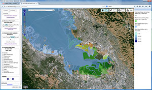
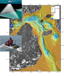
Map of projected flooding (blue shading) at south end of San Francisco Bay under conditions of a 25-centimeter rise in sea level and a 20-year storm. Green-shaded areas are protected by levees but otherwise would be flooded.
High-resolution flood projections for San Francisco Bay shorelines through the 21st century will be available August 2014 on the Our Coast, Our Future website (OCOF, http://data.prbo.org/apps/ocof/). OCOF offers an interactive tool to help Bay Area communities anticipate likely impacts of sea-level rise and climate change. Using results from the USGS Coastal Storm Modeling System (CoSMoS, https://www.usgs.gov/centers/pcmsc/science/coastal-storm-modeling-system-cosmos) in a map-based interface, the online tool allows users to select combinations of storm intensity (average conditions to 100-year storm) and sea-level rise (0 to 5 meters) and observe areas that would flood in response. The Bay Area flood projections are an extension of previous work for the north-central California coast, already available on the OCOF website. Partners include NOAA, the National Park Service, and Point Blue Conservation Science. For more information, contact Patrick Barnard, [email protected], 831-460-7556.
USGS field team successfully maps Fire Island nearshore
 In June, a USGS field team conducted shallow-water bathymetric mapping on Fire Island, New York, using personal watercraft (PWC). The mapping effort was made possible by Hurricane Sandy Supplemental Funding. The field team included personnel from both the Santa Cruz, California and St. Petersburg, Florida Coastal and Marine Science Centers, and they acquired almost twice the amount of data that had been originally been tasked. Members of the team also mapped portions of the flood shoal of the Sandy breach on foot to collect data in water that was too shallow for the PWCs. Coastal and Marine Geology Program staff participating in the data operations included Cheryl Hapke, B.J. Reynolds, Owen Brenner, Dave Thompson, Tim Nelson, Kyle Kelso, Andrew Stevens, Tim Elfers, and Jackson Currie.
Highlights from the latest issue of Sound Waves Newsletter
Coral Reefs Provide Critical Coastal Protection
 New study shows that coral reefs provide risk-reduction benefits to hundreds of millions of coastal inhabitants around the world
“Coral reefs are wonderful natural features that, when healthy, can provide wave-reduction benefits comparable to those of many artificial coastal defenses, and they can adapt to sea-level rise,” said Curt Storlazzi, a coauthor from the USGS. “This research shows that coral reef restoration can be a cost-effective way to decrease the hazards coastal communities face due to the combination of storms and sea-level rise.”
Read the entire article in Sound Waves.
New USGS Coastal and Marine Geology Web Pages Open Doors to Diverse Research Topics, Expertise, and Resources
 We want partners and stakeholders to easily see what we do to support them�to find the tools and products they need. The web is an important resource—our front door. It is important that we share what we are doing and keep it updated so it is current and relevant. These front-end pages are one important piece of our strategy to help the public, agencies at all levels, and a diverse community of researchers find, access, and apply our data and products to their needs and resource management issues.
—USGS Coastal and Marine Geology Program Coordinator, John Haines
Read the entire article in Sound Waves.
Or, go to the Coastal and Marine Geology Program site.
June Center News
Into the Abyss: Living Without Light
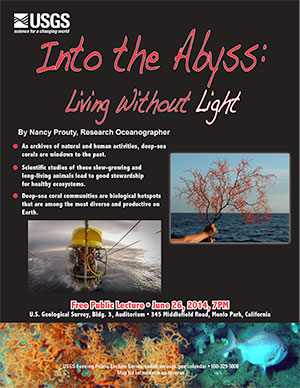 On June 26, Nancy Prouty, USGS Research Oceanographer at the Pacific Coastal and Marine Science Center (Santa Cruz, CA), presented a talk titled, “Into the Abyss: Living Without Light” at the USGS Evening Public Lecture Series at the USGS Menlo Park, CA Campus. Nancy’s talk covered the following points:
- As archives of natural and human activities, deep-sea corals are windows to the past.
- Scientific studies of these slow-growing and long-living animals lead to good stewardship for healthy ecosystems.
- Deep-sea coral communities are biological hotspots that are among the most diverse and productive on Earth.
The video of Nancy's presentation is now archived online, and may be watched online at or downloaded from:
http://online.wr.usgs.gov/calendar/2014/jun14.html
The USGS Evening Public Lecture Series events are usually scheduled for the last Thursday evening of each month. The lectures are free and are intended for a general public audience that may not be familiar with the science being discussed.
The lectures are streamed live online at http://online.wr.usgs.gov/calendar/live.html. Videos of each lecture are archived for viewing anytime at http://online.wr.usgs.gov/calendar/archives.html.
For more information, please visit: http://online.wr.usgs.gov/calendar/. Download the flyer: PDF (230 kb)
USGS Will Explore Caribbean Seamounts
 NOAA’s Office of Exploration and Research has approved a proposal by USGS scientists to explore seamounts off Puerto Rico and the Virgin Islands for two weeks in September 2014. The scientists will sail on the Ocean Exploration Trust’s exploration vessel Nautilus along with colleagues from other agencies and universities. Using the ship and a remotely operated vehicle (ROV), they will acquire multibeam and subbottom data; characterize the seamounts’ geomorphology and geology; describe the abundance, composition, distribution, and food-web ecology of fishes and invertebrate communities, including deep-sea corals; measure water-mass properties, such as temperature, salinity, dissolved oxygen, and currents; and determine habitat specificity of fauna associated with seamount environments. Live video from the ship and ROV will enable some to participate by telepresence. For more information, contact lead-P.I. Amanda Demopoulos, [email protected], 352-264-3490, or (in the Pacific Region) Nancy Prouty, [email protected], 831-460-7526.
USGS-BOEM Workshop Held in Santa Cruz, California
 The USGS Pacific Coastal and Marine Science Center (PCMSC) in Santa Cruz, California, hosted Bureau of Ocean Energy Management (BOEM) officials on May 28, 2014, for a USGS-BOEM roundtable on research needs, project updates, and future directions. Participants discussed ways to strengthen working relationships between USGS and BOEM, improve understanding of each agency’s science capabilities and planning and funding processes, and identify mutual scientific needs and goals. The day ended with posters highlighting BOEM-funded scientific work. USGS participants came from the PCMSC; Western Ecological Research Center; Alaska Science Center; Forest and Rangeland Ecosystem Science Center; Pacific Islands Ecosystems Research Center; California Water Science Center; Oregon Water Science Center; National Research Program; the Pacific, Northwest, and Alaska regional offices; Western Fisheries Research Center; and the Environments Program of the Ecosystems Mission Area. For more information, contact Bob Rosenbauer, [email protected], (831) 460-7401.
Highlights from the April/May Issue of Sound Waves
Assessing the Vulnerability of Pacific Atolls to Climate Change
 by Peter Swarzenski
The USGS is leading a multi-agency project to assess the impacts of sea-level rise and storm-wave inundation on small Pacific atoll islets and their freshwater resources. Read more...
New Kid on the Web: USGS Coastal and Marine Geology Program's Redesigned Website Goes Live
 On March 11, 2014, the U.S. Geological Survey (USGS) Coastal and Marine Geology Program launched its newly designed website. The site features dynamic new "front end" webpages that highlight the Program's research and expertise as they pertain to specific coastal and marine issues facing our Nation. Watch for a related article in the next issue of Sound Waves, and please visit the new site: http://marine.usgs.gov
May Center News
 Sanctuary Celebration on the Santa Cruz Wharf
The USGS will participate in a celebration of the Monterey Bay National Marine Sanctuary on May 17, 2014, on the municipal wharf in Santa Cruz, California. The family-oriented event, which runs from 11 a.m. to 5 p.m., will include live music, arts and crafts, and educational activities. The USGS Pacific Coastal and Marine Science Center will host a booth where visitors can create water currents in a tank and measure them with a current meter; observe foraminifera (single-celled marine organisms) through microscopes and learn how they are used to date seafloor sediments and study climate change; and view a short movie featuring USGS seafloor video, bathymetric data, and rare observations of submarine turbidity currents in Monterey Canyon. The festival is part of a year-long celebration of the 100th anniversary of the Santa Cruz Wharf. For more information, contact Helen Gibbons, [email protected], 831-460-7418.
Briefing for U.S. Ambassador in Republic of the Marshall Islands on Sea-Level Rise and Climate Change Impacts on Pacific Island Atolls
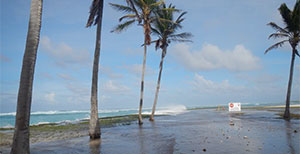
 USGS research geologist Curt Storlazzi will brief Ambassador Armbruster and his staff at the U.S. Embassy on Majuro in the Republic of the Marshall Islands (RMI) on May 8–9, 2014. Storlazzi will explain the project he leads, “The Impact of Sea-Level Rise and Climate Change on Department of Defense Installations on Atolls in the Pacific Ocean,” as well as other USGS efforts to understand climate-change and sea-level-rise impacts on atolls. RMI consists mainly of low-lying atolls already threatened by sea-level rise and changing climate. In March 2014, a combination of unusually high tides and waves flooded the capital for the third time in a year and led RMI’s president to declare a state of emergency. For more information, contact Curt Storlazzi, [email protected], 831-460-7521.
Continued Investigation of Sea-Level-Rise and Climate-Change Impacts on Pacific Ocean Atolls
 USGS scientists from the Pacific Coastal and Marine Science Center will conduct fieldwork on Kwajalein Atoll in the Republic of the Marshall Islands with collaborators from the National Oceanic and Atmospheric Administration (NOAA) April 20–May 7, 2014. Scientists from NOAA’s National Centers for Coastal Ocean Science (NCCOS) and Center for Coastal Fisheries and Habitat Research (CCFHR) will join the USGS researchers to gather data on bathymetry, topography, tides, waves, run-up, and the resulting wave-driven inundation of the atoll islands. The work is part of a project funded by the Department of Defense (DoD) to assess the impacts of sea-level rise and climate change on Pacific atolls that house DoD installations. The findings will also be useful to Pacific island nations already threatened by sea-level rise and changing climate. For more information, contact Curt Storlazzi, [email protected], 831-460-7521.
April Center News
USGS and Skagit Climate Science Consortium Provide Outreach on Western Washington Coastal Climate Change
 On April 24, USGS scientists and members of the Skagit Climate Science Consortium held an Open House in Mt. Vernon, WA, on climate change impacts to Western Washington and the Skagit River Watershed. Federal, tribal, state, county and municipal elected officials, public works staff and planners, and community members attended. Presentations and a poster forum updated projections on how climate change will impact coastal communities, agriculture, infrastructure, ecosystems, and restoration goals for salmon recovery. This information will help the region's communities, planners, and the US Army Corps of Engineers (USACE) understand how flood hazards from rivers and sea-level rise are likely to influence the USACE Skagit General Flood Investigation and preferred alternatives for Skagit River Flood Hazard Mitigation. For more information and copies of the presentations visit http://www.skagitclimatescience.org/ or contact Eric Grossman, [email protected], 831-234-4674.
Congressman Sam Farr Drops by USGS Pacific Coastal and Marine Science Center in Santa Cruz, California; Recognizes LEED Certification of Building
Left to right: William Ow (Ow Properties), Bob Rosenbauer (USGS Pacific Coastal and Marine Science Center Director), Jane Reid (Deputy Center Director), and Congressman Sam Farr hold plaque and letter commemorating LEED Gold Award given to the USGS center in 2013.
Congressman Sam Farr (D-CA, 20th District) visited the USGS office on April 24. Farr was in Santa Cruz for the opening of his show of personal photographs at the R. Blitzer Gallery, the same gallery where the USGS Earth-Science-Art exhibit was shown in 2012. The USGS office and gallery are housed in the same building, owned by Ow Properties. William Ow took the opportunity to bring Farr, Donna Blitzer (Director of Government Relations, University of California, Santa Cruz), and Carina Chavez (with Farr's local office) to the USGS so they could be present when Ow shared framed acknowledgements of the building's LEED Gold Award (http://www.usgbc.org/leed) with USGS Science Center leaders.
The LEED award is on display in the USGS office. For more information, contact Jane Reid, [email protected], 831-460-7402.
March Center News
USGS a Key Contributor to Tsunami Preparedness Exercises
 As part of National Tsunami Preparedness Week, March 23 to 29, the San Francisco [California] Department of Emergency Management is conducting a 3-day functional exercise to practice the city�s tsunami alert and warning procedures, response capabilities, and recovery operations. USGS marine geophysicist Stephanie Ross is representing the USGS at this exercise, which is based on the SAFRR Tsunami Scenario developed by USGS scientists and collaborators and released September 2013. NOAA's annual PACIFEX tsunami-warning exercise on March 27 is also based on the SAFRR Tsunami Scenario. Some of the organizations and communities holding PACIFEX-related exercises include Washington State and California's San Mateo, Marin, and Orange Counties. The National Institutes of Health will hold a recovery-phase exercise on April 7. For more information, contact Stephanie Ross, [email protected], 650-329-5326.
USGS Participates in Public Tsunami Preparedness Walks
 As part of National Tsunami Preparedness Week, March 23 to 29, many coastal communities are holding Tsunami Walks, starting at the coast and walking uphill out of the expected inundation zone. Stephanie Ross, USGS marine geophysicist and coordinator of the SAFRR Tsunami Scenario, will represent the USGS at the San Francisco Tsunami Walk on Saturday, March 29, which begins at 10:30 a.m. on the Marina Green (at Marina and Scott). During this free public event (see event web page), participants will simulate an actual tsunami evacuation, walking away from San Francisco Bay toward higher ground (the Marina Branch Library at Chestnut and Webster). In California, other tsunami walks are being held in Crescent City, Muir Beach, Huntington Beach, Seal Beach, and San Diego. For more information, contact Stephanie Ross, [email protected], 650-329-5326.
USGS Paleontologists Will Participate in “BioBlitz” Species Inventory
 USGS paleontologists Mary McGann and Scott Starratt will participate in an all-taxa species inventory on March 28–29, 2014, in California’s Golden Gate National Recreation Area. During the “BioBlitz”—sponsored by the National Geographic Society and the National Park Service—teams of volunteers led by expert scientists will find and identify as many species as possible within a 24-hour period. McGann (Pacific Coastal and Marine Science Center) and Starratt (Volcano Hazards Program) will sift through San Francisco Bay-floor sediment to identify foraminifera (McGann) and diatoms (Starratt), one-celled organisms that make shells of calcium carbonate and silica, respectively. These shells can provide information about present ecosystem health and past climate and oceanographic conditions. One BioBlitz goal is to create broader impacts through public outreach, science education, and media coverage of this scientific endeavor. For more information, contact Mary McGann, [email protected], 650-329-4979.
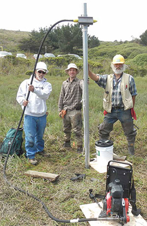
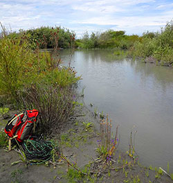
Studying Marsh Sediment and Drought in San Francisco Bay
 Jessie Lacy and five other scientists from the USGS Pacific Coastal and Marine Science Center completed fieldwork to measure sediment delivery to marshes near China Camp State Park on San Pablo Bay, the northern extension of San Francisco Bay. From February 25–28, they recovered instruments that measured variations in suspended-sediment concentration in time and space, as well as current speed and direction, to determine transport of sediment. Because of the California drought emergency, they redeployed three instruments for longer term monitoring of salinity and suspended-sediment concentrations in San Pablo Bay. Results of the marsh studies will be used to improve models of marsh response to sea-level rise. The redeployed instruments will measure conditions during this serious drought, which could increase salinity and decrease suspended-sediment concentrations, owing to reduced freshwater flows. For more information contact Jessie Lacy, [email protected], 831-460-7520.
USGS research geophysicist contacted about tsunami potential of the Cascadia Subduction Zone
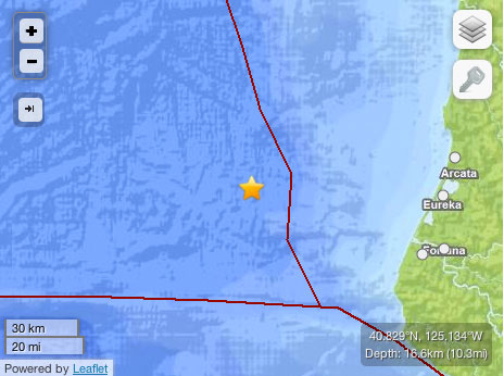 Eric Geist was contacted regarding how tsunamis generated by the Cascadia Subduction Zone (off northern California, Oregon, Washington, and British Columbia) could affect the U.S. west coast. The questions followed a magnitude-6.8 earthquake that occurred offshore of northern California on March 9, 2014 (local time). The earthquake occurred in the Gorda subplate, a tectonic plate that is subducting beneath the Pacific Northwest at a rate of about 23 millimeters/year. Los Angeles Times staff writer Rong-Gong �Ron� Lin II interviewed Geist, and KTVU meteorologist Mark Tamayo contacted him for information (no interview). For more information, contact Eric Geist, [email protected], 650-329-5457.
USGS scientist provides tsunami animations for public broadcasting stories on Oregon earthquake and tsunami threats
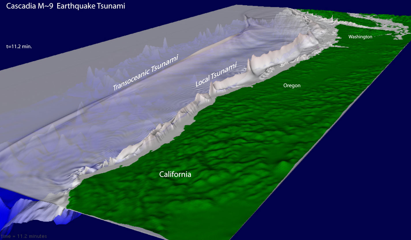 Eric Geist was contacted by Ed Jahn, reporter and producer of Oregon Public Broadcasting’s OPB NEWS/Oregon Field Guide, for animations of a hypothetical tsunami triggered by a magnitude-9 earthquake in the Cascadia Subduction Zone (off northern California, Oregon, Washington, and British Columbia). Jahn saw Geist’s original tsunami animations in an Oregon Department of Geology and Mineral Industries (DOGAMI) educational video. Geist revised the animations for Jahn, who will use them in several stories on the Cascadia Subduction Zone earthquake and tsunami threat to Oregon. For more information, contact Eric Geist, [email protected], 650-329-5457. [See larger version of graphic.]
Jan/Feb Issue of Sound Waves Highlights
Deep-Sea Corals Record Human Impact on Watershed Quality in the Mississippi River Basin
USGS Scientist Examines Foraminifera Collected from Remote Clipperton Island
Deepwater Canyon Study Among Projects Given Prestigious DOI Partners in Conservation Award
February Center News
Effects of dam removal on coastal and marine ecosystems
 USGS ecologist and Mendenhall post-doc Melissa Foley continues to study how the removal of two dams on the Elwha River in Washington state is affecting coastal and marine ecosystems. Foley is working with biologists for the Lower Elwha Klallam Tribe to understand how changes in physical factors such as salinity, temperature, and turbidity affect biological productivity in estuaries near the river mouth, which have historically served as nursery habitat for juvenile salmon. In the nearshore, Foley is working with other USGS scientists to identify factors causing the loss of subtidal algae around the mouth of the Elwha River. Foley is measuring light availability, sediment deposition, and scouring frequency to determine if one or a combination of these factors is driving the marked decrease in algal cover since dam removal began in 2011. For more information, contact Melissa Foley, [email protected], or 831-460-7564. Visit the "USGS Science to Support the Elwha River Restoration Project" web site.
USGS Scientists Map Snohomish Delta, Washington
 To inform managers tasked with ecosystem restoration, salmon recovery, flood-hazard mitigation, and climate-change planning in Puget Sound, scientists from the Pacific Coastal and Marine Science Center are mapping the Snohomish Delta where data either do not exist or were last collected in the 1960s. Swath bathymetry and acoustic backscatter data will be merged with recent LiDAR data to generate high-resolution (1-meter) onshore-offshore digital-elevation and substrate models to characterize important salmon habitats, sediment budgets, and transport processes, and the effects of artificial levees. Many Pacific Northwest river-delta wetlands have lost habitat due to levees that focus stream flow and sediment offshore, leaving wetlands starved for sediment and vulnerable to sea-level rise while fragmenting nearshore seagrass meadows—both essential habitats for endangered salmon species. The data will provide important boundary conditions for hydrodynamic modeling. For more information, contact Eric Grossman, [email protected], 206-526-2529.
Groundwater Studies on Kwajalein Atoll
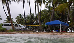 Peter Swarzenski of the USGS Pacific Coastal and Marine Science Center will continue studies of the coastal aquifer of Roi Namur Island, Kwajalein Atoll, February 23–March 3, 2014. Swarzenski is investigating underground freshwater and saltwater using geochemical and geophysical techniques, including trace metal, nutrient, and carbon geochemistry; radon isotope analysis; piezometry; thermal conductivity; and electrical resistivity. This work is part of a joint study for the Department of Defense, Strategic Environmental Research and Development Program (SERDP) by USGS, NOAA, and the University of Hawaii, to assess impacts of sea-level rise and storm-wave inundation on infrastructure and freshwater under various sea-level rise and climate scenarios. DOD will use the findings to develop climate-change adaptation plans for infrastructure and water resources. The findings also will be useful to Pacific island nations threatened by sea-level rise and climate change. For more information contact Peter Swarzenski, [email protected], 831-460-7529.
Nov/Dec Issue of Sound Waves Highlights
Natural Versus Human Impacts on Marine Ecosystems in Hood Canal
Special Issue of Marine Geology Focuses on San Francisco Bay Coastal System
Michael E. Field Honored by U.S. Coral Reef Task Force
January Center News
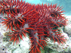 Threats to Coral Reefs in American Samoa
USGS geologist Curt Storlazzi traveled to the National Park of American Samoa in mid-January 2014 to help the National Park Service address threats to coral reefs on the north side of the island of Tutuila. Threats include pollution caused by historical land-use practices, climate change (coral bleaching has occurred), outbreaks of crown-of-thorns sea stars (pictured here) that can kill coral reefs, and overfishing of grazers that suppress algal overgrowth caused by land-based pollution. Storlazzi also coordinated with academic, NOAA, and EPA scientists and American Samoa officials on research needs for the US Coral Reef Task Force priority study area at Faga'alu on the south side of Tutuila, where excessive land-based pollution threatens reefs. For more information, contact Curt Storlazzi, [email protected], 831-460-7521.
USGS Among Recipients of Prestigious DOI Partners in Conservation Award
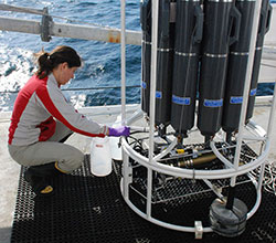 The multiagency project “Bureau of Ocean Energy Management (BOEM) Atlantic Deepwater Canyons” is a recipient of the 2013 U.S. Department of the Interior’s Partners in Conservation Award. This study investigated the ecology of deepwater canyons off the U.S. mid-Atlantic coast—pathways for nutrients, sediments, and pollutants from the continental shelf to the deep sea about which little was previously known. Participants came from 17 organizations, including USGS, BOEM, NOAA, WHOI, several universities, private firms, and the North Carolina Museum of Natural Science. Principal USGS participants are Colleen Charles, Amanda Demopoulos, Cheryl Morrison, Christina Kellogg, and Nancy Prouty. Out of many nominations, only 20 partnerships were recognized in 2013 from all nine bureaus of DOI. The Secretary of the Interior presented the awards January 16, 2014, in Washington, D.C. For more information, contact Nancy Prouty, [email protected], 831-460-7526.