
Woods Hole Science Center
![]() Title |
Introduction |
Setting |
Methods |
Overview |
Interpretation |
Discussion |
Data Catalog |
Acknowledgments |
References |
Figures |
Bottom Photographs |
Sediment Data |
Contacts
Title |
Introduction |
Setting |
Methods |
Overview |
Interpretation |
Discussion |
Data Catalog |
Acknowledgments |
References |
Figures |
Bottom Photographs |
Sediment Data |
Contacts
 |
||
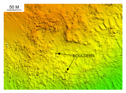
Figure 23. Detailed planar view of the bouldery sea floor south of Fox Point on Nashawena Island from the DTM produced during NOAA survey H11076. These boulders are associated with outcrops of glacial drift, and are probably lag deposits of the till that is exposed onshore in the Buzzards Bay moraine. Location of view is shown in figure 22. | ||


