Woods Hole Science Center
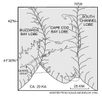
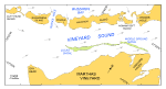
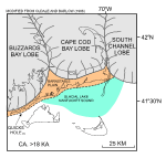
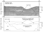
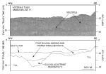
The geology of Cape Cod and the adjacent islands is a product of glacial processes, which occurred during the late Pleistocene, and a storm and tidally dominated marine regime during the Holocene sea-level rise. The late Wisconsinian Laurentide ice sheet reached its maximum extent and southernmost position about 20 ka, as marked by terminal moraines on Block Island, Martha's Vineyard, and Nantucket and the southern limit of abundant gravel on the intervening sea floor (Schlee and Pratt, 1970; Oldale, 2001; Uchupi and others, 1996; fig. 2). This lobate ice front was formed by the Buzzards Bay lobe that deposited the moraine along the western part of Martha's Vineyard, the Cape Cod Bay lobe that deposited the moraines across eastern Martha's Vineyard and Nantucket, and the South Channel lobe that extended east toward Georges Bank (Oldale and Barlow, 1986; Oldale, 2001). A series of recessional moraines lie north of the terminal moraine on Martha's Vineyard. One of these recessional moraines, the Lucas moraine, occupies a position along the axis of Vineyard Sound marked by Lucas and Middle Ground Shoals (Smith, 1969; fig. 3). Shortly prior to 18 ka, the ice sheet had retreated and the Buzzards Bay lobe occupied a position along the Elizabeth Islands, the Cape Cod Bay lobe a position along the northern edge of Cape Cod, and the Great South Channel lobe to just north of Great South Channel (Larson, 1982; Uchupi and others, 1996; Balco and others, 2002; fig. 4). The concave-northward arc of the Elizabeth Islands mimics the moraine along the eastern side of Buzzards Bay, and records a re-advance or pause in this lobe's retreat (Oldale, 2001). Also about this time, the main part of Cape Cod was deposited as the Barnstable outwash plain and a glacial lake occupied Nantucket Sound. The rate of the lobes' retreat varied. Deposits associated with the Buzzards Bay lobe are oldest; deposits associated with the Great South Channel lobe are youngest (Oldale and O'Hara, 1984; Oldale, 2001). Just after 18 ka, continued retreat of the ice fronts positioned the Buzzards Bay lobe northwest of Buzzards Bay, the Cape Cod Bay lobe in the center of Cape Cod Bay, and the Great South Channel lobe northward and eastward (Uchupi and others, 1996). Shallow stratigraphy interpreted from high-resolution seismic profiles, collected as part of earlier studies (Robb and Oldale, 1977; O'Hara and Oldale, 1980), reflects this Quaternary history (fig. 5 and fig. 6). Deposits of till have an irregular, abrupt upper surface and form acoustic basement; layered, rhythmic, relatively flat lying glaciolacustrine deposits fill low spots on the surface of the till; and in areas where deposition has occurred, transitional and postglacial marine deposits are draped over the underlying units. The Holocene marine transgression submerged much of the offshore extension of the Buzzards Bay moraine. Topographic highs along this part of the moraine form the Elizabeth Islands, a 26-km long chain of small islands that trends southwest from Cape Cod and that effectively separates Vineyard Sound from Buzzards Bay (fig. 3). Passages between the islands are provincially called "holes." Quicks Hole, the only navigable gap within the southwestern part of the chain for vessels with drafts greater than 3 m, is the passage between Nashawena and Pasque Islands. Strong tidal currents in the holes are driven by the different filing rates and sizes of the adjacent water bodies. Flood tide in Quicks Hole, which flows south from Buzzards Bay into Vineyard Sound, exceeds 2.7 kts (fig. 3). Ebb tides are weaker, but exceed 2.4 kts. These currents have winnowed the till that composes the moraine, locally leaving bouldery lag deposits on the sea floor. |
Click on figures for larger images.
|
![]() Title |
Introduction |
Setting |
Methods |
Overview |
Interpretation |
Discussion |
Data Catalog |
Acknowledgments |
References |
Figures |
Bottom Photographs |
Sediment Data |
Contacts
Title |
Introduction |
Setting |
Methods |
Overview |
Interpretation |
Discussion |
Data Catalog |
Acknowledgments |
References |
Figures |
Bottom Photographs |
Sediment Data |
Contacts