
Woods Hole Science Center
![]() Title |
Introduction |
Setting |
Methods |
Overview |
Interpretation |
Discussion |
Data Catalog |
Acknowledgments |
References |
Figures |
Bottom Photographs |
Sediment Data |
Contacts
Title |
Introduction |
Setting |
Methods |
Overview |
Interpretation |
Discussion |
Data Catalog |
Acknowledgments |
References |
Figures |
Bottom Photographs |
Sediment Data |
Contacts
 |
||
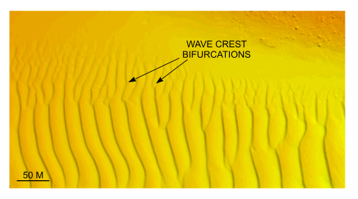
Figure 33. Detailed planar view of the bedforms south of Pasque Island from the DTM produced during NOAA survey H11076. Note that crest-line bifurcations are most common along the edge of a sand wave field. Location of view is shown in figure 22. | ||


