
Woods Hole Science Center
![]() Title |
Introduction |
Setting |
Methods |
Overview |
Interpretation |
Discussion |
Data Catalog |
Acknowledgments |
References |
Figures |
Bottom Photographs |
Sediment Data |
Contacts
Title |
Introduction |
Setting |
Methods |
Overview |
Interpretation |
Discussion |
Data Catalog |
Acknowledgments |
References |
Figures |
Bottom Photographs |
Sediment Data |
Contacts
 |
||
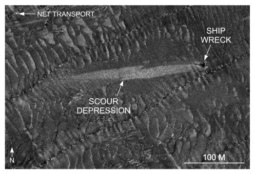
Figure 44. Detailed planar view of a scour depression associated with a shipwreck south of Pasque Island from the sidescan sonar mosaic produced during NOAA survey H11076. High backscatter in the scour depression shows that coarser grained sediment is present there; scour asymmetry indicates that net transport is to the west. Location of view is shown in figure 22. | ||


