USGS PCMSC

Geotechnical and Surface Wave Investigation of the Great M 7.9
Denali Fault Earthquake of 3 November 2002

Index Back to Home PageAbout these Web PagesGeneral ObservationsAcknowledgmentsSASW-Site Characterization of Pump Stations 9, 10, and 11Earthquake Effects on the Trans-Alaska PipelineLiquefaction Damage at Northway AirportIndex Map 2Surface Wave TestingSpacial CharacterLiquefaction and Ground DisplacementIndex Map 1Abstract

Liquefaction Damage to the Tarmac at Northway Airport

Lateral spreading at Northway Airport. Large sand vents and sink holes at the Nortway Airport.
Sand boils at Northway weather station. LIne drawing of polygon-shaped lateral spreads.

Click on image to view larger version  

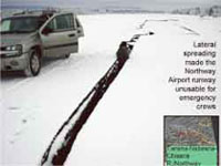
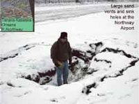
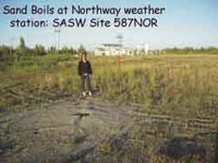
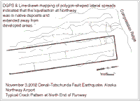
The airport at Northway was rendered unusable by lateral spreading. The frozen surface layer and pavement runway were cut by fissures, many 10-30 cm wide, some more than a meter wide. On the perimeter of the runway were large sand vents and sink holes up to 4 m in diameter and up to 1 m deep. Reports from residents describe pressurized ground water spewing out soil 2-4 m into the air. Parallel and polygon patterns similar to those observed in the Tanana River bars were observed at Northway. Away from the runway, houses and structures were unseated and tilted on their foundations, and road settlements bent and crushed drainage culverts.


Abstract | Index Map 1 | Liquefaction and Ground Displacement | Spacial Character | Surface Wave Testing
Index Map 2 | Liquefaction Damage at Northway Airport | Earthquake Effects on the Trans-Alaska Pipeline
SASW-Site Characterization of Pump Stations 9,10 &11 | Acknowledgments | General Observations | About These Web Pages
Geotech Home Page


 Previous page, Part 1, Surface Wave Testing  Title Page  Next page, Earthquake Effects on the Trans-Alaska Pipeline  Return to Geotech Home Page  USGS Pacific Coastal and Marine Science Center


geotech/denaligeoposter/damage.html
CONTACT: Robert Kayen
last modified 2018