|
Liquefaction & Ground Displacement
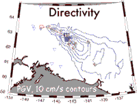
Liquefaction and lifeline damage was widespread throughout eastern central-Alaska, and its pattern of increase severity and spatial extent towards the east end of the rupture zone suggests that directivity effects amplified motions towards the east. This is due to the apparent focusing of seismic waves toward the eastern end of the unidirectional 320 km rupture. Field observations are consistent with kinematic rupture modeling (Dreger et al., 2004) that predicts an expanding cone of shaking intensity (velocity contours, PGV) toward the east. |
|||||||||||
|
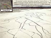
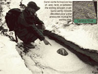
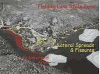
On the north side of the Alaska range in the Tanana River valley, extensive liquefaction was observed where very young river deposits were capped by a thin (<0.3m) frozen surface layer at source distances of 50 to 120 km. Tanana River valley liquefaction was widespread from Fairbanks to the west, to at least Northway, several hundred km eastward. In the Tok-Northway region nearly every river bar deposit appear to have failed. In total, Tanana River bar failures covered a vast area. The Nabesna River had an asymmetrical pattern of liquefaction about the fault crossing, with the southern liquefaction area limited to about 5 km from the fault, but the (downstream) liquefacton area to the north extending all the way to Northway. Liquefaction and lateral spreading was observed near the Delta River headwaters at Fielding Lake, and more limited liquefaction was observed on Delta River alluvium immediately south of the fault crossing. No liquefaction was observed north of the fault on the Delta River. Liquefaction on these glacial rivers, thus, was controlled by sedimentation patterns, tectonics (ponding of sediment, steepness of terrain) and the asymmetric and directivity-driven pattern of earthquake shaking intensity. |
||||||||||||
|
|
||||||||||||
geotech/denaligeoposter/liquefaction.html
CONTACT: Robert Kayen
last modified 2018