USGS PCMSC

Geotechnical and Surface Wave Investigation of the Great M 7.9
Denali Fault Earthquake of 3 November 2002

Index Back to Home PageAbout these Web PagesGeneral ObservationsAcknowledgmentsSASW-Site Characterization of Pump Stations 9, 10, and 11Earthquake Effects on the Trans-Alaska PipelineLiquefaction Damage at Northway AirportIndex Map 2Surface Wave TestingSpacial CharacterLiquefaction and Ground DisplacementIndex Map 1Abstract

Spacial Character of Liquefaction in Glacial River Systems

Bringing SASW into the Nabesna River back country.
 
Hiking SASW gear up-river to site 581-NAB.
 
585NAB: Non-Liquefaction Site - hammer source for remote sites.
 

Geotechnical field investigations: We used a helicopter and a portable SASW unit with hammer source to test 5 Nabesna River sites south of the fault rupture. On the Delta river we drive to test sites and used a harmonic wave source. On the Nabesna river liquefaction ground failure abruptly ends south of test site 581NAB, but continues north all the way to the Tanana lowland at Northway ~60 km away. On the Delta River, liquefaction occurs in pockets of fault-ponded alluvium and isolated spots of low-energy deposition.
 

Delta River

 
591DEL: Non Liquefaction Site, shaker source for vehicle accessible sites.
 
592DEL: Non-Liquefaction Site.
 
597, 598, 599FLD: Liquefaction and uplift.
 
596DEL: Liquefaction and fissures.
 

Nabesna River Testing

Delta River Testing

 
Location map and plots of Nabesna River Testing.
 
 
Location map and plots of Delta River Testing.
 
Click on illustration to view larger version
 

Shear wave profiles for 9 sites on the Nabesna and Delta Rivers: Mean grain size and shear wave velocity both fall down-stream (northward) from the Nabesna glacier. On the south side of the fault rupture (nearer to the glacier), the shear wave profiles progressively decrease in velocity toward the fault. Low shear wave velocities in sand and gravel (red zone) indicate potentially liquefiable near-surface strata. On the Delta River, numerous side-entering glacial valleys bring in prodigious loads of coarse material into the mainstem river. Liquefaction observations only occur in areas where ponded sediment is found upstream of (1) major glacial alluvium inputs or (2) the Denali fault.

Click on illustration to view larger version
 

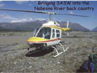
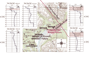
Asymmetry of the Nabesna River ground failures on either side of the fault rupture are the result of steady northward decline in liquefaction resistance intersecting a fault-normal symmetrical (?) ground motion intensity field. Transition from non-liquefied to fully liquefied zones occurred abruptly along a narrow swath on the south side, with no such transition occurring on the north side.


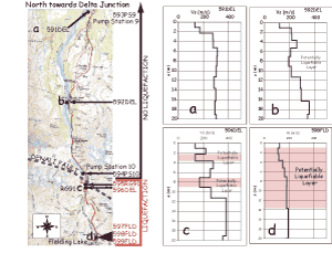
Delta river liquefaction features are more complex than for the Nabesna. Termination of liquefaction ground failure zones are the result of enormous glacier river inputs of poorly sorted cobble-sand at and below Canwell Glacier. At the fault crossing abundant sand boils are seen along the fault scarp. Fielding and summit lakes are quiet depositional areas of silty sand off Phelan creek.


Abstract | Index Map 1 | Liquefaction and Ground Displacement | Spacial Character | Surface Wave Testing
Index Map 2 | Liquefaction Damage at Northway Airport | Earthquake Effects on the Trans-Alaska Pipeline
SASW-Site Characterization of Pump Stations 9,10 &11 | Acknowledgments | General Observations | About These Web Pages
Geotech Home Page


 Previous page, Liquefaction and Ground Displacement  Title Page  Next page, Surface Wave Testing  Return to Geotech Home Page  USGS Pacific Coastal and Marine Science Center


geotech/denaligeoposter/spacial.html
CONTACT: Robert Kayen
last modified 2018