|
Study Area |
|
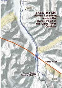
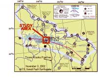
Our survey across the Denali fault along the TAPS/Delta River corridor. Surface break occurred along the entire 320 km rupture. At the Delta River crossing of the Denali Fault the surface rupture was ~5.5m right lateral and 0.6-0.8m up to the north. An overview of the severity of Geotechnical damages are plotted on the right along major drainages of the Alaska Range.
|
|
|
Poster Home Page | Abstract | Study Area | SASW Method & Results | LIDAR & Radar | Summary | About These Web Pages |
|
geotech/denliposter/area.html
contact: Robert Kayen
last modified 2018