The 26 December 2004 Indian Ocean Tsunami: Initial Findings from Sumatra
Inundation
Inundation distances in the province were so large that they were most easily measured from satellite images, where sediment deposited by the waves and vegetation killed by the saltwater are clearly visible. One such image (below) shows that the waves that struck the villages of Lampuuk and Lho Nga on the west coast met the waves that struck Banda Aceh from the north.
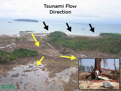
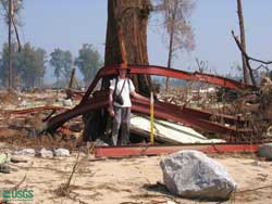
Items broken and bent by the tsunami waves were used to determine flow directions. The scientists found that the large tsunami waves flowed around natural barriers, flooding low-lying areas behind them.
 Brown tones of tsunami deposits and vegetation killed by saltwater show the extent of the tsunami's inundation (indicated by line) in this satellite image of northwestern Aceh province. Arrows indicate tsunami flow directions. Note that tsunami waves flowing in from the north met waves from the west in one area. Satellite image acquired using Space Imaging's IKONOS satellite and processed by the Centre for Remote Imaging, Sensing and Processing (CRISP), National University of Singapore. [larger version] |
 Above, black arrows indicate tsunami flow direction as the waves hit the shore; then, where the waves were forced inland past barriers, the flow became focussed and wrapped around in back of these barriers. [larger version] Below, ITST member Raphael Paris stands near steel beams wrapped around tree in Lho Nga. [larger version]  |
 |
 |
 |
 |

 Damage to structures