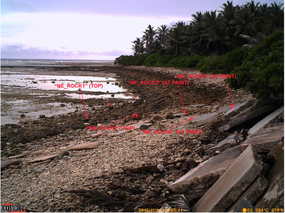
Time-lapse camera systems were deployed to correlate offshore and reef-flat wave and tide data to wave-driven water levels up the shoreface. Targets (labeled in this photo with red arrows) in the cameras’ field of view were tied into DGPS in order to acquire quantitative (elevation and landward extent) information on run-up from the digital time-lapse imagery.
The Community Climate System Model (CCSM) was created by the National Center for Atmospheric Research (NCAR). CCSM4 is an atmosphere-ocean coupled global climate model for simulating Earth's climate system.
CCSM4 Web Site: http://www.cesm.ucar.edu/models/ccsm4.0/.
Under the World Climate Research Programme (WCRP), the Working Group on Coupled Modelling (WGCM) established the Coupled Model Intercomparison Project (CMIP) as a standard experimental protocol for studying the output of atmosphere-ocean coupled general circulation models. The CMIP is now in its 5th phase of study (e.g., CMIP5), and it is being developed concurrently with the Intergovernmental Panel on Climate Change's Fifth Assessment Report (IPCC-AR5).
CMIP Web Site: http://cmip-pcmdi.llnl.gov
CMIP5 Web Page: http://cmip-pcmdi.llnl.gov/cmip5/
A digital elevation model (DEM) is a digital geographic dataset of elevations in xyz coordinates. Ground elevations are sampled at regularly spaced horizontal intervals.
Differential Global Positioning System (DGPS) is an enhancement to Global Positioning System (GPS) that provides improved location accuracy. DGPS uses a network of fixed, ground-based reference stations to broadcast the difference between the positions indicated by GPS satellite systems and the known positions of the referenced stations.
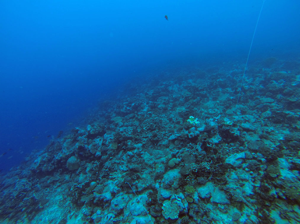
This instrument measures wave height, wave direction, current speed, and current direction. The instrument has been installed on the fore reef of Roi-Namur Island.
The European Center for Medium-range Weather Forecasting-Interim is a global atmospheric reanalysis from 1979, continuously updated in real time.
ECMWF Web Site: http://www.ecmwf.int/en
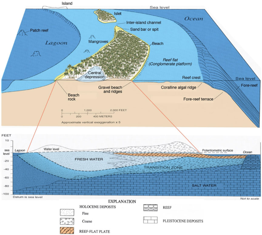
The fore reef (also called the reef slope) is found at the outer edge of the fringing reef, closest to the open ocean. This area of the reef is often quite steep and descends either to a relatively shallow sand bottom or to depths too great to allow coral growth.
Definition from Castro, Peter and Huber, Michael E. 2008. Marine Biology. 7ed. McGraw-Hill, New York.
Figure from Fletcher and Richmond, 2010.
A freshwater lens is a convex layer of fresh groundwater that floats on top of denser seawater. The lens develops and is recharged from rainwater. Freshwater lenses are often found on small coral or limestone islands and atolls and may be the only natural source of potable water.
Figure from Fletcher and Richmond, 2010.
Global climate models (GCMs) are also known as general circulation models, and are a class of computer-driven models for weather forecasting, understanding the climate, and predicting climate change.
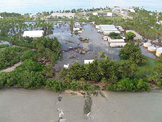
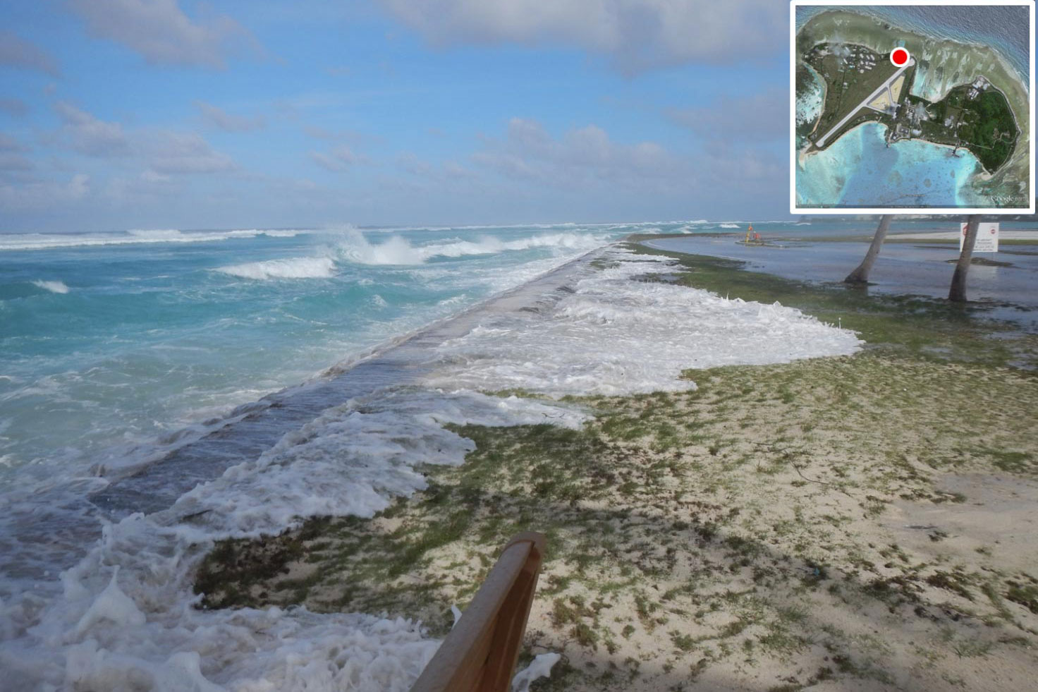
Inundation is the flooding of normally dry, low-lying land, primarily caused by severe weather events. On low-elevation islands like those of Kwajalein Atoll, sea-level rise and climate change may further increase the risk of seawater inundation from wave run-up and storm surge, which threatens freshwater sources and infrastructure.
See also, National Oceanic and Atmospheric Administration's (NOAA) "Understanding Coastal Inundation".
Photo courtesy of Department of Defense, U.S. Army Kwajalein Atoll (DoD USAKA).
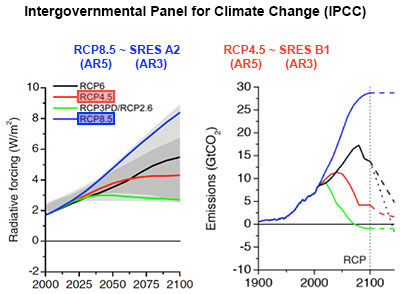
Intergovernmental Panel on Climate Change's Fifth Assessment Report "provides a clear and up to date view of the current state of scientific knowledge relevant to climate change", and includes four representative concentration pathways (RCPs).
IPCC Web Site: http://www.ipcc.ch
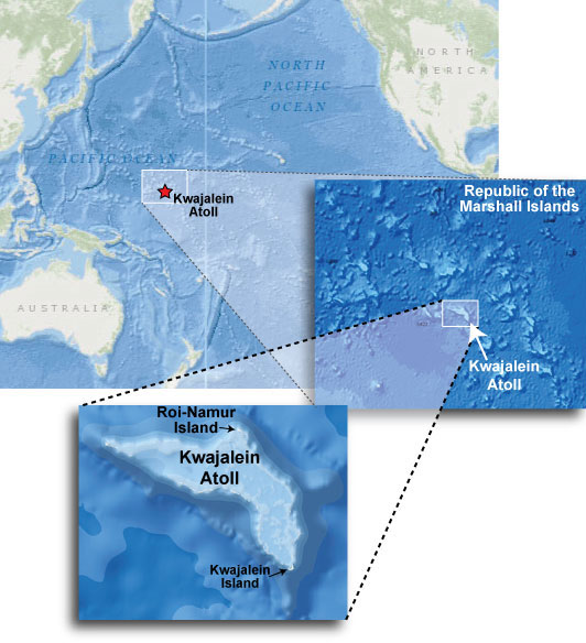
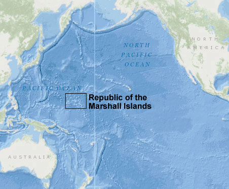
Kwajalein Atoll is part of the Republic of the Marshall Islands (RMI) in the northern Pacific Ocean. Kwajalein is the world's largest coral atoll surrounding the world's largest lagoon. Kwajalein Atoll is part of the U.S. Army Ronald Reagan Ballistic Missile Defense Test Site (or "Reagan Test Site"), a missile test range in the Pacific Ocean.
Kwajalein is a large (maximum width ~100 kilometers) atoll system with a large, deep lagoon and large islets that support freshwater lenses.
Kwajalein Island is the southernmost, largest island in the atoll. The northernmost, second largest island is Roi-Namur, where this study is focused.
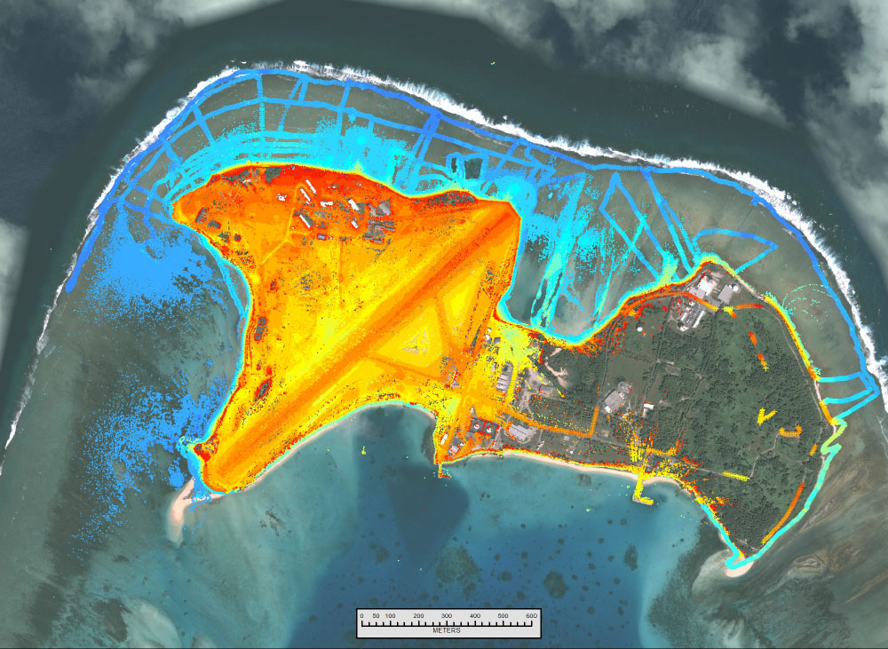
Lidar is a remote sensing technology that measures distance by illuminating a target with a laser and analyzing the reflected light. In this study, a ground-based, or terrestrial, lidar system is used for close-range, high-resolution mapping, accurate to the sub-centimeter scale.
At right, an individual lidar scan on Roi-Namur Island, Kwajalein Atoll, shows the high-resolution point cloud of data generated by the sensor that can clearly map palm trees and their individual palm fronts, which are on the order of just a few centimeters across.
Model for Interdisciplinary Research on Climate: MIROC5 is version 5 of the atmosphere-ocean coupled general circulation model developed at the Center for Climate Systems Research, Toyko.
NOAA's third generation global wave model, which runs four times a day (00Z, 06Z, 12Z, and 18Z). Each run starts with 9-, 6- and 3-hour hindcasts and produces forecasts of every 3 hours from the initial time out to 180 hours.
NOAA's WAVEWATCH III Web Site: http://polar.ncep.noaa.gov/waves/wavewatch/
Storm-wave-induced overwash occurs when wave run-up and storm surge exceed an island's elevation, and ocean water flows over the island, threatening its infrastructure and possibly contaminating its thin, freshwater lens with saltwater. Overwash does not permanently submerge the island. Scientists wish to model the recovery time of the freshwater lens if saltwater contamination occurs following an overwash event.
Representative Concentration Pathways—greenhouse gas concentration trajectories adopted by the IPCC-AR5, used for climate modeling and research. They describe four possible climate futures, all of which are considered possible depending on how much greenhouse gases are emitted in the years to come.
The four RCPs are identified by their approximate total radiative forcing in the year 2100, relative to the year 1750. The USGS Pacific Atolls Project used two of these RCPs to generate future wind and wave projections:
IPCC Working Group III's Web Site: http://mitigation2014.org
The reef flat is the shoreward, flat, broadest area of the reef. The reef flat is found in fairly shallow water, and can be uncovered during low tide. This area of the reef is only slightly sloped towards the open ocean.
From: Castro, Peter and Huber, Michael E. 2008. Marine Biology. 7ed. McGraw-Hill, New York.
Figure from Fletcher and Richmond, 2010.
The northernmost, second largest island of Kwajalein Atoll is Roi-Namur, where this study is focused. At one time Roi and Namur were separate islands, connected by a narrow neck of land. Between 1940 and 1945, the area between the islands was filled with sand dredged from the lagoon, and the separate islands became one.
Republic of the Marshall Islands (RMI) is an island country located in the northern Pacific Ocean, spread out over 24 low-lying coral atolls comprising more than a thousand individual islands and islets.
The TRACK program is a model developed by the University of Hawaii (UH) International Pacific Research Center (IPRC) to investigate cyclones.
UH-IPRC's Web Site: http://iprc.soest.hawaii.edu
This gauge simultaneously records the height and period of waves breaking over the reef while measuring the change in sea level relative to, say, the top of the reef where the instrument is mounted.
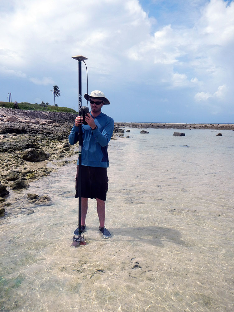
This photo shows one of the gauges that measures wave and tidal information. Eight gauges were deployed in two cross-shore transects and tied into DGPS, to get accurate tide and wave data and wave-driven water levels on across the reef.