 Many U.S. Pacific islands are atolls fringed with coral reefs and have maximum elevations of 3–5 meters, with mean elevations of 1–2 meters.
At right, aerial photograph of Kwajalein Island, southern tip of Kwajalein Atoll, part of the Republic of the Marshall Islands (RMI).
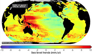
 Sea level in the western Pacific Ocean has been increasing at a rate 2–3 times the global average, resulting in almost 0.3 meters of net rise since 1990.
At right, observed trends in sea level between 1993 and 2010 (Laboratory for Satellite Altimetry, 2011). Note the high rates (5-10 millimeters/year) of sea-level rise in the western Pacific and central Indian Oceans where Department of Defense-managed atolls (Kwajalein, Wake, and Diego Garcia) are located. [Larger version]
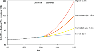
 The 2012 US National Climate Assessment provided global sea level rise scenarios that ranged from 0.2 to 2.0 meters by 2100. Regional scenarios are needed.
At right, graph depicting global sea-level rise through present, with four possible scenarios for the future. [Larger version]
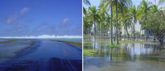
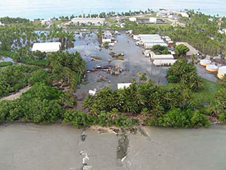
 A high surf event in December 2008 overwashed numerous atolls in Micronesia, ruining freshwater supplies and destroying agriculture on approximately 60% of the inhabited islands.
At right, overwash on Kwajalein Island, December 2008.
Photos courtesy of Department of Defense, U.S. Army Kwajalein Atoll (DoD USAKA).
 Sea-level rise will exacerbate the hazards posed by climate change (storms, waves, temperatures, precipitation, etc.) to infrastructure, freshwater supplies, agriculture, and habitats for threatened and endangered species on U.S. and U.S.-affiliated atoll islands.
At right, overwash on Roi-Namur Island, December 2008.
Photo courtesy of Department of Defense, U.S. Army Kwajalein Atoll (DoD USAKA).