|
2010 Extended Continental Shelf (ECS) Project
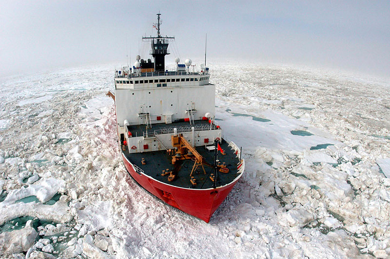
 The 2010 Extended Continental Shelf (ECS) survey was a 5-week-long expedition involving two icebreakers: U.S. Coast Guard (USCGC) Cutter Healy (at sea August 2 to September 6, 2010) and the Canadian Coast Guard Ship (CCGS) Louis S. St-Laurent (at sea August 4 to September 14, 2010). The 2010 Extended Continental Shelf (ECS) survey was a 5-week-long expedition involving two icebreakers: U.S. Coast Guard (USCGC) Cutter Healy (at sea August 2 to September 6, 2010) and the Canadian Coast Guard Ship (CCGS) Louis S. St-Laurent (at sea August 4 to September 14, 2010).
This was the sixth in a series of U.S. cruises to the Arctic Ocean, and the third in which U.S. and Canadian scientists are working together to map areas of the seafloor and to image the underlying sediment layers. The data will be used to determine the limits of the "extended continental shelf." Previous joint missions were conducted in 2008 and 2009.
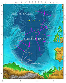
At right: planned tracklines for the 2010 U.S.-Canada Extended Continental Shelf survey. "EEZ" stands for Exclusive Economic Zone, which extends from a nation's coastline out 200 nautical miles (or to a maritime boundary with another nation). nm, nautical miles; km, kilometers. (Larger version.) Credit: USGS
Read all about the 2010 Extended Continental Shelf Project.
 |
Please read the 2010 blog by Helen Gibbons:
- August 3: “Healy on the Bering Sea”
- August 4: “Happy Birthday, Coast Guard!”
- August 6: “First Ice!”
- August 7: “Ice Gouges on the Beaufort Shelf, Plus an Alien Landing Site—The Magic of Multibeam Sonar”
- August 8: “The Mission Begins—From Wind and Waves into Tough Ice”
- August 11: “Mud, Glorious, Mud—and Gas Hydrate! A Photo Tour of Our First Day of Sampling”
- August 17-20: “Back to the Ice, Parts 1–3”:
- August 17: “We Rejoin Louis and Head into the Ice Pack”
- August 18: “Using Ice Observation and Satellite Imagery to Find a
Way Through the Floes”
- August 20: “Looking Ahead—Helicopter Reconnaissance”
- August 21: “Styrofoam Cups to 3,750 Meters—The Pressure's On!”
- August 22:
- Part 1: “Healy and Louis Exchange Visitors”
- Part 2: “Stuck in the Ice—Louis Goes with the Floe”
- August 23: “Deep CTD Cast, Part 2, Speed of Sound in Seawater”
- August 24: “On Top of the World— A Visit to the Aloft Conn ”
- August 25: “Deep CTD Cast, Part 3, What Do We Do with All This Water?
Ocean Acidification in the Arctic”
- August 28: “Scientists in the Galley—Morale Night Dinner”
- August 29: “Above the Arctic Circle—"Bluenoses, Beware!"”
- September 5: “Let Me Count the Ways”
Plus:
|
More information:
 |
According to the United Nations Convention on the Law of the Sea (UNCLOS), individual nations' sovereign rights extend to 200 nautical miles (n.mi.) (370 km) offshore in an area called the continental shelf. These rights include jurisdiction over all resources in the water column and on and beneath the seabed. Article 76 of UNCLOS also establishes the criteria to determine areas beyond the 200 n.mi. (370 km) limit that could be defined as "extended continental shelf," where a nation could extend its sovereign rights over the seafloor and sub-seafloor. This jurisdiction provided in Article 76 includes resources on and below the seafloor but not in the water column. The United States has been acquiring data to determine the outer limits of its extended continental shelf (ECS) in the Arctic and has a vested interest in declaring and receiving international recognition of the reach of its extended continental shelf.
Read more... https://pubs.usgs.gov/of/2010/1117/
|
|