Woods Hole Science Center
|
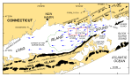
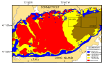
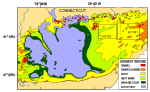
Long Island Sound, a major Atlantic Coast estuary surrounded by the most densely populated region of the United States, is 182 km long and as much as 32 km wide. It is bordered on the north by the rocky shoreline of Connecticut, on the east by The Race and Block Island Sound, and on the south by the eroding sandy bluffs of Long Island. Paleozoic bedrock and/or coastal-plain strata beneath the Sound, in southeastern Connecticut and on the north shore of Long Island are unconformably overlain by two glacial drift sheets. The older of these sheets is commonly attributed to pre-late-Wisconsinan events (Illinoian?), whereas the younger sheet is a product of the late Wisconsinan ice advance (Sirkin, 1982). Traces of two late Wisconsinan end-moraines cross Long Island (Schafer and Hartshorn, 1965; Sirkin, 1982; Stone and Borns, 1986). The Ronkonkoma moraine, which marks the maximum southern extent of the late Wisconsinan glaciation about 20 ka, lies across central and southeastern Long Island and extends eastward across the shelf in the direction of Block Island (fig. 1). To the north, a second moraine line (Harbor Hill-Fishers Island-Charlestown) caps northern Long Island and Fishers Island (fig. 1) and extends eastward across southern Rhode Island. As the ice sheet retreated from this moraine about 19 ka, meltwater was dammed behind the Harbor Hill-Fishers Island-Charlestown moraine, and a pro-glacial lake formed in the area now occupied by Long Island Sound (Lewis and Stone, 1991). During this time coastal deltas prograded into the lake, and thick deposits of fine-grained glaciolacustrine sediments accumulated on the lake bottom (Williams, 1981; Lewis and DiGiacomo-Cohen, 2000). A notch (The Race) cut in the Harbor Hill-Fishers Island-Charlestown moraine at the eastern end of the Sound is inferred to be the spillway for glacial Lake Connecticut (Stone and others, 2005). Other less prominent recessional moraines are also present between the two major moraine belts on eastern Long Island and in southeastern Connecticut, recording minor glacial readvances or stalled positions during the ice sheet's retreat (Flint and Gebert, 1976; Goldsmith, 1982; Sirkin, 1982; Stone and others, 2005). A late Wisconsinan-Holocene sequence of fluvial erosion (associated with the draining of the glacial lake that occupied Long Island Sound) was followed by a marine transgression and a subsequent transition to present conditions (Lewis and Stone, 1991). Although erosion at the spillway located in The Race lowered lake levels, and the bed of glacial Lake Connecticut was completely exposed by 15.5 ka, the rising sea started to invade the Sound by 15 ka (Stone and others, 2005). Marine conditions were well established in the Sound's basin by 13.5 ka, and glacial Lake Hitchcock in central New England was beginning to drain down the Connecticut River valley (Lewis and DiGiacomo-Cohen, 2000). The Hitchcock lake-bottom sediment, transported south by the Connecticut River between 13.5 and 9.5 ka (inferred to be about 11.5 billion m³), buried the marine unconformity and built a large marine delta (fig. 1; Stone and others, 2005). Modern circulation within Long Island Sound is tidally dominated. It is stronger in constricted areas such as the opening at its funnel-shaped eastern end, where a large volume of water must pass through a relatively narrow opening, and is weaker in the broad deeper basin of the central Sound (Signell and others, 2000). Although wind- and wave-driven currents are relatively important in shallow nearshore areas, especially during aperiodic storms when strong winds blow the length of the Sound, fresher water entering the western Sound creates a longitudinal salinity gradient that imparts a weak gravitational circulation (fig. 1; Signell and others, 2000). Modeling suggests that this combination of tidal and estuarine circulation is an effective sediment transport mechanism that is capable of eroding the marine deltaic deposits of the eastern Sound, redistributing them westward into the estuary, and building and maintaining longitudinally directed shoals such as Six Mile Reef and Long Sand Shoal (fig. 1; Knebel and Poppe, 2000; Signell and others, 2000). Scouring and redistribution of glacial and younger sediments by the strong tidal currents are common in the eastern Sound, influencing the distributions of sedimentary environments and surficial sediment (Poppe and others, 2006b). However, the westward decrease in bottom current velocities causes a progressive change from environments characterized by erosion to environments characterized by coarse bedload transport, sorting and reworking, and, finally deposition (fig. 3, Knebel and Poppe, 2000). Commensurate with this westward decrease in environmental energy is a progressive change from gravelly sediments to sand, muddy sand, and, eventually, muds (fig. 4, Poppe and others, 2000). The existence of large sand waves elsewhere in eastern Long Island Sound has long been established. Most studies have shown that these bedforms migrate westward (Bokuniewicz and others, 1977; Moore and others, 2004; Fenster and others, 2006), although other work concluded that these waves are relatively stable, migrating slowly or only in response to high-energy aperiodic storm events (Fenster and others, 1990). The data and interpretations presented herein are of a different area, greater extent, and higher resolution than these earlier studies. |
Click on figures for larger images.
|
![]() Title |
Introduction |
Setting |
Methods |
Results |
Discussion |
Data Catalog |
Acknowledgments |
References |
Figures |
Contacts |
Disclaimers
Title |
Introduction |
Setting |
Methods |
Results |
Discussion |
Data Catalog |
Acknowledgments |
References |
Figures |
Contacts |
Disclaimers