|
|
The multibeam bathymetric data presented herein were acquired for hydrographic charting applications during 2004 aboard the NOAA Ship Thomas Jefferson (fig. 5). Surveys H11252 and H11361, which cover approximately 64 km² and 92 km² of the sea floor respectively, were primarily conducted using the ship's hull-mounted, 95-kHz Simrad EM1002 multibeam echo-sounder. Shallower areas (<20 m) within these surveys were surveyed by launches equipped with hull-mounted 455-kHz Reson Seabat 8125 and 240-kHz Reson 8101 multibeam echo-sounder systems (figs. 6, 7, 8, 9).
The survey lines were generally run parallel to the bathymetry contours at a line spacing three to five times the water depth. Navigation was by differential GPS-assisted inertial navigation systems; Hypack MAX was used for acquisition line navigation. Sound velocity corrections were derived using frequent SEACAT CTD (conductivity-temperature-depth) profiles (fig. 10). Typically, a CTD cast was conducted every four to six hours of multibeam acquisition. Vertical datum is mean lower low water; vertical accuracy is approximately 0.5% of the water depth.
Most processing of the bathymetric data was performed at sea. Artifacts and false soundings were removed, data were adjusted for tidal variations to mean lower low water, and the bathymetric data were gridded to a continuous surface. Detailed descriptions of the processing performed to create the datasets presented in this report are included in the metadata files. These file can be accessed through the Data Catalog section of this report. Imagery derived from the multibeam observations shows sea floor topography in shaded relief at a spatial resolution of 2 m/pixel. Although continuous coverage was typically achieved, small patches of no data in the datasets (notably the northwestern part of survey H11252) resulted from onboard equipment problems. All navigation was by differential GPS.
A dual frequency Knudsen 320BR 2-7 kHz CHIRP and 200 kHz echo-sounder system collected high-resolution seismic-reflection subbottom profile data concurrently with the ship's multibeam bathymetry. This system used hull-mounted transducers and recorded the data in SEG-Y digital format. Boomer data from an earlier cruise aided in the geologic interpretation of the multibeam data (Lewis and Needell, 1987; Poppe and others, 2002a).
Interpretations of sea-floor features and sedimentary environments are based on existing surficial sediment data and bottom photography (Poppe and others, 2000), seismic profiles, and bathymetry. Sediment descriptions are based on the nomenclature proposed by Wentworth (1922; fig. 11), the inclusive graphics statistical method of Folk (1974) and the size classifications proposed by Shepard (1954; fig. 12). A detailed discussion of the laboratory methods employed is given in Poppe and others (2005). For the purposes of this paper, bedforms are defined by morphology and amplitude. Giant barchanoid and transverse sand waves are >17 m high; sand waves are >1 m high; megaripples are 0.2-1 m high; ripples are < 0.2 m.
|
Click on figures for larger images.
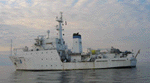 |
Figure 5. Port-side view of the NOAA Ship Thomas Jefferson at sea. Note that the 30-foot survey launch normally stowed on this side of the ship has been deployed.
|
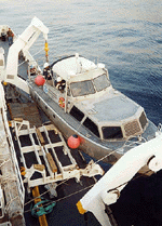 |
Figure 6. Image showing NOAA Launch 1014 being deployed from the NOAA Ship Thomas Jefferson.
|
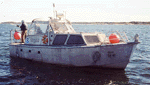 |
Figure 7. Image showing a starboard-side view of NOAA Launch 1014 afloat.
|
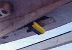 |
Figure 8. Image showing the Reason 8125 multibeam transducer mounted to the hull of the NOAA Launch 1014.
|
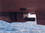 |
Figure 9. Image showing the Reason Seabat 8101 hull mounted in the keel cut out of NOAA Launch 1005.
|
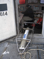 |
Figure 10. CTD (conductivity-temperature-depth) profiler shown on the deck of the NOAA Ship Thomas Jefferson. Data derived from frequent deployments of this device were used to perform sound velocity corrections on the multibeam data.
|
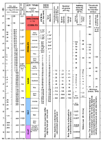 |
Figure 11. Correlation chart showing the relationships between phi sizes, millimeter diameters, size classifications (Wentworth, 1922), and ASTM and Tyler sieve sizes. Chart also shows the corresponding intermediate diameters, grains per milligram, settling velocities, and threshold velocities for traction.
|
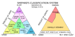 |
Figure 12. Sediment classification scheme from Shepard (1954), as modified by Schlee (1973).
|
|


