USGS Coastal and Marine Hazards and Resources Program
Geophysical Mapping of Oyster Habitats in a Shallow Estuary; Apalachicola Bay, Florida
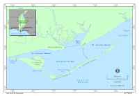
This report presents high-resolution geophysical data, interpretive maps, and a preliminary discussion about the oyster habitat and estuary-floor geology within Apalachicola Bay, Florida (fig. 1). During two research cruises, conducted in 2005 and 2006, approximately 230 km² of the bay floor were surveyed using interferometric-bathymetry, sidescan-sonar, and chirp seismic-reflection techniques. The research was conducted as part of a cooperative program between the U.S. Geological Survey (USGS), the National Oceanic and Atmospheric Administration Coastal Services Center (CSC), and the Apalachicola Bay National Estuarine Research Reserve. The Apalachicola Bay National Estuarine Research Reserve was established in 1979 to provide opportunities for long-term monitoring and research to provide a basis for more informed coastal management decisions for this estuary. Apalachicola Bay is the largest oyster fishery in Florida (Whitfield and Beaumariage, 1977), and the primary objective of this program is to develop a suite of maps that define oyster habitat distribution and estuary-floor geology within the bay. The resulting maps will assist in effective management of oyster resources and provide a reference geologic framework for future scientific and applied research. |
Click on figure for larger image.
|
![]() Title |
Figures |
1-Introduction |
2-Data Collection and Processing |
3- Geologic Interpretation |
4-References |
5-Maps |
Spatial Data |
Acknowledgments
Title |
Figures |
1-Introduction |
2-Data Collection and Processing |
3- Geologic Interpretation |
4-References |
5-Maps |
Spatial Data |
Acknowledgments