USGS Coastal and Marine Hazards and Resources Program
Geophysical Mapping of Oyster Habitats in a Shallow Estuary; Apalachicola Bay, Florida
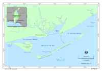
SettingApalachicola Bay is a large estuary located along the coast of the Florida panhandle between Tallahassee and Pensacola (fig. 1). It is approximately 65 km long and 5.5 to 12 km wide, except at its western end, where it narrows to less than 2 km. The estuary is shallow, having a mean depth of 2 to 2.4 m. It is divided into four provinces: St. George Sound, Apalachicola Bay, East Bay, and St. Vincent Sound (fig. 1). The western end and southern side of the estuary are shielded from the open Gulf of Mexico by a string of barrier islands: Dog Island, St. George Island, Little St. George Island, and St. Vincent Island. The eastern end of the estuary is open to the Gulf of Mexico. Salt water exchange occurs at its eastern end and through four inlets: East Pass, between Dog and St. George Islands, Government Cut, between St. George and Little St. George Islands, West Pass, between Little St. George and St. Vincent Islands, and Indian Pass, at the western end of St. Vincent Island. The Apalachicola River delivers freshwater to this estuary where it enters through East Bay. It is the largest river in the state of Florida (Leitman and others, 1983), and its drainage basin includes large parts of eastern Alabama and western Georgia. Its headwaters are in northern Georgia (fig. 1). The Quaternary geology of the Apalachicola Bay region records several dramatic changes in sea level that were caused by periodic glacial retreat and advance (Riggs, 1980). During glacial periods, when sea level was low, the Apalachicola River incised channels across the present coastal and inner-shelf region (Donoghue, 1993), building deltas on the middle and outer shelf (McKeown and others, 2004; Gardner and others, 2005). During interglacial periods, sea level rose and the paleo-river channels were filled with deltaic and estuarine deposits (Schnable and Goodell, 1968). The present Apalachicola Bay estuary appears to have formed starting 3,000 to 4,000 years ago with the formation of the barrier islands that rim the bay (Stapor, 1975; Donoghue and White, 1995). After the initial formation of the barrier islands, sea level continued to rise, and the delta continued to retreat (Donoghue and White, 1995). Fine-grained prodelta sediment accumulated beyond the delta front, but largely within the bay, with little escaping to offshore regions (Bedosky, 1987). It is in this estuarine setting that oysters thrive. |
Click on figure for larger image.
|
![]() Title |
Figures |
1-Introduction |
2-Data Collection and Processing |
3- Geologic Interpretation |
4-References |
5-Maps |
Spatial Data |
Acknowledgments
Title |
Figures |
1-Introduction |
2-Data Collection and Processing |
3- Geologic Interpretation |
4-References |
5-Maps |
Spatial Data |
Acknowledgments