USGS - science for a changing world

USGS Coastal and Marine Geology Program

U.S. Geological Survey Open-File Report 2006-1381

Geophysical Mapping of Oyster Habitats in a Shallow Estuary; Apalachicola Bay, Florida


Maps

Skip past contents information

Section 5-
Maps

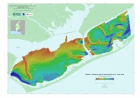
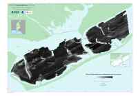
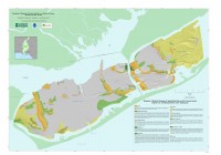
Three large-format mapsheets (1:30,000) illustrate the bathymetry, sidescan-sonar backscatter data, and surficial geology of the Apalachicola Bay and St. George Sound survey areas. These mapsheets are distributed as Adobe portable document format (PDF) files that can be printed on a large format plotter at 45 x 32 inches.

Mapsheet 1. Bathymetry, presents a regional bathymetric model for the area using a 25-m grid cell resolution. Mapsheet 1. Bathymetry, presents a regional bathymetric model for the area using a 25-m grid cell resolution. (PDF format)

Mapsheet 2. Sidescan-sonar backscatter, shows distribution of backscatter values over the survey area. Mapsheet 2. Sidescan-sonar backscatter, shows distribution of backscatter values over the survey area. (PDF format)

Mapsheet 3. Surficial geology, shows the interpreted surficial geology with the locations of oyster bars superimposed on the sun-illuminated bathymetry. Mapsheet 3. Surficial geology, shows the interpreted surficial geology with the locations of oyster bars superimposed on the sun-illuminated bathymetry. (PDF format)


Adobe Reader To view files in PDF format, download free copy of Adobe Reader.

Skip past footer information

Skip past bottom index informationTitle | Figures | 1-Introduction | 2-Data Collection and Processing | 3- Geologic Interpretation | 4-References | 5-Maps | Spatial Data | Acknowledgments

Skip Navigation

Accessibility FOIA Privacy Policies and Notices

U.S. Department of the Interior | U.S. Geological Survey | Coastal and Marine Geology

URL: cmgds.marine.usgs.gov/publications/of2006-1381/html/maps.htm
Page Contact Information: CMGDS Team
Page Last Modified: Wednesday, 06-Dec-2017 13:08:15 EST