|
This data report presents oceanographic observations made at eight locations in Long Bay, South Carolina, from October 2003 through April 2004 (fig. 1.) These locations were offshore of Myrtle Beach, South Carolina, and centered on a shore-oblique sand deposit that is approximately 10 kilometers long, 2 kilometers wide, and in excess of 3 meters thick. The observations were collected through a collaborative effort with the U.S. Geological Survey (USGS), the University of South Carolina (USC), and Georgia Institute of Technology (GT) as part of a larger study to understand the physical processes that control the transport of sediments in Long Bay (See http://woodshole.er.usgs.gov/project-pages/scarolina/html/po.htm). Funding for this work was provided by the South Carolina Coastal Erosion Project (http://pubs.usgs.gov/fs/2005/3041/), a cooperative study supported by the USGS and the South Carolina Sea Grant Consortium (Sea Grant Project No: R/CP-11).
|
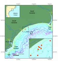
Figure 1. Location Map for Long Bay, South Carolina. Click on figure for larger image in PDF format. |
|
|
A large suite of instruments was deployed to measure waves, currents, and sediment transport near the region of the offshore sand feature in Long Bay. The measurements provided information on water flow, sea level, conductivity, temperature, wave characteristics, near-bottom turbulence, suspended sediment concentrations, and sea floor bedforms (ripples). This information is important to the understanding of water circulation and sediment fluxes in Long Bay.
This data report presents a description of the study background, a description of the field program, instrumentation, and data processing and archival techniques, and all observational data. The objective of this report is to make the data available in digital form and to provide information to facilitate further analysis of the data. The edited data are presented in time series plots for rapid visualization of the data set, and in data files which are in the NetCDF format. Harmonic analysis of the observations is also included to describe the tidal characteristics of Long Bay. Standard meteorological data and river discharge data, obtained from other sources in the area, are also provided to describe the climatologic and hydrologic characteristics of the region.
|