Meteorological Observations
Wind speed and direction, wave height and period, air temperature, sea surface temperature, and barometric pressure are recorded by instruments maintained in Long Bay by the National Oceanic and Atmospheric Administration (NOAA) National Data Buoy Center (NDBC) (http://www.ndbc.noaa.gov/Maps/Southeast.shtml), and by NOAA National Ocean Service (NOS) (http://www.nos.noaa.gov/). Hourly data from October 1, 2003 to May 1, 2004, obtained from NDBC stations 41013 and FPSN7, and NOS stations 8661070 and 8659897 (fig. 49), are included in this data report. Also included are wind speed and direction data at three-hour intervals from the Coupled Ocean/Atmosphere Mesoscale Prediction System (COAMPS®) (http://www.nrlmry.navy.mil/coamps-web/web/home).
| Station |
Location |
Latitude |
Longitude |
|---|
| 41013 |
Frying Pan Shoals, SC |
33° 28' 43" N |
77° 35' 00" W |
| FPSN7 |
Frying Pan Shoals, SC |
33° 29' 06" N |
77° 35' 24" W |
| 8661070 |
Springmaid Pier, SC |
33° 39' 18" N |
78° 55' 06" W |
| 8659897 |
Sunset Beach, NC |
33° 51' 54" N |
78° 30' 24" W |
|
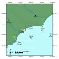
Figure 49. Location Map for supporting observation stations in Long Bay, South Carolina (SC). Click on figure for larger image (PDF format). |