Home - Images - Products - Data - Publications - Contact
Return to Los Angeles Home Page
Click on the arrows within the index map below or go to the thumbnail images to choose a perspective view.
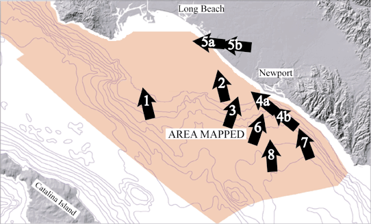
Fig. 1 Larger View (172 kb) |
Figure 1. Perspective view of continental shelf south of San Pedro Bay looking north. Seafloor image is backscatter draped over bathymetry; reds and oranges are high backscatter, blues and greens are low backscatter. Gray area is land, black area is unmapped. Areas of high backscatter are rock outcrops that rise less than 5 m above the surrounding seafloor. The distance across the bottom of image is 4 km; water depths range from 19 m to 50 m. Vertical exaggeration 10x. |
Fig. 2 Larger View (134 kb) |
Figure 2. Perspective view of continental shelf adjacent to Huntington Beach, CA looking north. Seafloor image is backscatter draped over bathymetry; reds and oranges are high backscatter, blues and greens are low backscatter. Gray area is land, black area is unmapped. Linear high-backscatter seafloor features perpendicular to coastline are depressions ~20-m wide,and ~0.5-m deep. Distance across bottom of image is 2.7 km, water depth range from 25 m to 70 m deep. Vertical exaggeration 10x. |
Fig. 3 Larger View (157 kb) |
Figure 3. Perspective view of continental shelf adjacent to area between Huntington Beach and Newport Beach, CA looking north. Seafloor image is backscatter draped over bathymetry; reds and oranges are high backscatter, blues and greens are low backscatter. Gray area is land, black area is unmapped. The two linear features are Orange County Sanitation District ocean outfall pipes. Notice zone of high backscatter (green) around an south of outfall pipe. High-backscatter linear features perpendicular to coast are depressions ~20-m wide,and ~0.5-m deep. (similar to those shown in Fig. 2). Distance across bottom of image 2.4 km, portion of long pipe shown is 5.1 km long. Vertical exaggeration 10x. |
Fig. 4a Larger View (145 kb) |
Figure 4a. Perspective view of color-coded bathymetry of the continental shelf adjacent to area between Huntington Beach and Newport Beach, CA looking northwest. Water depths vary from 10 m (red) to 60 m (light orange). Gray area is land, black area is unmapped. The two linear features are Orange County Sanitation District ocean outfall pipes. |
Fig. 4b Larger View (144 kb) |
Figure 4b. Same perspective view of continental shelf as in Figure 4a but in this view the seafloor image is backscatter draped over bathymetry; reds and oranges are high backscatter, blues and greens are low backscatter. Notice zone of high backscatter (green) around an south of outfall pipe. Distance across bottom of image 2.3 km. Vertical exaggeration 5x. |
Fig. 5a Larger View (135 kb) |
Figure 5a. Perspective view of color-coded bathymetry of the continental shelf south of San Pedro Bay and Long Beach, CA, looking west. Water depths vary from 10 m (red) to 80 m (yellow). Gray area is land, black area is unmapped. Linear feature is cable and pipeline leading from Huntington Harbor to Edith platform (off image at left). |
Fig. 5b Larger View (150 kb) |
Figure 5b. Same perspective view of continental shelf as in Figure 5a but in this view the seafloor image is backscatter draped over bathymetry; reds and oranges are high backscatter, blues and greens are low backscatter. High-backscatter outcrops occur on the seafloor southeast of Palos Verdes Peninsula; linear depressions (see Figure 3) occur on the lower right of image. |
Fig. 6 Larger View (131 kb) |
Figure 6. Perspective view of the seafloor off Newport Bay, CA, looking north. Vertical exaggeration is 5x. Red colors show depth ranges from 5m to approximately 120m on the continental shelf. Yellows and light greens show depth ranges from approximately 120m to 370m on the continental slope. Black areas are too shallow to map with the multibeam system. Grey shades show land elevations ranging from 0m to 300m. The distance across the bottom of the image is 6.3km. The image shows that the narrow continental shelf immediately south of the Newport Bay broadens to the northwest. Only one deep channel of the several major canyons of the Newport Canyon system incises the shelf, and extends almost to the beach. This incised canyon is 150m wide and 8m deep directly offshore Newport Bay. |
Fig. 7 Larger View (114 kb) |
Figure 7. Perspective view of colored bathymetry off Newport, CA looking north. Vertical exaggeration 5x. Grayscale is land, black area are not mapped. Distance across bottom of image 1.85 km. Depth range from dark blue 153 m to dark pink 7 m. |
Fig. 8 Larger View (111 kb) |
Figure 8. Perspective view of colored bathymetry at the head of Newport Canyon system on the upper slope off Newport Beach, CA, looking north. Illumination elevation 45°, azimuth 315°. Distance across bottom of image 4.2 km, vertical exaggeration 5x. Gray land surface is USGS 30-m DEM, black area is unmapped continental shelf. |
