
The December 26, 2004 Indian Ocean Tsunami: Initial Findings on Tsunami Sand Deposits, Damage, and Inundation in Sri Lanka
Tsunami Heights
The change in tsunami height with distance from the shoreline is important information for determining how the tsunami lost energy as it moved inland. Casualties and damage to structures are strongly related to the height of a tsunami not only at the shoreline, but to how it decreases inland.
Because there were structures and trees remaining in many locations in Sri Lanka where the tsunami was large, tsunami height information collected by the ITST is one of the best data set ever collected on how a tsunami looses energy moving inland. Water levels are usually greatest near the shoreline and decrease to zero at the limit of tsunami penetration where all the energy of the tsunami is expended. Water levels near the shoreline measured by the Sri Lanka ITST varied from less than 3 meters to more than 10 meters. In general, water levels, and by inference tsunami height, near the shoreline increased on the East Coast of Sri Lanka towards the South, and on the South coast toward the East.
There was, however, considerable variability caused by a number of factors including underwater topography (focusing or defocusing of tsunami energy, removal of energy by drag on the bottom and breaking) and orientation of the coastline. In areas where the there were no structures or trees left standing after the tsunami, tsunami height will be modeled using inundation distance, run-up elevation, and topographic data.
 Sand and bricks on top of the Post Office at Kalmunai were left by the tsunami. The height of the tsunami here was more than 4.75 m. Photograph courtesy of Phillip Liu, Cornell University. (larger image, 199 kb) |
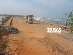 The tsunami overtopped the bridge, which is 3.7 m above sea level, at Kuchchaveli. (larger image, 136 kb) |
 Gouge marks in tree formed by debris carried by the tsunami indicate tsunami height of greater than 2 m at about 150 m inland from the shoreline at Mankerni. (larger image, 217 kb) |
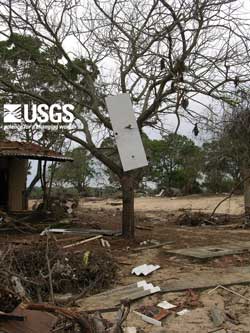 Flow depths were about 4.5 m at Yala Safari Resort where water level were determined by debris in the trees, including a door impaled on a branch. (larger image, 221 kb) |
 Damage to Structures
 |
 |
 |
 |