
The December 26, 2004 Indian Ocean Tsunami: Initial Findings on Tsunami Sand Deposits, Damage, and Inundation in Sri Lanka
Damage to Structures
Damage to structures in Sri Lanka was most apparent in areas where part of the structure was left standing. Often though, the only indication of a pre-existing structure was a remnant of a foundation. Damage to structures from the tsunami in Sri Lanka was greatest where the tsunami height was greatest. In some places there was a zone near the coast where all structures were completely destroyed. For example, in one part of Kalmunai, the zone of destruction extended about one-half a kilometer inland. However, the damage to structures was variable over short stretches of coast. Less than 2 km from this location, most of the structures were standing and relatively undamaged at distances greater than 100 meters from the shoreline. This variability could be the result of both variability in the tsunami and in the quality of construction.
|
|
||||
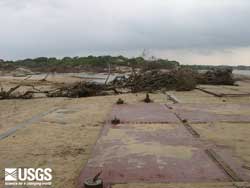
 Rooms at the Yala Safari Resort before the tsunami. (larger image, 156 kb) |
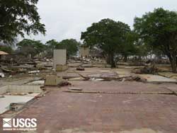
 Rooms at the Yala Safari Resort after the tsunami. (larger image, 126 kb) |
||||
 Another photo of the Yala Safari Resort after the tsunami. (larger image, 175 kb) |
 Nearly all the buildings within 500 m of the coast were destroyed at Kalmunai. Photograph courtesy of Phillip Liu, Cornell University. (larger image, 138 kb) |
||||
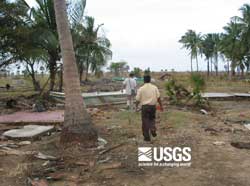 The tsunami removed houses about 75 m inland at Mankerni—all that is left is their foundations. Note the boats transported inland by the tsunami. The hole in the lower right portion of the photograph was made by the ITST when it examined tsunami sand deposits. (larger image, 143 kb) |
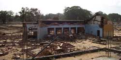
 A TV set and toilet are among the rubble at Perelyga where a train was hit broadside by the tsunami killing all aboard. (larger image, 155 kb) |

 Tsunami Sand Deposits
 |
 |
 |
 |