
The December 26, 2004 Indian Ocean Tsunami: Initial Findings on Tsunami Sand Deposits, Damage, and Inundation in Sri Lanka
Inundation Distances and Run-up Elevations
The power of the tsunami in Sri Lanka was documented by measuring inundation distances and run-up elevations.
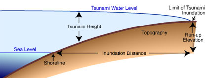
Inundation distance—the distance from the shoreline to the limit of tsunami penetration
Inundation distance measured by the Sri Lanka ITST varied from less than 50 meters to more than 1 kilometer. In general, inundation distance increased on the East Coast of Sri Lanka towards the South. There was, however, considerable variability caused by a number of factors, including slope of the land (greater inundation distances in flatter areas), underwater topography, and orientation of the coastline. The South and West coasts of Sri Lanka are characterized by rocky headlands and intervening embayments with narrow beaches and low, coastal plain topography. Tsunami inundation was greatest in the embayments. Measured inundation distances will be compared to predictions to improve the ability to model future tsunamis in Sri Lanka and elsewhere.
Run-up elevation—the elevation above sea level of a tsunami at the limit of penetration
Run-up elevation measured by the Sri Lanka ITST varied from less than 3 meters to more than 12 meters. In general, run-up elevation increased on the East Coast of Sri Lanka towards the South. On the South and West coasts runup elevation typically was greatest at the headlands. There was, however, considerable variability caused by a number of factors, including slope of the land (lower run-up elevations in flatter areas), underwater topography, and orientation of the coastline. Measured run-up elevations will be compared to predictions to improve the ability to model future tsunamis in Sri Lanka and elsewhere.
 Tsunami Heights
 |
 |
 |
 |