
The December 26, 2004 Indian Ocean Tsunami: Initial Findings on Tsunami Sand Deposits, Damage, and Inundation in Sri Lanka
Importance of Survey
Importance of Collecting Data Soon after the Tsunami
Evidence of tsunami flow depth, flow direction, run-up elevation, and maximum inundation is easily destroyed or altered by weather and clean-up efforts. Because data for these parameters is invaluable for determining what areas are most at risk from tsunamis, it is important to collect data as soon as possible after the tsunami. The Sri Lanka ITST monitored humanitarian relief efforts and mobilized as soon as it was determined that collection of scientific data would not hinder relief efforts. Sri Lanka will use data collected by the ITST to plan where and how to rebuild in the aftermath of the tsunami. The data collected by the Sri Lanka ITST will also be used to improve our understanding and predictive capability for tsunami hazards worldwide.
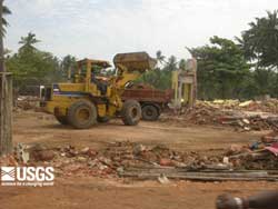 Bulldozers and front-end loaders had already redistributed the rubble and cleaned up much of the debris in some of the areas of Sri Lanka visited by the survey teams. It is necessary to document sedimentary deposits as soon after the tsunami as possible, for the need to rebuild communities will often destroy valuable data. (larger image, 178 kb) |
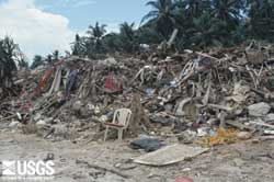 Tsunami debris in Matara was cleared and collected in piles on the beach by the time the Sri Lanka ITST visited the site. (larger image, 180 kb) |
Importance of Tsunami Sand Deposits in Tsunami Risk Assessment
Once the water from a tsunami is gone, we can still learn about the tsunami from the sand it left behind. Tsunamis often leave a deposit of sand—a calling card—to mark that a tsunami has been there. These tsunami sand deposits, if preserved in the geologic record, can be used to help assess the tsunami hazard. See also:
- "Using tsunami deposits to improve assessment of tsunami risk" CD02_TsuDepRisk.pdf (956 kb); and
- USGS Open-File Report OF03-13 "Cascadia Tsunami Deposit Database").
In some cases, this record may be the only evidence that a location may be at risk from a tsunami. Where more than one tsunami deposit is preserved in a stratigraphic sequence, the sedimentary record may help determine how often a tsunami is likely to occur. Tsunami sediments also record important information about the wave that deposited them. By examining the thickness and grain size distribution of tsunami deposits, scientists are able to deduce the wave height and flow velocity of the wave. Wave height and flow velocity are among the most important properties of a tsunami that determine how destructive the wave is. By studying sediments from the tsunami in Sri Lanka, we can learn more about the tsunamis, as well as improve the ability to identify and interpret tsunami sediments in the geologic record of Sri Lanka and elsewhere.
USGS scientists have participated in prior tsunami sediment surveys in Papua New Guinea and Peru:
- sediments deposited by the 1998 Papua New Guinea tsunami;
- "Erosion and sedimentation from the 17 July 1998 Papua New Guinea tsunami" pageoph2003PNGtsudep.pdf (1.4 MB);
- "Preliminary Analysis of Sedimentary Deposits from the June 23, 2001 Peru Tsunami"; and
- "Identification and Interpretation of Tsunami Deposits from the June 23, 2001 Peru Tsunami" CS03_PeruTsuDep.pdf (2.2 MB).
 Survey and Methods
 |
 |
 |
 |